
Reducing the risk of bird strikes using satellite images and Ascend’s Normalised Difference Water index software (NDWI)


BROWSE PROJECTS
Based on user needs and industry skills, the evolution of customized solutions and the establishment of innovative services is accomplished through project activities. Focusing on various thematic areas, relevant information on the project activities is provided below.
Orbio Earth Platform
Status date: 25 March 2024
The OE Platform uses satellites to track methane emissions from the oil & gas industry. This enables management of methane and associated energy transition risks using global, asset-level, highly frequent emissions data embedded into a deep regulatory, supply chain, portfolio exposure and operations analytics.
Remote Ecological Surveys
Status date: 02 April 2024
To restore and protect biodiversity, we need detailed data. A breakthrough is needed in the current labour intensive methods to carry an ecological survey to provide data for biodiversity monitoring and reporting. Gentian provides a solution which harnesses innovative AI technology and highest resolution Remote Sensing imagery to provide a fully remote, cost efficient ecological survey without compromising on accuracy.
Project Eclipse
Status date: 02 April 2024
Following a successful feasibility study for a multipurpose shared electric fleet solution for NHS Hospitals, Project Eclipse covers the development and pilot of a new and highly innovative transport technology for Newcastle Hospitals NHS Foundation Trust. The project sets out to reduce transport related challenges for employees and patients by providing a sustainable, optimised, fully electric fleet solution that improves access, reduces cost and helps the NHS meet ambitious Net Zero targets.

Methane Watch
Status date: 02 April 2024
Methane Watch is the world’s first monitoring system to measure the methane footprint of the energy sector. It combines Earth Observation data from the Copernicus constellation, NASA, NOAA and commercial satellites with advanced analytics to monitor emissions from oil, gas and coal with unprecedented accuracy, and provides unique insights to decarbonise the energy industry on a global scale.
GIP 4 Smart Airports
Status date: 05 December 2022
The GIP 4 Smart Airports solution provides all actors of airport ground operations (e.g. airlines, airport, handlers) with better, accurate, real-time information about ongoing turnaround operations. GIP 4 Smart Airports offers a non-intrusive, bird-eye view of airport activities, without intruding and disrupting current working practices of airport teams, while making real-time information available to everyone.
DINAMO
Status date: 26 March 2024
DINAMO is a multi-sensor multi-temporal platform representing an operational tool designed for the early-warning and detection of possible structural failures designed with the purpose to provide a solution to the growing need of reliable and durable operational tools for bridges and viaducts continuous
VunaNexus
Status date: 27 November 2023
VunaNexus uses a patented technology to transform human and livestock urine into two valuable products: a fertiliser free of all dangerous pollutants and water that can be reused, this while drastically reducing ammonia emissions and water pollution.
DECISIONX:NETZERO
Status date: 13 March 2024
SATAVIA is reducing the climate impact of flying by mitigating the warming effect from the clouds aircraft make and enabling airlines to claim carbon credits as an incentive. Globally, aircraft contrails trap heat in the atmosphere and increase aviation’s climate impact by over 30%, contributing to global warming. From 2025 the European Union Emission Trading Scheme (EU ETS) will require airlines to report this impact.
SATAVIA’s technology provides atmospheric intelligence to change flight plans to avoid contrail-forming conditions. The mitigated climate impact is verified by SATAVIA and converted into tradable units by a patented method with the backing of Gold Standard, a major carbon accreditation platform.
Urban Green Quality Tracker
Status date: 25 January 2023
Enabling the Smart Green Cities of the future by providing a dashboard of the health, extent and impact of the cities urban green.
EO4CSR
Status date: 12 March 2024
The EO4CSR project aimed to assess the potential of Earth observation (EO) derived information to enable companies and financial institutions to facilitate due diligence and reporting requirements deriving from the European CSR Directive (Corporate Social Responsibility - CSRD) and European Deforestation Regulation (EUDR).
DECOM
Status date: 07 March 2024
THERMALEEGO
Status date: 07 March 2024
Revolutionize energy asset inspection with ThermAleego: AI-powered software using thermal imaging and space assets for precise anomaly detection, optimal maintenance, and cost savings.
HIRES-CURRENT-PERF
Status date: 06 March 2024
This feasibility study quantifies the performance of short-term optimal routing mode using a new generation of surface currents data obtained by AI fusion of high-resolution satellite observations.
RT5.0
Status date: 27 November 2023
Rural Tourism 5.0 (RT5.0) is a next generation travel planning ‘eco-algorithm’, designed to improve the visitor experience, impact on the environment, and the economic output of rural tourist destinations.
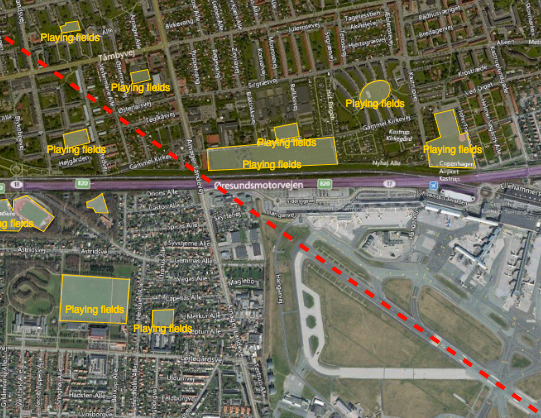
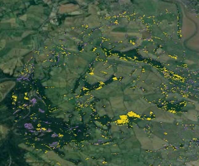
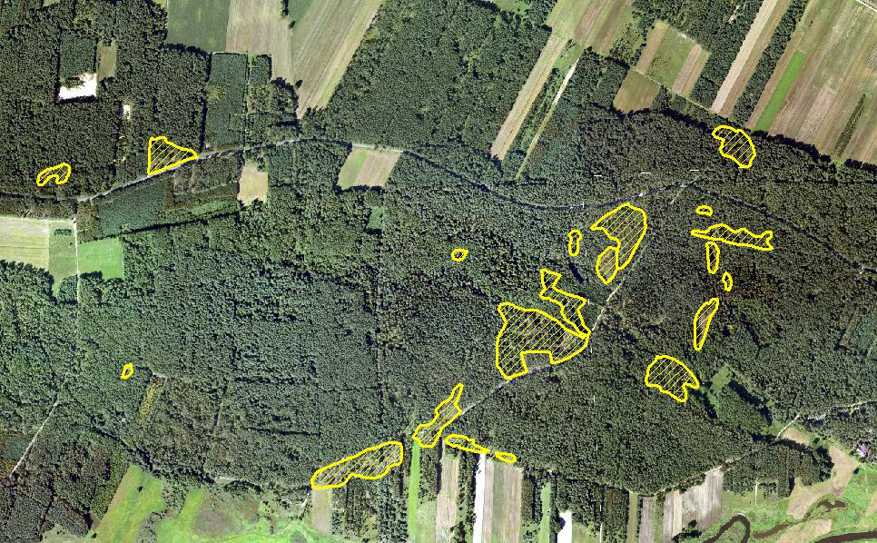
LUCI
Status date: 22 September 2022
Project LUCI aims to assess land use around railway infrastructure and detect changes that could be hazardous to the safe running of the railway. The project aims to give trackside managers crucial information to enhance the decision making process and ultimately make the railways a safer place to work and travel.
SNA
Status date: 04 August 2023
The Smart Nurse Assistant project introduces an innovative solution to automate repetitive tasks in
healthcare. It will provide an unmanned medical equipment delivery robot service to effectively lower the
pressure on the nurses and other healthcare personnel by taking over some of the time-consuming tasks of
delivering items and equipment between hospital departments, nursing homes and similar healthcare
institutions.
EO Diagnostics
Status date: 04 March 2024
In this transformative project AI-driven diagnostics, and Earth Observation (EO) data are bridged to
revolutionize patient care and early disease prediction. AI, fueled by satellite data, enables early disease
prediction by analyzing environmental factors such as UV exposure and dust concentrations. This approach
extends beyond traditional healthcare, addressing global health and environmental challenges.
AROBS AlertBox
Status date: 04 March 2024
AROBS AlertBox aims to offer access to E-alert messages and 112 emergency service, in environments that lack reliable GSM (Global System for Mobile Communication). This product is an emergency alert box that connects, via the Iridium global satellite constellation system, , to the national emergency response systems in critical situations when communication channels are compromised.
ORCAS
Status date: 01 March 2024
Trade in Space creates NFTs on a blockchain, using SatEO analysis. But these aren’t works of art – they're tied to physical commodity crops still growing in the field and this new approach enables us to move into a new age of transactional insight®. In this project Trade in Space will show the value this new approach has in streamlining global coffee and cacao supply-chains.