
Objectives of the service
There is a growing awareness across all industries of the biodiversity crisis. Urgent action is needed to protect and improve biodiversity and halt its rapid decline. In order to bring about a positive change, we need up-to-date, reliable nature data.
The implementation of the Global Biodiversity Framework has led to national and regional regulations being introduced requiring organisations from both the public and private sector to comply with targets for biodiversity improvements.
To fulfil the demand for data, the current process of manual ecological surveying is too slow, subject to logistical limitations, of varying quality and can be expensive. Collecting data in this way presents problems with lack of data consistency for baselines and subsequent monitoring, and will not produce enough data with the time-sensitivity needed for biodiversity monitoring, reporting and verification. Whilst some data exists in local and global data banks, there is limited coverage and the data that is available is often out-dated.
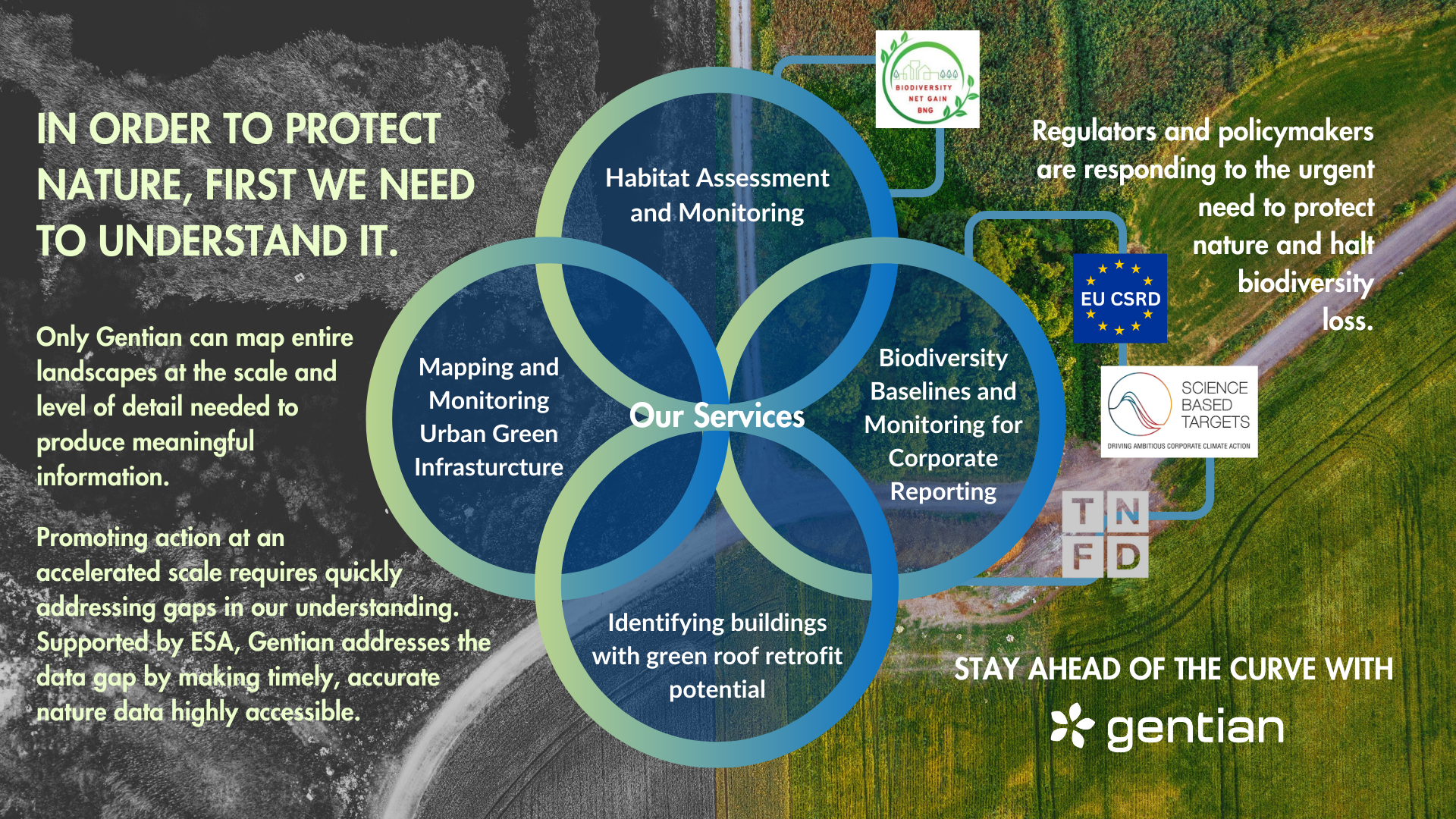
Gentian provides access to up-to-date data that is suitable for biodiversity reporting. Our AI identifies and classifies habitat types using satellite imagery and the very latest deep learning technology. Our remote assessments provide data in familiar formats, such as a preliminary ecological assessment, compatible with national and international habitat classification systems and framework reporting methodologies, such as UK Biodiversity Net Gain (BNG) or the international Taskforce on Nature-related Financial Disclosures(TNFD).
Gentian’s innovative assessment technology is able to assess vegetation in both the urban and rural landscape, on a global scale. Our unique Green Roof Identification Assessments locate and classify green roofs by category, and identify opportunities for implementing green roofs via building retrofit, giving a better understanding of opportunities to improve urban climate resilience and foster greater biodiversity.
Users and their needs
Key users of our service can be categories in three broad categories:
-
Municipalities/Local Authorities
UK and EU municipal and local authorities have expressed interest in Gentian’s service, which provides data that is not available to them elsewhere for urban planning (natural ecosystems for climate resilience and biodiversity restoration and preservation).
Our urban assessments provide access to data that is not readily available in existing data platforms and which requires resources (time and budget) that are not readily available.
-
Real Estate Owners and Developers: Regulations at national and international level, are targeting any new sites that are to be developed and mandating that organisations, at a site level must demonstrate no net loss and, depending on the location, positive net gain in the natural capital that is found there (vegetation). Gentian’s data service provides relevant data to land owners and developers to enable risks and opportunities associated with their assets and activities to be identified at different stages of the site development lifecycle and subsequent monitoring of the site.
-
Large corporations: Large corporations around the world are facing greater public and regulatory pressure to report on their nature-related impacts and dependencies. The scalability and remote delivery of Gentian’s nature data solves the problem of lack of right time, right format data for companies around the world, to be able to get a handle on biodiversity baseline values and to create plans to protect and improve natural habitat, and then to report on strategic goals routinely.
Service/ system concept
Precision data for biodiversity monitoring.
Gentian’s service provides easy access to data for reporting on impact to natural capital, in line with national and international reporting frameworks, in a fraction of the time and at a fraction of the cost of manual on-site surveys.
Our algorithms produce highly accurate output that has been independently validated in earlier feasibility and pilot studies.
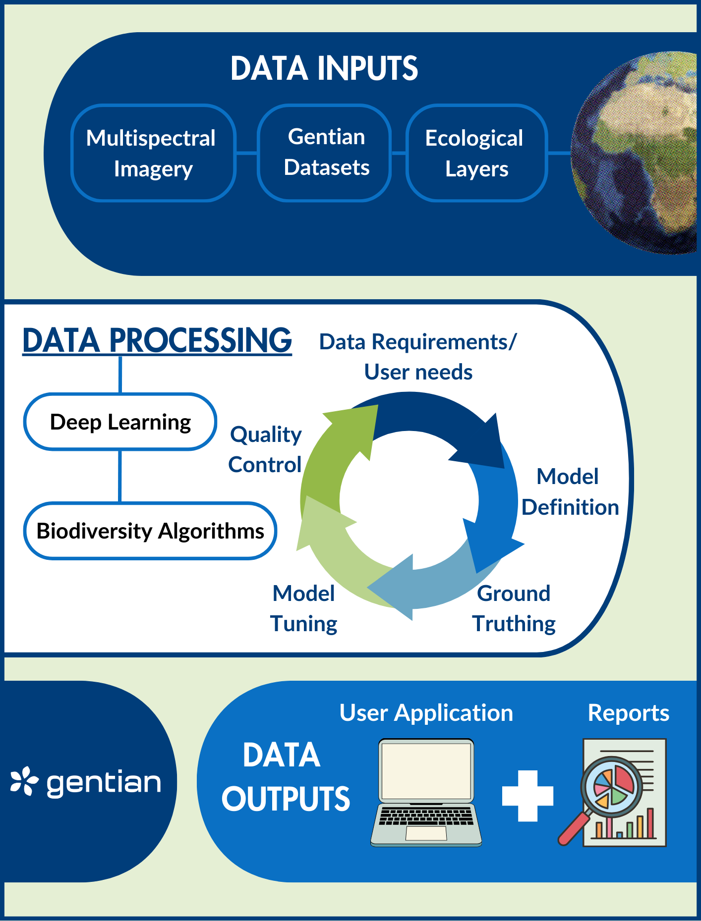
Data is provided as ready-to-use via an online platform, from where it can be viewed or downloaded for ingestion into other data platforms.
-
Reports summarise the actionable insights in the form of easy to use tables and graphs.
-
Maps can be viewed using an online platform that is provided.
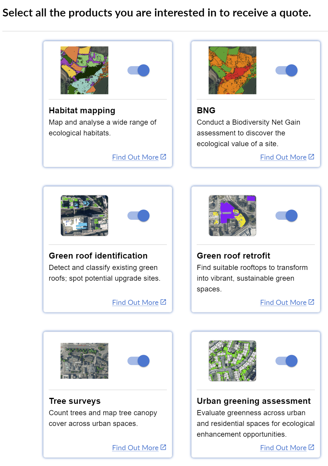
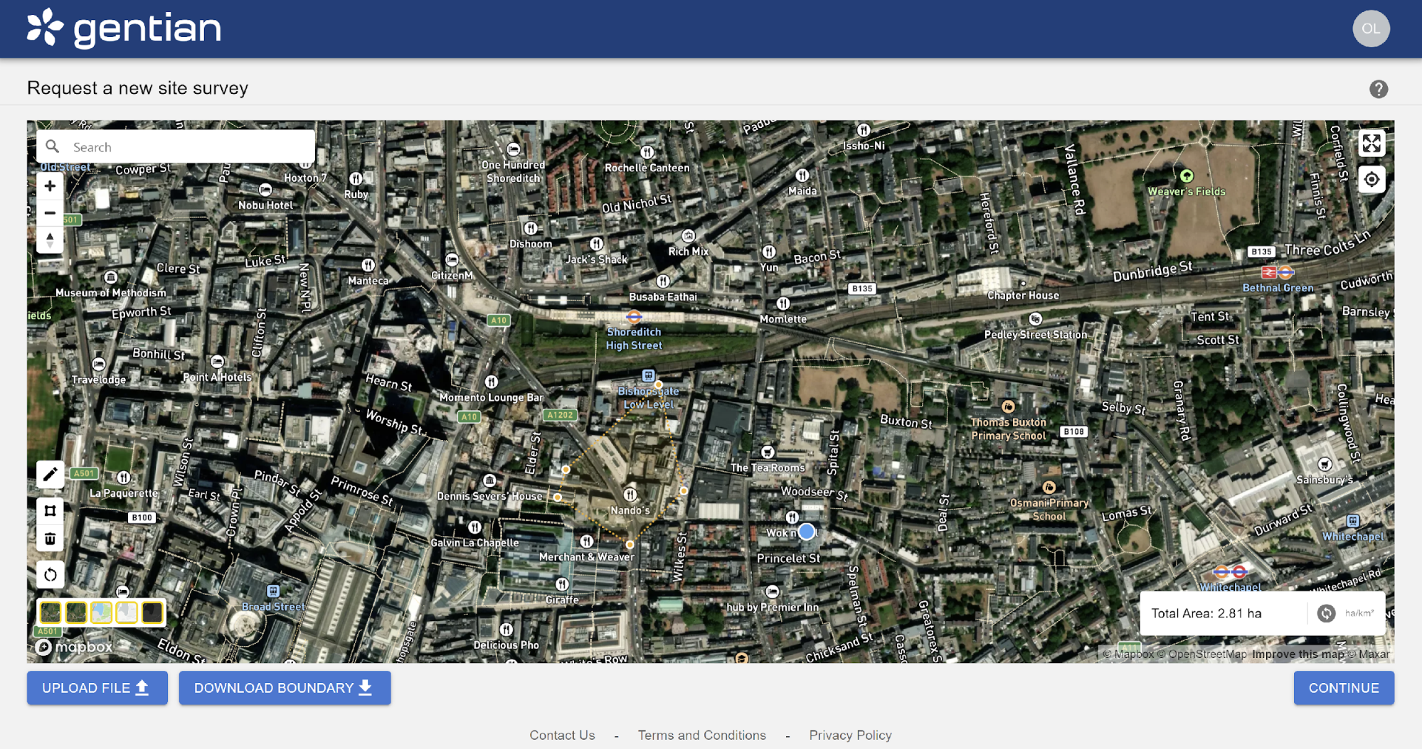
Gentian’s online platform provides a quick and easy way for a customer to obtain an ecological survey. Available 24/7, customers can create an account and then can draw a polygon defining the site and request the type of assessment they require (which will vary depending on whether it is an urban or rural location).
Customers can request the service and select the type of remote assessment options that are applicable to their needs.
Space Added Value
Utilising satellite imagery allows Gentian to monitor sites at a massive scale without traditional manual surveying and given the increasing cost effectiveness of acquiring satellite imagery, measuring Earth from space is not uncommon.
Furthermore, alternative solutions for measuring and monitoring biodiversity also exist. However, to date, these solutions have used low resolution synthetic aperture radar or high quality photographic imagery to assess land use, providing approximations of the extent/type of habitat with limitations. New services entering the market are predominantly based on in-situ soil samples or installation of equipment for acoustics or pest traps. While these methods can generate valuable information, unlike remote imaging, the scalability of these solutions remain limited. Furthermore, logistical challenges and inconsistencies in the calibration of equipment can arise.
Given the immediate action required to address the biodiversity crisis, quickly acquiring satellite imagery and automating assessments using AI presents an opportunity for dramatically expanding our understanding of habitats. Moreover, Gentian’s unique approach to assessments - using vegetation (flora) as the basis for assessments - produces surveys with a comparable accuracy to manual surveys and a service that can be adapted to client needs, habitat and species of particular importance, and the habitat classification systems/reporting frameworks required.
Current Status
Gentian is currently at a pre-commercial stage and is starting to scale-up activity, delivering assessments over larger areas and in shorter timescales. Gentian completed one survey of a site of 1200ha in S.W England in 24 hours and surveyed sites of several hundred hectares in France and the Indian Ocean.
Gentian has held meetings with numerous prospective clients, existing clients, previous clients, and other relevant individuals to understand user needs and validate assumptions about Gentian’s key users. Having gathered extensive information on pain points and user needs, Gentian is in the process of synthesising this information into a comprehensive guideline on Gentian’s current and future customer base.
We have been nominated for the EarthPrize 2024, and have been finalists in a number of other prize awards, such as the Alliance for Sustainable Building Products Innovation Prize (ASBP), and we are working with standards institutes and sustainability leadership organisations on mainstreaming tools for biodiversity reporting.
Gentian is actively conducting customer discovery and preparing to user test the prototype of the online platform.