Objectives of the service
Infrastructure monitoring has been a hot topic in recent years: several cases reported in the news let us know that there’s a clear necessity - both at the institutional and the industrial level - for a faster and more efficient solution to the main infrastructural problems.
Monitoring of infrastructures like bridges and viaducts is currently carried out only during the building phase, to measure the reaction of the infrastructure to various stress factors (passages of heavy-load trucks, movements, etc.) or, occasionally, for structural tests during the life of the manufact. Continuous monitoring (during the whole operating life) seems still a far-from-being-understood aid to early-warning and damage prevention.
In response to this scenario DINAMO is an integrated solution of dynamic and static monitoring techniques supported by Earth Observation data (SAR and optical imagery), GNSS system with a wireless sensor network, hybrid telecommunication solutions (satcom), and geographic information systems (GIS).
DINAMO is a multi-sensor multi-temporal platform representing an operational tool designed for the early-warning and detection of possible structural failures designed with the purpose to provide a solution to the growing need of reliable and durable operational tools for bridges and viaducts continuous monitoring.
Users and their needs
More generically DINAMO customers/users are:
-
critical infrastructures owners (e.g. MIT, ENI, ENEL),
-
critical infrastructures managing authorities (e.g. Highway concessionaire),
-
engineering companies providing monitoring services
User needs:
-
Dynamic and Static Monitoring of the Asset (e.g Asset Viaduct)
-
Data tampering prevention
-
Certifying data with a certified dispositive
-
ensure blockchain service continuity through SatCom
-
Users need to get fast and secure access to the platform
-
User needs to be able to access the data continuously and without interruptions
-
User needs to be able to compare the monitoring data with an updated theoretical model of the infrastructure
-
Users need to gain access to the platform through a user account
-
the user needs to be able to obtain simultaneous multiple access to the platform
Countries of the targeted users: Italy
Service/ system concept
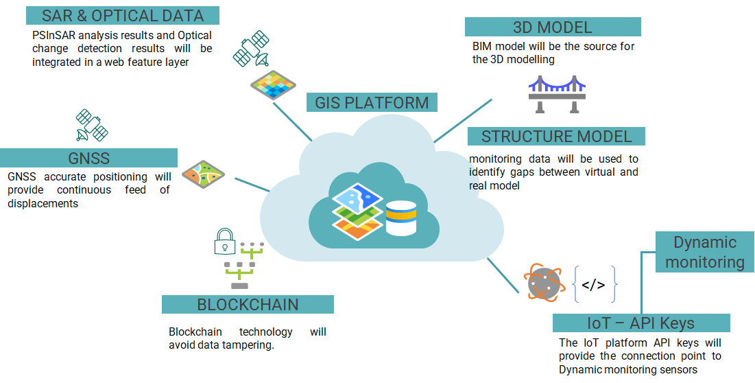
DINAMO solution is based on a Decision-Making Dashboard (DMD) designed with a user-friendly approach that allows access to historical infrastructure data, management and analysis of large amounts of geospatial data without the need for specific technical skills from the user, with the support of a professional GIS platform.
The DMD provide a certain number of tools to access the infrastructure input data, query the sensors and SAR analysis, launch the monitoring analyses for displaying the output data and for the generation of a periodic analysis report.
The Dashboard discriminate SAR analysis concerning the bridge/viaduct from its surroundings. The SAR data on the structure is used to confirm and validate the sensor data while those on the surrounding environment will be used for monitoring the subsidence phenomena and to update the interface of the numerical model in order to avoid a misinterpretation of the results.
Dinamo solution is a modular-structured service integrating the following functionalities:
-
A PSinSAR module
-
GNSS - IoT sensors and controllers.
-
Ground sensors and controllers
-
Numerical FE Model of the bridge/viaduct
-
3D modelling of the bridge/viaduct derived by instrumental reliefs, as an alternative to the BIM model of the infrastructure
-
Blockchain module for secure communication protocols.
-
Optional double communication channels (terrestrial-mobile and satellite) to guarantee transmission in case of emergency.
Space Added Value
Space technology / space asset(s) used by DINAMO SOLUTION:
-
GNSS for continuous static monitoring to be integrated with the dynamic monitoring.
-
SatCom to implement a “service continuity” capability (selected after trade-off among Immarsat, Athena Fidus and Iridium)
-
SAR Imagery (Sentinel1) and more specifically PS techniques for integrating displacement measurements with the GNSS ones. Interferometric Synthetic Aperture Radar (InSAR) and Persistent Scatterer Interferometry (PSI) are in fact consolidated methodology capable of monitoring surface deformations, however with respect to GNSS, which has punctual and continuous monitoring characteristics, the SAR will integrate the GNSS-based information with a more spatial view of the geophysical situation awareness regarding the bridge/viaduct surroundings.
-
VHR Optical Imagery which will be used as a basemap to have an updated picture, a contextual map of the more recent bridge/viaduct’s territory background situation awareness as well as to monitor changes in the surroundings.
Current Status
Pilot in progress