
It may come as a surprise to learn how many kilometers of oil and gas pipeline are buried under our feet: worldwide there is a total of some two million km; for the EU alone there are 180,000 km, of which 140,000 km for gas, the rest for oil and related products. These numbers pertain only to transmission pipelines, the backbone of the system; they do not include the final distribution lines to our homes and places of work. In most cases, this network is not very deep; just 1.5 meters below the surface.
For the pipeline operators, reliability is of course important, but safety is paramount. Pipeline accidents tend to be high-impact incidents that can put people and the environment at great danger, as well of course as damaging the pipeline itself.
In Europe, the main cause for failures in high pressure gas transmission pipelines are what are called Third Party Interferences (TPIs). According to the European Gas Pipeline Incident Data Group (EGIG), TPIs are responsible for almost 50% of all failures in high pressure gas transmission pipelines. Examples of TPIs are excavations, construction activities, and deep ploughing.
Until now, the most common strategy for preventing TPIs is aerial surveying using helicopters. Operators inspect once every one to three weeks the total length of their pipeline route from the air. However, according to EGIG, 37% of safety incidents are detected by the public and only 17% by inspection surveys. In order to improve the effectiveness of the latter, the Dutch company Orbital Eye has developed a novel system to monitor gas and oil pipelines from space.
Following a feasiblity study supported by ESA under the Integrated Application Promotion (IAP) programme, a consortium led by Orbital Eye decided to embark upon an IAP Demonstration Project with the aim of developing and testing a new service in collaboration with two pipeline operators, Gasunie (NL) and PPS Pipeline Systems (NL, BE). Based on inputs from the operators, the team identified three key requirements: the first was detecting TPIs, the second was detecting ground subsidence, which if undetected can lead to structural failures in pipelines, and the third was providing field personnel with access to a database of detected events, so that they could intervene rapidly in case of emergencies.
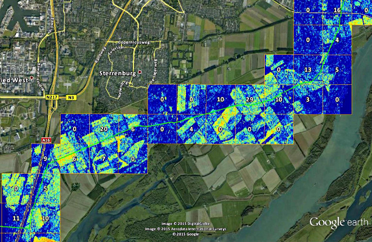
During the course of 2014, a prototype service was set up by the consortium. By processing Synthetic Aperture Radar (SAR) data, the system could monitor pipelines from space, with third-party interference detected thanks to a smart algorithm and ground motion measured to an accuracy of millimetres.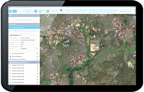 All suspicious events are made available to the pipeline operators route safety teams, which investigate the reported issues. Field personnel carry a PIMSyS tablet that is connected to the operator’s incident database, by cellular network and satellite communications, allowing the device to operate in remote locations, such as desert areas. The tablet app displays an intuitive Geographical Information System (GIS) where the locations of incidents are highlighted.
A service like PIMSyS depends on affordable Earth Observation data, and that is where the EU Copernicus programme enters the picture. Copernicus offers free high-quality EO imagery produced by a growing constellation of Sentinel satellites. Of particular interest to OrbitalEye is Sentinel-1A’s SAR imagery, which offers very high resolution data. Unlike optical systems, SAR satellites can collect imaging data day or night, independent of weather conditions.
“We have been using Sentinel-1A imagery since the satellite was launched, and the results have been very positive”, says Jan Ridder, Managing Director of OrbitalEye. “Currently the Sentintel-1A SAR data is refreshed on average once every 12 days. Initially some operators would prefer a higher frequency, but once they start using the system they find that the current rate is adequate in many cases.” Ridder says that the company is keenly looking forward to the launch of Sentintel-1B, currently scheduled for 22 April; once that satellite is fully operational, the service should provide SAR data more frequently and hopefully also for larger regions, including Asia, Africa, and the USA, allowing OrbitalEye to expand its service offerings.
As part of the IAP activity, PIMSyS was used in live conditions by Gasunie and PPS during 2015. The trials were successful and the two pipeline operators are planning to adopt the monitoring system. “Pipeline operators, like many large organisations, tend to be conservative and risk adverse. There is a high threshold for getting your foot in the door with a new service,” Ridder says. “Thanks to the support of ESA through the IAP Demonstration Project, we were able to deploy the PIMSyS system for these two operators, thereby gaining real-world experience. This was absolutely critical for gaining the trust of new customers in this industry.”
OrbitalEye has now been contracted by a major African pipeline operator to provide monitoring services. OrbitalEye expects more customers for its satellite-enabled service in the near future.
“PIMSyS is an excellent example of the strength of ESA’s IAP programme,” says ESA's Olivier Becu, the Technical Officer for the activity. “IAP gives promising start-ups such as OrbitalEye the opportunity to develop and deploy new space-based services in an operational setting in order to validate their solutions together with users.”
![]()
For more information about PIMSyS, contact Orbital Eye.
Image credits: Orbital Eye