
Objectives of the service
Amphitrite provides a new service to the shipping sector in order to reduce fuel consumption and CO2 emissions without changing their vessels or fuel. Our ocean bulletin provides a new maritime routing mode thanks to innovative Met-Ocean data that contains high resolution surface currents (HIRES-CURRENTS). Such reliable ocean data makes short-term routing optimization possible. In standard weather routing, the main target is to avoid the big storms and bad sea state. The aim of short-term optimal routing is to look at a smaller scale, so as to position the ship correctly, avoiding head-on currents and taking advantage of carrying ones.
Users and their needs
Shipping currently accounts for 3% of global greenhouse gas emissions. Today, every ton of avoided CO2 count! Regulatory and societal pressures on shipping companies are increasing.
Route and voyage optimizations are solutions that can be used right away. These are win-win solutions because by reducing the fuel consumption of merchant ships they simultaneously reduce CO2 emissions and operating costs. Both shipping companies and solution providers can deploy a short-term optimal routing solution thanks to the high-resolution and reliable ocean data we provide.
Service/ system concept
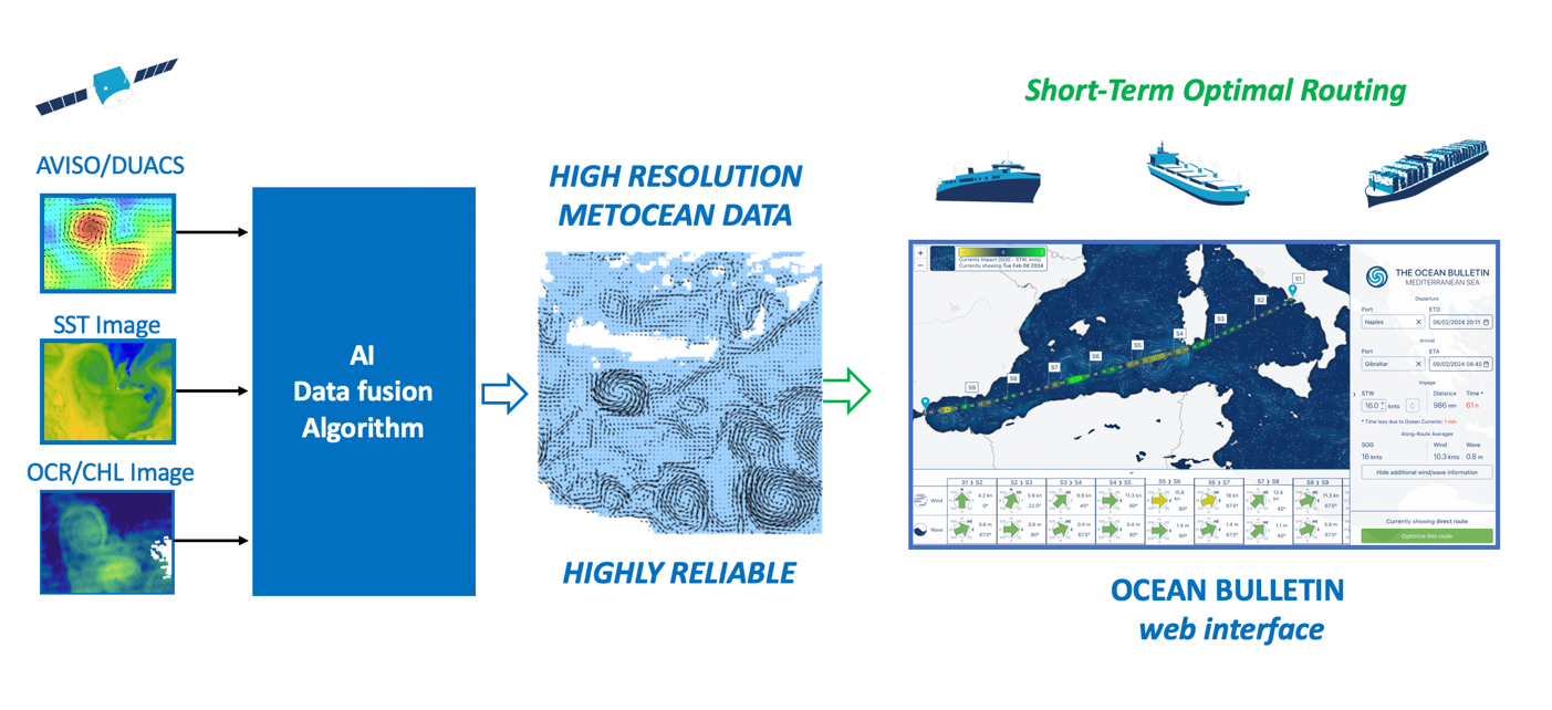
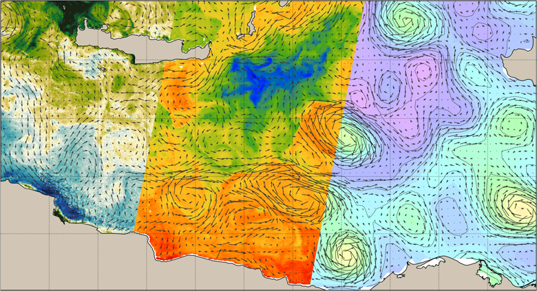
We produce high-resolution surface currents, calculated in real time thanks to multiple satellite observations of the ocean surface: infrared and visible imagery combined to altimetry maps. These HIRES-CURRENTS data combined to standard meteorological forecast enables short-term optimal routing for all commercial vessel via our interactive web interface or any routing software used in the maritime industry.
Space Added Value
This innovative technology of data fusion, the fruit of several years’ research, is based on advanced AI computer vision. We can fuse multiple satellite data with different physical variable and resolution such as: chlorophyll images, sea surface temperature and altimetry maps. The input satellite data we used are part of the Earth Observation program of ESA (Sentinel 3 and METEOSAT) or NASA (VIIRS and ABI).
The new generation of ocean data that we provide and especially the surface currents are far more reliable than the outputs of operational numerical models which are currently used in standard weather routing. We gain up to 45% in reliability which enables high-performance oceanic routing.
Current Status
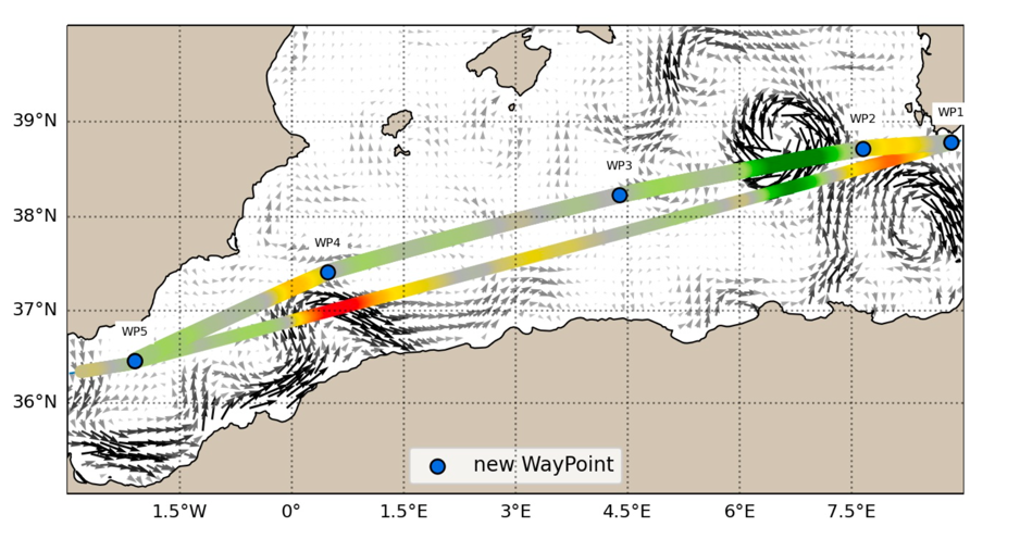
Thanks to this project, supported by ESA, our technology was tested and validated by a French shipping company and short-term optimal routing becomes a reality! On April 8, 2023, following the Ocean Bulletin provided 24 hours in advance by Amphitrite, the Ro-Ro vessel Ciudad de Cadiz, equipped by the Louis Dreyfus Armateurs group, deviated a few dozen nautical miles north of the direct route between Sardinia and the Strait of Gibraltar to avoid counter-currents and benefit from positive currents. This short-term optimal routing, based on ocean currents, enabled the Ciudad de Cadiz to save 70 minutes on its route, and ultimately reduce the ship's consumption by 5% over 36 hours, while maintaining its arrival time at the destination port. The potential fuel savings for the Tangier-Tunis-Naples-Tangier rotation have been estimated at between 40T and 100T of fuel for around twenty rotations per year, depending on the optimization mode chosen.
Similar savings were found in the Gulf of Mexico for large LNG container, according to the data send by GTT-digital.
Thanks to the high frequency navigation data provided by CMA-CGM we were able to quantify precisely the impact of the oceanic currents on the ship speed (Speed Over Ground) and to compare our forecast with other data source. Here again we demonstrate that the accuracy of our HIRES-CURRENT data, goes far beyond standard ocean forecast (MERCATOR and MFS) in the Mediterranean Sea. The standard models forecast could reach a relative error of 72% on the intensity of strong currents while for our HIRES-CURRENT data these errors drop down to 35%.