
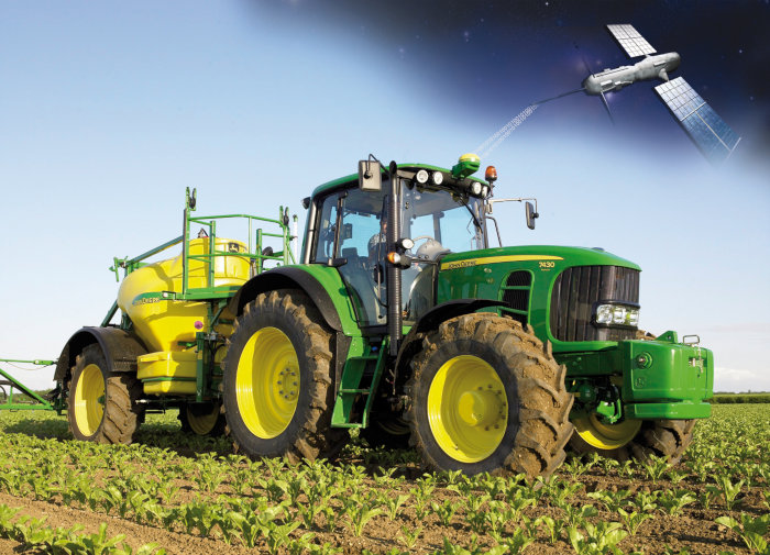
Reducing the risk of bird strikes using satellite images and Ascend’s Normalised Difference Water index software (NDWI)


BROWSE PROJECTS
Based on user needs and industry skills, the evolution of customized solutions and the establishment of innovative services is accomplished through project activities. Focusing on various thematic areas, relevant information on the project activities is provided below.

CORISCLIM
Status date: 08 April 2024
Rapid Assessment of Future Coastal Flood Risks Around the World To Build Coastal Resilience
Digital Port Platform
Status date: 07 May 2024
The Digital Port Platform is a Hub of maritime modules to improve port operations and lower their environmental impacts.
This Hub gathers space assets and other sources of data to transform them into key indicators thanks to advanced AI technologies.
It allows real-time situational awareness to solve major environmental and performance issues.
PLESS DEMO
Status date: 07 May 2024
Provide a brief description of the project in less than 60 words.
It will not appear on the project web page itself but is used in project lists e.g.
https://business.esa.int/projects and search results.
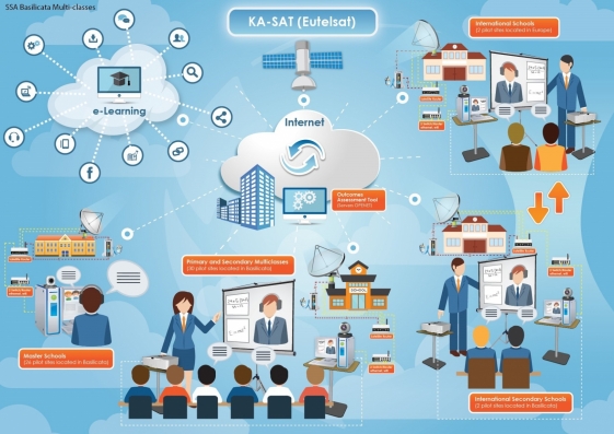
ONE CLASS!
Status date: 22 April 2024
ONE CLASS! is a “ONE STOP SHOP SATCOM-BASED SOLUTION” conceived to foster the use of distance learning in isolated schools/areas, to assist children hospitalized for medium to long-term stay, to support the multiclasses needs and facilitate social integration actions for Foreign Unaccompanied Minors (FUM) needing access to education and social inclusion programmes. Via a project extension (CCN3) a new service is added, providing a rapidly deployable packaged solution for education in emergencies, provisioned with telecommunication systems (“Portable Learning Space (PLS)”. The idea is to conceive, develop and operating a “one stop shop solution” offering to emergency context the opportunity to have a “classroom in place” completely equipped with Information and Communication Technology (ICT) devices and provisioned with an integrated telecommunication system (satellite, mobile, 5G) to start the process of social and cultural integration thanks to the access to digital educational and civil/cultural-oriented contents.
Data4Water
Status date: 20 May 2024
Data4Water addresses the intricate water challenges in India's Godavari River basin, a priority basin for the Water Resilience Coalition. The project aims to enhance water management by providing accurate river discharge forecasts through BWI’s services for various sectors. Targeting farmers, agribusinesses, and local authorities, the project seeks transformative solutions for the basin's diverse water-related issues, offering a holistic approach to address uncertainties, fluctuations, and climate impacts.
APPIDE
Status date: 06 May 2024
APPIDE is an AI-powered tool designed to increase the efficiency of thermographic inspections of photovoltaic plants (both ground- and roof-mounted). Using radiometric, RGB, and GPS data acquired from drones, APPIDE generates detailed reports in a matter of hours, identifying exactly where and what the performance problems are on solar sites. Our AI-based solution drastically reduces the inspection times by human inspection and increases the reliability of reports. Overall, APPIDE allows you to make more inspections with fewer human resources, maximising the return on investment of your drones and your business.
MIRORES
Status date: 30 April 2024
MIRORES consortium launches a geological prospecting-consulting company focusing on space resources. The expertise is built around a proprietary far-IR spectroscope for remote detection of sulfide and oxide ores containing key resources for planetary ISRU (titanium, iron, oxygen, sulfur, PGMs and energy resources - pyrite and helium-3). Proper supply of these resources is also essential for Earth’s transition into zero-carbon economy.
SatADAPT
Status date: 30 April 2024
SatADAPT is a Predictive Maintenance system based on vibration monitoring and AI. The system consists of wireless vibration sensors which send data to an AI engine in the cloud which is also replicated onto Edge devices. The AI looks for anomalies in the frequency spectrum and warns of potential failures, classifies the expected defects, and estimates the time to failure.

Scope 3
Status date: 22 April 2024
Measuring and controlling GHG scope 3 emissions is crucial for the chemical industry goal of achieving carbon neutrality by 2050. Reliable monitoring mechanisms built from precise, trusted data, allow to calculate their precise product carbon footprints, and conduct truthful life cycle assessments. Scope 3 services fully cover the evolving needs from the industry with a user-friendly monitoring and simulation platform specialized on multi-modal transport emissions.

Greener Cotton
Status date: 26 April 2024
Greener|Cotton aims to substantially improve sustainable cotton production by the application of satellite based digital agriculture technology. Integrated with cotton local traceability solutions, Greener|Cotton will help to reduce inputs and thus costs, allow to better manage production risks, reduce workers and environmental contamination, increase cotton quality, yields and revenues, lead to trusted production data and improving smallholder livelihood.
EXTENSION
Status date: 26 April 2024
The project aims at the creation of services for the safeguard, conservation, promotion and enjoyment of the cultural heritage by using Space assets, AR and 5G network. The initiative has as its principal user the Municipality of L’Aquila, whose heritage is willing to be prevented and enhanced thanks to the development of the app, major outcome of the project Extension.

GeoInsure
Status date: 26 April 2024
GeoInsure is a fully operational, custom designed, state-of-the-art Earth Observation based geospatial tool, specifically build to be seamlessly integrated into the operational workflow of a company active in the (re)insurance market, with an emphasis on natural catastrophes (Nat Cat) and extreme weather events insurance and reinsurance activities.

TSMF_10CM DP: WaldCursor
Status date: 19 April 2024
TSMF_10CM DP is Tama Group’s core project to develop, test and test market the WaldCursor product. The project covers development, test and field test of a cloud & app based remote sensing analytics information platform for forestry and environmental applications.
TEMIS
Status date: 19 April 2024
Massive end-to-end IoT satellite services, fully operational in GNSS denied environment and very robust to jamming & interferences for highly scalable applications in numerous verticals such as logistics, transport, agriculture/smart farming, maritime, environmental, mining/oil/gas, smart cities, smart building, e-health, utilities, industry…
WaterSIM
Status date: 18 April 2024
Water is an essential resource under multiple stress factors, and stakeholders encounter difficulties to set up and maintain a performing integrated management of water resources and uses. Thanks to space-based tools, WaterSIM service can leverage several issues & drastically improve the performance for monitoring and controlling the water cycle of rivers and reservoirs and its healthy/unhealthy state to support decision-making.
ABLE ACTIVE
Status date: 17 April 2024
ABLE ACTIVE promotes accessible trails and amenities to people with disabilities, uniquely by disability. Feedback captured from users helps to inform and inspire, making it easier for others to find opportunities suitable for their specific needs, and helping amenity operators to better understand and support their user community.