
Objectives of the service
Use a bold image to start your webpage. It can be a photo or an infographic like this. Remember that you project webpage can be a powerful marketing tool.
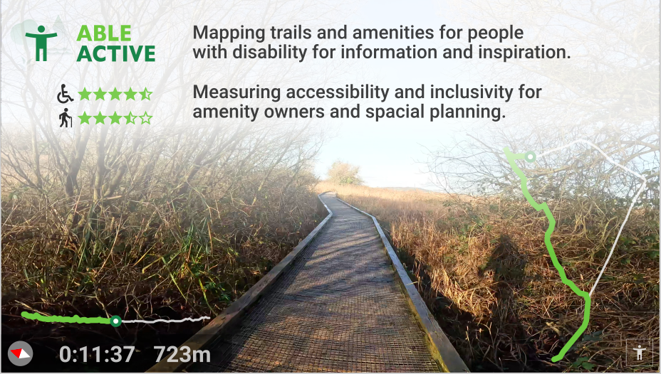
People with disabilities often want to be more active, especially outdoors, but are challenged to find trails and amenities suitable to their particular needs.
Able Active brings a disability-centric focus to locating and participating in outdoor activities, capturing feedback on accessibility and inclusivity based on their experiences and disabilities.
Using the app, users and group leaders can record their actual trails using GNSS location capture, as a long-term record and as the basis of repeat activities. Amenity operators can extend this capability to commission a promotional video to visually communicate trail details, including surface types, inclines, obstacles and facilities.
Feedback from users helps amenity operators better understand their users’ needs, make and measure improvements and simplify impact reporting to third-party funders.
Infrastructure planners benefit from an accountable GIS dataset which describes amenity usage, locations and time patterns to target investment and demonstrate impact.
Users and their needs
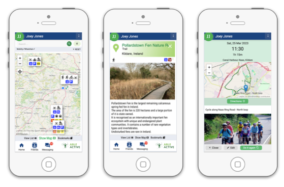
ABLE ACTIVE is for users living with a disability, or their guardian, carer or support organisation, simplifying the task of finding trails or amenities suitable to their specific individual disability and offering an easy way to record how well the facility met their needs.
Key needs identified:
-
Clear an peer-validated information, for their disability
-
Location of facilities, including disabled parking, toilets, etc.
-
Ability to record and replay their own route
-
Ability to submit feedback to the amenity operator
-
Ability to organise group activities
Amenity Operators use ABLE ACTIVE :
-
to maintain an accurate profile, including events, tours and competitions
-
to showcase their investment and commitment to accessibility and inclusivity
-
to engage with user feedback, and quickly respond to issues and hazards
-
to better attract visitor groups which include people with disabilities
Sports organisations use ABLE ACTIVE to highlighting their commitment to an inclusive experience and to identify opportunities to promote their sport to a wider audience.
Municipal and government bodies use ABLE ACTIVE as an integrated platform to bring consistency for users in their regions, for measuring accessibility on existing datasets and for measuring impact in real-time.
Service/ system concept
ABLE ACTIVE is published as a mobile app for iPhone and Android, connected to the cloud-based platform, which in turn manage user data, communications and integrations. The solution includes a website plugin with allows selected records to also be presented on websites, typically for an amenity operator or equipment supplier.
Formal trails and amenities datasets, published as part of government ‘open data’ policies, are integrated and inter-linked with live data feeds for weather, alerts, tides, daylight hours and locations of safety equipment to provide a rich baseline of authoritative information for all users.
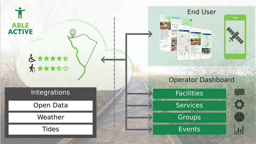
ABLE ACTIVE combines cloud-native technologies in a purpose-built platform to efficiently delivery content to the user according to their preferences and their Mobile GNSS location. The solution includes well-defined APIs for integrations with external platforms and additional data sources.
Space Added Value
ABLE ACTIVE uses Mobile GNSS to identify user location and elevation, to provide context awareness to search results, their progress on a planned route, location specific weather and safety notices and, in particular, to record their route using their mobile device as a record of their activity or to use as the basis of a future outing, especially valuable when researching route suitability for groups of disabled participants, where unforeseen or undocumented hazards can negate the otherwise positive potential of the activity.
These tested routes can be shared on the platform, subject to a validation process, to disseminate opportunities available to people with disabilities with the required level of detail.
ABLE ACTIVE also offer a service to combine video with such a recorded trail into a “walkthrough video” which highlights aspects such as surface types, lippage, gradients, trail widths, points of interest, etc., to further inform the user and to promote the operator’s investment in accessibility.
Current Status
ABLE ACTIVE is available for download on Apple App Store and Google Play Store and includes the following capabilities:
-
Access to trails, trailheads, and beaches in Ireland;
-
Provide feedback on amenity to include accessibility rating and hazards;
-
Bookmark, Like, Share favourites;
-
Forward scheduling to include weather forecast, daylight hours and tides (for coastal locations);
-
Record and reuse their own trail;
-
Connect with friends and family;
-
Contribute to data, for example, disabled parking locations at trailheads.
Operator dashboard provides for management of and reporting on amenities, trails, facilities and services, as well as the listing of upcoming events. Operators can securely respond to feedback through the platform.
