ESA title

"CSP-FoSyS" activity, second phase started!

Courtesy of Solar Millennium AG

Did you know that the energy coming from the sun everyday and reaching the surface of the Earth is equivalent to 60,000 times the worldwide energy consumption per day? The potential of the sun to cover the world’s electricity needs is immense, but it is not equally distributed, depending on the area of the globe and the meteorological conditions, whereas the areas with better solar resources are not always the largest electricity consumers.

Courtesy of the DESERTEC FoundationAs an example, Dr. Gerhard Knies, chairman of the Supervisory Board of the DESERTEC foundation, explains us:

- “Within  6  hours, deserts  receive more  energy  from the  Sun than humankind consumes  within a  year. But how can this radiant energy be economically transformed into useful energy and transported to consumers?” 

Even with this limitation, huge investments are made in solar transducer technology like photovoltaic panels, parabolic-through reflectors, solar towers etc.

courtesy of GreenTerraFirma

In the short term, considering the current status of the technology, Concentrating Solar Power technology (CSP) based on parabolic through reflectors is seen as one of the clearest options for the future, as it allows the generation of electricity on large scales. Sunny regions of Europe are experiencing the deployment of the first of these power plants, supplying energy to their surrounding areas. Solar Millennium AG together with partners has developed, designed and realized Europe’s first CSP power plants, located in the region of Andalucía, near Granada, Spain, and they describe us their working principle:


courtesy of Solar Millennium AG- “The technology is based on the concentration of direct solar radiation using parabolic-shaped mirrors.” says Benedikt Pulvermüller, project manager at Solar Millennium AG. The heat is collected in an absorber tube filled with a heat-transfer fluid.The heat is used to generate steam which is used to run a turbine and to produce electricity as in many other conventional power plants, like coal or gas. The rationale behind this approach is that heat can be easily stored and later used to generate additional steam, particularly during cloudy periods or even at night”

Andasol-1 was designed with a production capacity of 50 MW, allowing a maximum production up to 180 GWh per year. However, radiation received by the power plant is rather variable due to night, clouds or aerosols. In order to optimise the operation of the power plant and take the most out of it, a proper forecasting system is required. There it is where space technologies enter on stage. Data coming from Earth Observation satellites can be used to support standard weather forecasts and local measurement stations, while satellite telecommunications can make all the information from the satellites and the ground stations available in real time, which is a mandatory requirement for the operation of the power plant.

However, if the storage of heat allows the provision of a stable electricity output, why is it necessary to develop a forecasting system? Just because it is not enough to grant stability on a theoretical basis. Electricity grid and market operators have tight requirements of predictability over long periods of time. If renewable energies have to enter into real operation on massive scales, stability is an imperative to avoid a general collapse of the electricity distribution system. Additionally, it will allow the planning of maintenance operations in advance to meet the most appropriate conditions.

The service concept investigated within this activity is going to be tested in the Andasol-3 power plant, currently under construction.

-“If the results are in line with our expectations, we will use the resulting forecasting service to improve the operations of other CSP projects we are developing around   the   world,”   says Benedikt Pulvermüller. “We could  even start  providing these  forecasting services to other  CSP  or  Photovoltaic operators”.

The CSP-FoSyS activity has just started its second phase, and it is run by Solar Millennium, a  company new to the space arena specialised in the development and construction of innovative technologies for solar thermal power plants. They are supported by DLR-DFD and ESA.

Teaser paragraph

Did you know that the energy coming from the sun everyday and reaching the surface of the Earth is equivalent to 60,000 times the worldwide energy consumption per day? The potential of the sun to cover the world’s electricity needs is immense, but it is not equally distributed, depending on the area of the globe and the meteorological conditions, whereas the areas with better solar resources are not always the largest electricity consumers.

TalkingFields - Demonstration Project on Services for Precision Farming started

Sustainable food production and food security are central challenges of this century. Limited acreage and high demand for resources for food and bio-energy production drive up prices. One promising way of solving these problems is to achieve higher efficiency in production via precision farming.

TalkingFields is an initiative intended not only to overcome these shortages but also to provide farmers with affordable and low-time consuming, end-to-end precision farming services to increase production efficiency. TalkingFields is based on a geo-information service that applies satellite-based data sources and techniques in an integrative way.

Satellite sensors from Earth Observation deliver spatial information about the crop development. In- field sensors, where available, measure weather conditions. The farmer communicates the applied and planned farming measures to the geo-data service. An agricultural geo-information service integrates all input data, and translates it into advice on what farming measures are required. The recommended measures are delivered to the farmer, who uses satellite navigation for auto-steering and realisation of these site-specific farming activities.

The feasibility of this integrative application of space techniques for precision farming was studied in the frame of ESA's ARTES 20 Integrated Applications Promotion (IAP) Programme. The resulting IAP Demonstration Project project has been completed.

Teaser paragraph

TalkingFields is an initiative intended not only to overcome these shortages but also to provide farmers with affordable and low-time consuming, end-to-end precision farming services to increase production efficiency.

"INTOGENER" study launched

What could be the consequences of a poor water management? One might think on droughts, agriculture and farming losses, desertification, but probably one will never think about an energy collapse. And, as a matter of fact, water is used in many energy production-related processes as well as by means of hydroelectricity power plants. The Britannica Encyclopedia provides a concise description of what hydroelectricity is:

"Electricity produced from generators driven by water turbines that convert the energy in falling or fast-flowing water to mechanical energy. Water at a higher elevation flows downward through large pipes or tunnels (penstocks). The falling water rotates turbines, which drive the generators, which convert the turbines' mechanical energy into electricity."

Hydroelectricity belongs to the category of renewable energies, being the most developed and mature technology inside this group. It is a relevant component of the electricity mix of countries with relevant hydrological resources like Canada, Brazil, Argentina, China, Chile, Russia and U.S. Even more, it represents more than 90 % of the power generated in countries like Norway or Iceland (source: IEA - Hydropower Agreement, http://www.ieahydro.org).

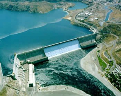
INTOGENER (INTegration of EO data and GNSS-R signals for ENERgy applications) focuses in the case of Chile. ENDESA, a Spanish utility owned mostly by the Italian Enel Group is de facto the largest utility in South America, being Chile one of the markets they operate. In Chile, more than 40 % of the national electricity mix comes from hydroelectricity power plants, being most of them located in the central area of the country. For the management of the power plants, all the utilities use currently a statistical model of the region. It is based on a limited set of in-situ measurements as well as previous years’ meteorological and hydrological information. The accuracy of the outcomes of this model differs up to 60 % with respect to reality. ENDESA is willing to find an alternative that can help them to manage their power plants in a more efficient way. Over the past decade, the electricity demand in Chile has grown at an average rate of 7 % per year, making mandatory an optimisation of the hydroelectrical resources in the short term to avoid further investment in fossil sources to fill the demand.

Copyright Starlab

Due to the peculiarities of the Chilean area (dominated by the high and not very accessible Andean mountains), space technologies can provide information for example, concerning the snow & ice coverage (SAR data) water flows and temperature (IR-Thermal data). The installation of low-cost GNSS-R devices in strategic locations can provide relevant information concerning water basins levels. On top of that, satellite communications can be used to send data acquired from these devices and data loggers, like soil moisture measuring equipment, to a processing centre where a new discharge model of the area of interest will be running. The combination of the model plus the mentioned inputs will be the basis of a service aimed at the improvement of ENDESA's management capabilities of their resources in Chile.

The recently launched feasibility study is run by Starlab, a Spanish company in close collaboration with ENDESA. Starlab and ENDESA worked in together in the past, and the present concept under analysis has come as a result of that partnership.

Teaser paragraph

Hydroelectricity belongs to the category of renewable energies, being the most developed and mature technology inside this group.
However, could space technologies help the management of hydrological resources to improve the capacity of existing hydroelectricity power plants? ESA has just initiated the INTOGENER feasibility study to look into this topic.

Symposium €œHumanitarian Demining 2010

Landmines and Explosive Remnants of War (ERW, e.g. cluster ammunition) are a threat to human life and economic development of nations emerged from conflicts. Land Release in Mine Action is a staged process of ever closer investigation of suspected hazardous areas, aimed at discriminating between uncontaminated and truly contaminated areas. The former are directly released to the population, while the latter are cleared (i.e. explosives are removed) before release. Within a given budget the objective of land release is not so much to find and remove as many mines/ERW as possible, rather to achieve a maximum socio-economic benefit for affected populations. Therefore priority setting is a critical aspect of land release efforts. Using the most cost efficient tool to achieve a given objective along the land release process is also essential. By providing the proper information, in a timely manner, anywhere it is needed, space assets could significantly benefit land release actions.

The Internal Symposium for Humanitarian demining took place on April 26th -29th 2010 in Sibenik, Croatia. It was co-organised by the Croatian Mine Action Center (CROMAC) and Center for Testing, Development and Training (HCR). This annual event is one of the major gatherings of the demining community. ESA participated in the event to outreach about the benefits of space assets for mine action. It was also an opportunity to make the audience aware of the open tender. A plenary presentation showing highlights of the feasibility study ITT was delivered by ESA.

This presentation, together with the paper supporting it can be retrieved here.

ESA also co-moderated a workshop on the use of new technologies as decision support in defining Mine Suspected Areas.

The conclusion of this workshop are provided here.

Teaser paragraph

The ESA IAP team actively participated in the 2010 International Symposium on Humanitarian Demining, Sibenik Croatia. It presented highlights of the open tender for a feasibility study on "Space Assets for Demining Assistance" services .

Bird Strikes Risk Reduction for Civil Aviation study launched

*Picture copyright: Adam Samu

Are bird strikes are a serious threat for civil aviation safety?

Having a look to reports done by international organisations, it can be deduced they are quire common: Over 87,000 bird strikes to civil aircraft in the United States were reported to the Federal Aviation Administration (FAA) from 1990-2008, a mere 20% of the number that likely occurred (source: http://www.birdstrike.org). Although these figures seem to be high, Civil Aviation authorities as well as airports are prepared by having existing procedures for reducing bird strike hazards at and near airports but any effective strategy against bird strikes shall include their prevention as one of their main objectives.

It has to be said that bird strikes are an issue as old as aviation, but their significance as a hazard has not been diminished along the years. The question people might have is why so? A pilot of a commercial airline gives us his opinion:

Image courtesy of Mr. Orry Dryver
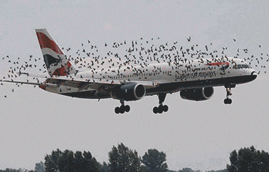
Natural selection has taught birds to wait until the very last moment to turn in order to avoid predators. This has to be done in this way, because if they move before, predators will be still able to turn and catch them. Nowadays, as planes are becoming faster and more silent, birds, perceiving planes as possible predators, do not really have enough time to turn, and therefore, got struck by aircraf

Hazards associated to bird strikes are of mandatory consideration by Civil Aviation, as it is clearly stated in Annex 14 of the SARPS (ICAO's Standards and Recommended Practices): 

The manual containts SARPS Annexes 6, 10 and 14 for runaway incursions

When a bird strike hazard is identified at an aerodrome, the appropriate authority shall take action to decrease the number of birds constituting a potential hazard to aircraft operations by adopting measures for discouraging their presence on, or on the vicinity of, an aerodrom 

However, apart from the elimination of rubbish disposal dumps near airports, Annex 14 of the SARPS does not provide any kind of specific measures to be taken, leaving authorities the freedom to manage the situation. Obviously, this situation results on a disparity of non-standardised techniques used depending on the available resources, budget, situation and priority given by the relevant authorities.

Despite the current variety of prevention techniques used, is it possible to increase the overall performance by combining existing assets with space technologies without endangering airport operations?

European Space Agency has just started the Bird Strikes Risk Reduction for Civil Aviation study to address specifically this issue.

The overall idea of ESA is to create partnership with relevant users and stakeholders trying to identify if the integration of space technologies with current existing assets can cover identified gaps in the overall bird strikes prevention strategy and if it can provide any added-value with respect to present approaches.

Civil Aviation is composed of a multitude of bodies, including authorities, airport operators, air traffic controllers and pilots amongst others. One of the challenges of the study is to identify the bodies and even the units inside these bodies that could take advantage on the utilisation of this information as well as practically using it.

When talking about Civil Aviation we have to take into consideration liability issues, reports a specialised lawyer. For example, an airport operator's liability is usually dependant on the claimant proving the airport was at fault. In case of accident, passengers are going to make claims against airlines, and these are going to make claims against airport operators.

The legal implications of all the actors involved in the provision of a service it is a risk factor to be considered by anyone willing to provide services to Civil Aviation. 

The feasibility study will run in two phases: First dedicated to the identification of requirements and the analysis of existing technologies and services that could fulfil these requirements. If the results are successful, a second phase of the study will analyse the technical, legal and economical viability together with the liability-related of proposed services built upon these existing assets. The study is carried out by an industrial consortium led by Helios Technology Limited. Manchester, Schiphol and Heathrow airports are collaborating within the activity.

*Picture copyright: Adam Samu 

(http://www.airliners.net/photo/0620854/)

Teaser paragraph

Despite the fact that bird strikes are an issue as old as aviation their significance as a hazard has not been diminished along the years. The European Space Agency has just started the “Bird Strikes Risk Reduction for Civil Aviation” study to address specifically this issue.

Ambassador Platform for IAP in Central & Eastern European Region portal is now on line!

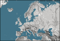
IAP is pleased to announce the starting up of the Ambassador Platform for IAP in Central & Eastern European Region (APCEE) portal. The objective of this Ambassador Platform, managed by the European Space Policy Institute (ESPI), is to assist the IAP programme in spreading awareness for potential stakeholders in ESA's IAP programme, in the region of Central and Eastern Europe. The region of Central and Eastern Europe is a fertile area for development of new satellite based services of direct benefit for socioeconomic development. The IAP programme, which offers opportunities for creating new innovative services utilizing the added value of space assets, can become a serendipitous gateway to meet the needs of the region.

Are you interested? Please visit the APCEE community portal website to know more!

Teaser paragraph

Transform Your Business With Space Technology

Three Universities for Business Event, Leicester, 14th April 2010

Photo - Leicester Mercury newspaper

As part of the iFestival (one of the largest innovation festivals in the UK), ESA-IAP participated in an event bringing together local businesses in the Leicester region with the three local universities of Leicester, De Montfort and Loughborough. The ESA representatives presented the IAP programme, using IAP projects as case studies to illustrate how space-based services can meet a huge range of user needs, across many different industry sectors.

The three local universities each presented a variety of technologies that have arisen from their work in the space domain but which are being transferred into down-to-earth products and services. Many of them are world-leading, reflecting the enormous concentration of space-related expertise that exists in the East Midlands region. More than 70 delegates attended the event, which was held against the backdrop of the UK National Space Centre, culminating in a viewing of the highly successful, full-dome planetarium show, “We are Astronomers”, which was developed at the centre by the NSC Creative Team. The previous day, a smaller workshop focused on applications in the realm of Intelligent Transport, with an audience comprised of representatives of the city council along with academics, business development and technology transfer staff from the three universities in the area. This was hosted by the University of Leicester and was led by the ESA representative Dr Stefan Gustafsson (from the Integrated and Telecommunications related Applications Department, ESTEC) and Alan Brunstrom (Manager of the Ambassador Portal for Enhanced Mobility, based at the new ESA Centre in Harwell).


[ Photo - Leicester Mercury newspaper: from left to right: Professor Roy Kalawasky, University of Loughborough; Professor Eric Goodyear, De Montfort University; Alan Brunstrom, Manager of the Ambassador Platform for Enhanced Mobility (ESA Harwell); Dr Stefan Gustafsson, ESA; Nick Carter, Chairman of Prospect Leicestershire; Professor George Fraser, University of Leicester: standing in front of a Soyuz space capsule in the National Space Centre, Leicester]

Teaser paragraph

Three Universities for Business Event, Leicester, 14th April 2010

As part of the iFestival (one of the largest innovation festivals in the UK), ESA-IAP participated in an event bringing together local businesses in the Leicester region with the three local universities of Leicester, De Montfort and Loughborough.

New On-Board Health Monitor System to be introduced

Tempus-ICEtihad Airways will install new state-of-the-art technology on its long and ultra long haul aircraft which can monitor the condition of passengers who display signs of sickness that might require immediate medical attention.

The "Tempus IC" system, developed in partnership with ESA, allows cabin crew to gather vital information about a passenger's health quickly and efficiently. The data covers a wide range of the passenger's vital signs including blood pressure and an electrocardiogram. It also allows the crew to take photo imagery. 

That information is then transmitted to a medical team of global experts specialised in assistance in in-flight medical contingencies. Following their advice the crew will take a decision about what to do next for the passenger and the flight.

Captain Richard Hill, Etihad Airways. chief operations officer, said: .Passenger welfare and safety is of the utmost importance to Etihad Airways and the introduction of the Tempus IC system will ensure that when medical emergencies do occur they are evaluated quickly. 

"This helps ensure that the passenger can receive the appropriate treatment when the aircraft lands, whether this is as a diversion or at its final destination."

Etihad will introduce the Tempus IC technology, designed and manufactured by UK-based RDT, on its A340 and Boeing 777 aircraft and then subsequently across the remaining long and ultra long haul fleet.

Grahame Fever, Commercial Aviation Sales Director RDT, said: "We are delighted that Etihad has chosen RDT .s Tempus on-board telemedicine technology."

"We know from our existing Tempus customers and the in-flight trials with Etihad cabin crew that Tempus technology, with its unique ease-of-use help screens and features, makes a significant difference to quality and speed of on-board medical care."

Following the successful launch of the "Tempus IC" system, ESA's IAP programme is partnering once again with RDT on a new project, together with International SOS, to develop, integrate, test, and validate a tele-assistance service called Amazon, that makes use of multiple space assets (Satcom, Satnav), for professional clinical users in remote locations using a highly compact device for vital-sign monitoring and remote diagnosis.


About Etihad Airways

Etihad Airways is the national airline of the United Arab Emirates based in the UAE.s capital, Abu Dhabi.   

About RDT

RDT was founded in 1997 and is based near Basingstoke in the UK, the company specialises in the development of leading-edge diagnostic device technology for use by non-experts in remote locations.


Teaser paragraph

Etihad Airways will install new state-of-the-art technology on its long and ultra long haul aircraft which can monitor the condition of passengers who display signs of sickness that might require immediate medical attention.

The National Centre for Tuberculosis in Georgia presented the main results of the "Satellites For Epidemiology" project

Abastumani, Georgia

At the meeting held on 2nd February 2010 at ESA HQ Paris, Dr. Iagor Kalandadze and Dr.Ucha Nanava, from the national centre for Tuberculosis in Georgia  presented the main results of the impact of the Satellites For Epidemiology project implemented by MEDES France in Georgia in the frame of the Integrated Application (IAP) Programme preparatory phase.

At present there are about 6000 tuberculosis (TB) cases per year in Georgia. The rate is about 140 per 100.000 people.

The major problem is the management of Multi-Drug Resistance tuberculosis (MDR-TB). The  national centre for Tuberculosis in Georgia (TBGEO) is the head institution in the field of TB in Georgia and manages the national TB program. At regional level, there are second level institutions. Each region has 5 to 10 districts. Each district has a TB Unit where TB doctors receive and follow patients. The country includes 67 districts with their TB units. The TB surveillance network in Georgia is divided into the regions. Each region has a network of TB facilities where patients are followed by TB doctors and has a database (DB) manager who is in charge of collecting TB notifications. Before the starting of the Georgia SAtellites For Epidemiology (SAFE) project, data were entered on paper by TB doctors at local and regional levels and sent by regular mail to the National TB Centre in Tbilisi, to be entered in a desktop program and in a local database in order to generate reports for national authorities and for the World Health Organisation.

Interview with Dr. Iagor Kalandadze and Dr.Ucha Nanava from the National Center for Tuberculosis and Lung Diseases, Georgia

The aim of the project

The Georgia SAFE project, following the specific request of the TBGEO, aimed to deliver a set of services that should make more effective the TB surveillance and reporting in Georgia. The project consisted in developing, deploying and validating the system including:

  1. a data collection information system made of a web application to collect data directly in a digital format at a regional level;
  2. satellite communications connectivity to give access via internet to the relevant SAFE services in underserved areas;
  3. a web conferencing service to organize meetings between regions without having participants to travel long distances.

Project Implementation

The information system was developed by MEDES and delivered to TBGEO in December 2008.

The data collection system and the satellite communication means were delivered to TBGEO between December 2008 and February 2009, with the training for the DB managers and the System Administrator. The training for 11 regional database managers started in February 2009.

The Web conferencing solution has been made available to TBGEO since beginning of December 2009 until December 2010.

Main results

The deployed system has now become the only system for TB notification in Georgia. The system is fulfilling the needs of TBGEO concerning TB and MDR-TB case notification. DB managers have adopted the system in their operational scenario. In 2009, 4446 TB cases have been entered in the system by the DB managers as of 07/12/2009. It also contains the historical TB data for 2006, 2007 and 2008. This concerns 18059 historical cases. In addition, TBGEO used the reporting functionalities of the system to process the reports to be delivered to the Georgian national authorities and to WHO about the TB cases. TBGEO will maintain this service as it has become an essential tool for the surveillance of TB and MDR-TB cases.

Example of satellite communication means for Abastumani

The satellite communication connectivity that has been set up in Abastumani enabled the centre to get access to the relevant SAFE services.

The Abastumani TB centre is located in a remote place in the mountains. Thanks to this internet access, this centre could perform TB case data collection, do web searches, access to email tools, etc, and the personnel of the centre had access to the internet. 

Thanks to the SAFE project, the TB surveillance has now moved to a more integrated electronic surveillance.

Through the combination of ICT and satellite communications, the SAFE project has brought innovative solutions to support the surveillance of TB and MDR-TB cases in Georgia.

Thanks to the satellite communication means that were brought by the SAFE project, the TB centre in Abastumani was able to participate in the TB case notification process at a regional level.

The project showed finally that it was possible to do collaborative work through web conferences using satellite communications.

In an operational context, the SAFE services (satellite communication means, epidemiological data collection information system) showed to be relevant for the epidemiological surveillance. 

Teaser paragraph

At the meeting held on 2nd February at ESA HQ Paris, Dr. Kalandadze and Dr. Nanava, from the National Centre for Tuberculosis in Georgia presented the main results of the Satellites For Epidemiology (SAFE) project.

ESA and EDA sign contracts for studies on "Satellite Services for UAS Missions"

Ms Magali Vaissiere, right, director of ESA's Telecommunications and Integrated Applications directorate shakes hands with Mr. Alexander Weis, the European Defence Agency's Chief Executive.  ESA and the EDA are furthering their combined efforts into the study of satellite services for Unmanned Aircraft Systems (UAS), through the signing of contracts with two consortia to carry out parallel feasibility studies.ESA and the European Defence Agency (EDA) are furthering their combined efforts into the study of satellite services for Unmanned Aircraft Systems (UAS), through the signing of contracts with two consortia to carry out parallel feasibility studies.

The contracts were signed at the European Defence Agency's 2010 annual conference which took place in Brussels on 9th of February 2010. EDA's Chief Executive, Alexander Weis, signed one contract with EADS Astrium (France) and in parallel ESA's Director of Telecommunications and Integrated Applications, Ms Magali Vaissiere, signed a second contract with INDRA Espacio (Spain).

From an ESA point of view, the studies are expected to prove that satellite services can significantly contribute to paving the way for a broad range of civil and commercial UAS applications. Main drivers for these applications are improved safety, reduced costs, and sustainability, said Ms Vaissiere.

Pursuing the ESA study falls in line with ESA's new Integrated Applications Promotion (IAP) programme. IAP was instigated to promote the development of sustainable operational services for a wide range of users through the combination of different systems demonstrating the added value of space.

UAS group signingThe subject of the two feasibility studies is a very good demonstration that space-based services can provide added value to new user communities outside the space domain, explained Ms Vaissiere.

The two studies, conducted in parallel for a duration of six months, will set out to determine:

  • The feasibility and the overall planning for a UAS mission, demonstrating that UAS can be integrated into non-segregated airspace using satellite communications and satellite navigation for Command and Control, Sense and Avoid, and Air Traffic Control.
  • The added value of satellite communications for high data rate payload links.
  • The viability of such a solution for future services based on UAS supported by space systems.
  • The investments necessary in the future and the next steps required in technical and regulatory terms to effectively establish such services.
  • The roadmap for institutional (e.g. civil protection, crises management) and commercial (e.g. pipe line monitoring) services development.

The advantages to using satellite services for the operations of Unmanned Aerial Vehicles include:

  • Always-on communication capabilities to all flight levels over a wide geographical range,
  • Command, Control and Communications Beyond-Line-of-Sight (BLOS) allowing the UAV pilot to be based at a mission independent central location,
  • A payload data return capability providing near real-time access to mission data Beyond-Line-of-Sight.

EDA Chief Executive Alexander Weis highlighted the cooperative spirit between the two organisations. Referring to the overall topic of EDA's Annual Conference Bridging Efforts, he further stressed the need for concrete synergies and result-oriented projects. In this context EDA's initiative on a European Framework Cooperation aims at systematically reaping the benefits of working together with partners such as the European Commission and ESA, including the strategic research area of UAS for air traffic insertion by 2015.

This contract signature marks the first milestone on the common EDA-ESA journey and paves the road for future joint activities extending possibly also to other areas like maritime security and reaching at some point of time a global dimension, concluded Ms Vaissiere.

Teaser paragraph

ESA and the European Defence Agency are furthering their combined efforts into the study of satellite services for Unmanned Aircraft Systems (UAS), through the signing of two new contracts.EDA Annual Conference - Press Conference
EDA/ESA study signature (part 1) EDA/ESA study signature (part 2)