
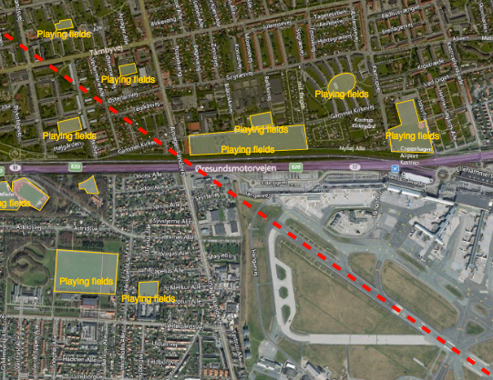
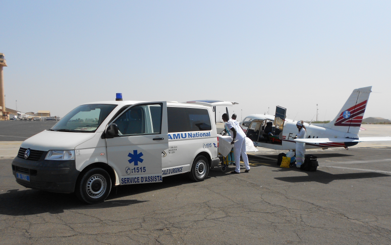
Reducing the risk of bird strikes using satellite images and Ascend’s Normalised Difference Water index software (NDWI)


BROWSE PROJECTS
Based on user needs and industry skills, the evolution of customized solutions and the establishment of innovative services is accomplished through project activities. Focusing on various thematic areas, relevant information on the project activities is provided below.
GISSMoR
Status date: 28 April 2023
We want to utilize mobile robots for performing two distinct services simultaneously: 1) Creating or refining the precision of GNSS-based GIS maps of sidewalks using our mobile robots for data collection via adequate sensors/cameras. 2) Collect data on the quality of the sidewalks using accelerometers already in the robot, coupled with an AI camera for visual confirmation.

CACHE Net Zero
Status date: 24 April 2023
CACHE Net Zero is focused on the development and commercial deployment of a subscription-based service, aimed at Maritime Port Authorities, Port Operators and Shipping Operators. The service informs and contributes to port and shipping operation environmental sustainability and energy efficiency, leveraging access to satellite data sources, while also responding to the linked concerns about air pollution and progression towards net zero emissions in maritime ports and harbours. CACHE Net Zero data intelligence inform Port de-carbonisation and pathway towards Net Zero.

DeGAS
Status date: 24 April 2023
DELPHI IMM is developing a service to estimate GHG removal from afforestation projects using remote sensing. The service is aimed to provide insights on carbon storage in vegetation for all entities along the carbon offsetting value chain and present the results in an appealing user-interface including maps, time-series, and reports.

SatMRV
Status date: 24 April 2023
Soil is critical in combating climate change. It can capture carbon from the atmosphere and store it in the soil while growing food. Carbon farming requires continuous measurement of Soil Organic Carbon (SOC) and rewarding farmers for positive change. Now, how to measure SOC on a regular basis at cost and scale? Because “if we can't Measure it, we can't Manage it”.
THIRSTY
Status date: 20 April 2023
With Project THIRSTY, Hydrosat is deploying two commercial products to enhance food security: 1) we provide accurate yield forecasts that help agribusinesses manage supply chains more efficiently, and 2) we implement a farm management system that helps growers increase crop production while conserving water.

SBWS
Status date: 15 April 2023
In the era of access to huge data resources, advanced analysis and data-to-information processing are essential in the decision-making process. SBWS in the form of friendly web portal, provides advanced analytical tools and a structured data repository, designed to support environmental monitoring using remote sensing data.

Netcarbon Intelligence
Status date: 15 April 2023
NetCarbon revolutionises global carbon sequestration measurement through our Carbon Intelligence Platform, which utilises satellite data to help Cities measure their carbon storage, plan improvements, and manage implementation. Our technology meets the dual challenge of contributing to carbon neutrality while respecting regulatory constraints to fight climate change, together.
IMMAGINA
Status date: 14 April 2023
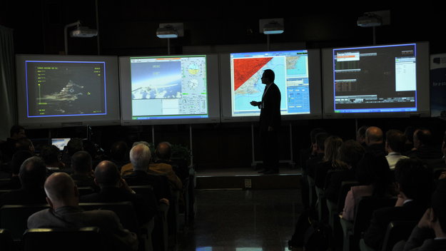
IMMAGINA is a digital platform including software modules, surveillance devices, satellite systems and 5G components that combine detection and monitoring functions with the most modern tools for Control Room and Operation Centres. It offers the most complete range of imaging and image-based analysis services to government and private law enforcement agencies.
Steadycast
Status date: 14 April 2023
Steadycast is an advanced solar forecasting platform for optimizing solar energy integration into power systems and electricity markets. Based on Physics-AI Hybrid modeling and fusion of heterogeneous geospatial data like Earth Observation (EO), it provides worldwide top quality real time and historical forecast data via API. Tailored web visualization tools are also available to better support decision making from planning to operations.
TransDIm
Status date: 11 April 2023
Adaptix are Transforming Diagnostic Imaging by bringing low-cost, low-dose mobile 3D imaging to patients. Today, common conditions such as fractures, cancer and lung disease are initially assessed by 2D X-ray which gives a fundamentally limited view of our 3D bodies. The products being developed in this project will deliver fast, accurate 3D imaging to these patients.
DHDE
Status date: 05 April 2023
This Business Applications Feasibility Study aims at assessing the technical feasibility and economic viability of space-based services and solutions in the area of digital health, for instance storing and managing health data on people’s existing computers or mobile phones. supporting health infrastructure in developing economies, with focus in Africa and India.
EM
Status date: 04 April 2023
This project followed a successful Feasibility Study in improving the GEOSATIS EM system/service, based on a next-generation GNSS bracelet, satellite communication/imagery; to enhance the current electronic monitoring system to a level where Geosatis has an edge over its competitors in terms of; communication, proximity, detail, signal broadcasting, bandwidth, and device use in a larger geographical area with limited. communication signals.
.
RANGLO
Status date: 04 April 2023
Data integration and predictive analytics service for rail freight in the UK. The Ovinto unique, complementary software platform will help and feed the existing software infrastructure for different users and customers, connecting any relevant internal & external data source to make software modules/silos extremely flexible through collaboration, data exchange and integration.
https://business.esa.int/projects and search results.
SP4GO
Status date: 14 February 2020
SP4GO feasibility study addresses the needs of Distribution System Operators (DSO) and Transmission System Operators (TSO) using innovative solutions.
Demand/Response and e-Mobility needs will be addressed in the context of Smart-grid area, while for the infrastructure operation and maintenance (O&M) the services considered are vegetation monitoring, electric consumption estimation, impact of weather events such as lightning on energy infrastructure, and satellite backup platforms for data exchange and communication.