
Objectives of the service

The objective of the solution developed is to help companies in the agricultural sector to combat weather and climate hazards. A good knowledge of these data helps them organize themselves better and reduce the loss of time, limit the consumption of pesticides and natural resources, improve yields and not unnecessarily expose human lives.
The tool developed therefore present reliable and quickly identifiable data, adapted to users since co-created. This interactive solution can be viewed and used directly from the production site.
Users and their needs
Now, only few countries offer high-resolution weather information to their population, through their National Meteorological and Hydrological Service (NMHS). In 2/3 of the countries, NMHSs do not have capacities to run high-resolution weather models on sophisticated computing facilities, fed by dense ground weather stations networks as well as earth observation satellite data, according to a study by the World Meteorological Organization. Like in Internet, there is a Weather Divide.
The users targeted by this project are agricultural companies and cooperatives. All over the world, agriculture is weather-sensitive and crops are therefore strongly impacted by climatic conditions. The new service is therefore proposed in priority to the agriculture sector for:
- International Agriculture groups,
- Local large farm producers.
For both customer segments, the climate information should be reliable, accessible, and precise. They need a very practical user-tailored climate service that gives access to accurate weather indicators easily available and easily deployable.
The cooperatives want to have a better understanding and management of their field activities and improve significantly their yield by using high resolution weather service.
Global companies, on the other hand want to improve the sales of products and the customers satisfaction.
Service/ system concept
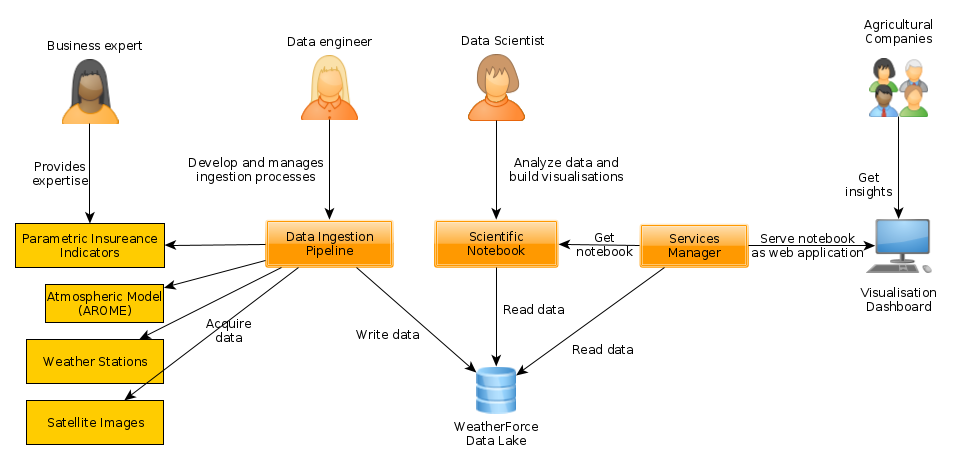
The solution, offered via a dashboard, allows different users to quickly access weather information to inform their decisions. The dashboard proposes the visualization of different indicators (disease risk, efficient rainfall...) in the form of maps or graphs but also a whole vision on historical data to analyze past events.
The system is based on the WeatherForce collaborative platform, where data from IOT stations, earth observation satellites and various meteorological models, including a high-resolution model, AROME, is combined.
The WiForCrop service is an all-in-one product, for crop managers, to access weather and agrometeorological information and better manage fields.
Space Added Value
The project used various assets, from Meteosat for rain precipitation (nowcasting) to improve weather prediction a posteriori (machine learning and forecast verification), since targeted areas may be poorly covered by ground weather stations data. Many satellite images are unused because they contain clouds. This useless data for satellite operators becomes useful information for our forecasting activities.
Current Status
The WIS project started in March 2020. Because of the health situation worldwide during this year, the on-site missions had been postponed and the workshops had to be held remotely. Despite this change, the workshops could be carried out. ACP, a Peruvian cooperative which produces blueberries, avocados, grapes, and asparagus, was the pilot user for the WIS project and helped us to develop a suitable solution to address the agriculture sector by co-creating a specific tool. The workshops allowed us to determine the user needs and requirements and start thinking of the solution.
In April 2021, the Factory Acceptance Test was passed, even if the agromet stations were still under development by the Peruvian partner, IOTLAB.
The On-Site Acceptance Test (SAT) was successfully passed during the first mission in August 2021 and led the way to further improvements: first weather station installed in the fields, training of users on the solution and delivering the first version of it. This mission has also been the opportunity to meet agro-companies, in person, to present and validate the WiForCrop solution.
The second mission, in November 2021, saw the installation of the last weather stations in the crops of the pilot user. After two months of testing the solution, feedbacks about data and visualisation have been given, and modifications, according to them, implemented. Once again, this Peruvian mission was an opportunity to meet leads and prospects in order to present them the WiForCrop solution.
The WIS project has been closed in December 2021, but the pilot users are still using the solution, including the 4 new stations, and then as customers, as the negotiations has started.
Prime Contractor(s)
