Objectives of the service
The overall objective of the project is to prove the viability and sustainability of an integrated software package and associated services aimed at delivering an independent source of data to support an improved and more cost effective forest certification. This will be based on the integration of Earth Observation (EO) and navigation technologies (GNSS) for in-situ sampling within an open source Geographic Information System (GIS) environment. The viability of TransparentForests will be assessed from technical, operational and financial perspectives.
Users and their needs
Umbrella user is the Forest Stewardship Council (FSC). Other users are FSC’s accreditation body Accreditation Standards International, the Certification Bodies and the Certification Bodies’ clients, the Forestry Organisations.
FSC stakeholders such as ENGOs (e.g. WWF and Greenpeace) and forest communities will also be granted access to the service platform.
Service/ system concept
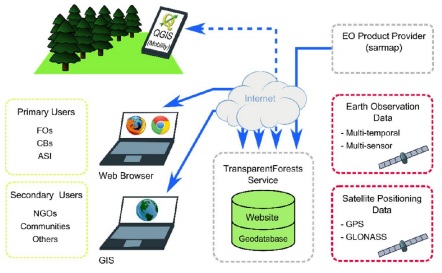
The diagram above presents a high-level representation of the TF system / service architecture. The TF Online Service lies at the centre of the architecture, acts as a central data store and interacts with three main interfaces with the users as well as the EO Product Provider. Two space assets are used by TF: Earth Observation and Satellite Positioning.
TF provides three interfaces for users: TF Web, TF Desktop and TF Mobile. TF Web is a WebGIS application, accessed through the user’s web browser and allowing (amongst other things) FOs to upload management data, CBs to plan audits and Others to view data and make comments.
Although TF Web provides functionality for users to upload spatial (vector) datasets, some will find this more efficient using their GIS of choice. TF Desktop therefore provides an interface allowing users to provide and retrieve spatial datasets directly from their GIS.
EO products are used heavily by CBs when planning / performing audits. EO Products are requested by the user and generated on-demand by the EO Product Provider. Once available, the generated EO Products will be stored on the TF server.
TF Mobile provides an interface for users (particularly CBs) located in the field. TF Mobile allows users to visualise their position in the context of TF EO & vector datasets, comments, notes and other related data. It also provides a simple interface for capturing and geo-referencing field information (e.g. photos or comments).
The connection between TF Mobile and the central TF Service is shown as a broken line as TF Mobile will not require an internet connection while operating in the field. It will instead cache any required data before leaving for the field (when network connectivity is available) and synchronise any edits / new field data again on returning.
Space Added Value
Earth Observation
To provide an independent source of temporally and spatially accurate data (e.g. land use and land use changes across the audit period) to support better certification based on both Medium and High Resolution Remote Sensing data sourced from both optical and critically, radar as many forests are located in areas with a high incidence of cloud cover.
Products already validated through earlier EOMD projects on certified forest management units include:
- Mapping and monitoring forest areas within the landscape (size, boundaries, type, change)
- Detection of illegal encroachment
- Identification and monitoring of High Conservation Value (HCV) areas
- Monitoring and protection of buffer zones
- Mapping and monitoring annual clear-cut areas and their location (identification of retention trees and mapping stand mosaic)
- Mapping and monitoring forest diversity (e.g. species, structure)
- Appearance and changes in settlements within the forest area
EO will also be a valuable source of data for the auditor to monitor legal and illegal activities outside the boundary of the forestry organisations being certified.
Satellite Navigation
In-situ geo-referenced data is needed for several reasons:
- relevant landscape information (e.g. protected areas and buffer areas) has to be integrated into EO derived data so as to link current status of the forests and the protected biomes;
- management information (e.g. forestry management units, boundaries, roads) has to be spatially and temporally accurate when linked to EO derived data.
- georeferenced physical field parameters are required in order to calibrate spatial imagery.
Therefore, operational maps, audit tracks, operational polygons, on-site photos and biophysical parameters measured in the field need to be geo-referenced and made available to selected stakeholders in a convenient and standardized manner, driving the requirement for automated, accurate and timely GNSS data within a single processing chain.
It is also planned that new features will be added, such as integration of field audit information. It will be investigated whether current GNSS inaccuracy created by shading and foliage cover could be resolved via the inclusion of current and future GNSS systems including Galileo, GLONASS and COMPASS.
Satellite Communication
SatCom may eventually be considered for a limited subset of stakeholders (e.g. NGOs or forest communities) where internet connection is not available or not sufficient to provide operational access to the TransparentForests platform.
Current Status
The Feasibility Study kick off date was 22 December 2012. The definition of the user segments and user needs, the specification for the TransparentForests system and service architecture was completed in the first half of 2013 and followed by the development of a proof-of-concept which was used in a viability analysis across all stakeholder groups, based on webcasts and interviews.
The project has enabled the TransparentForests team to undertake a detailed assessment of user needs and requirements, which formed the basis of the TransparentForests service and system design. This will enable FSC to mitigate costs of certification, and reduce the potential frequency and severity of errors in the certification process. The potential for certifiers to access independent EO derived products defining land cover and land cover changes, combined with the potential for certifiers to record field inspections and tracks, will fundamentally improve the reliability, transparency and safety of certificates issued. Once operationalised, TransparentForests should result in an expansion of the FSC certified area, especially in high risk domains such as large tropical and boreal forests.
The Feasibility Study was completed in January 2014 and has been followed by a Demonstration Project.
Prime Contractor(s)
Subcontractor(s)