Objectives of the service
Use a bold image to start your webpage. It can be a photo or an infographic like this. Remember that you project webpage can be a powerful marketing tool.
Climatic change is heavily impacting water ratios across the globe. Furthermore, due to ancient water distribution networks and aqueducts, to this day still buried beneath great portions of the urban and sub-urban environments and requiring hefty maintenance actions, water losses are neatly increasing in number, year after year, reaching an average percentage of up to 37%, when compared to the water immitted in the entire Italian water network system.
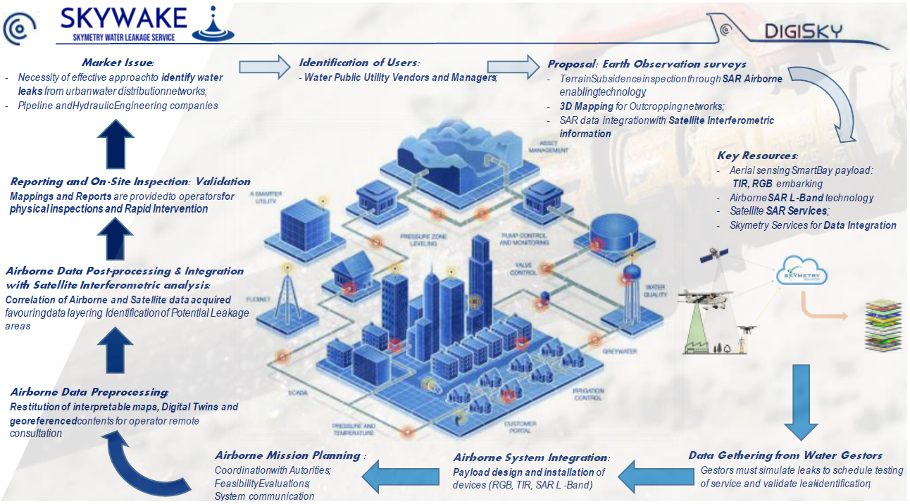
For the present reason, Public Utilities and Vendors urge with the need of disposing of an effective measure which allows operators to limit on site surveys, containing the costs and risks involved, and propose a more punctual intervention. By interviewing potential stake-holders as SMAT, for instance, the use of Earth Observation data can become an effective way of monitoring their networks in time especially if capable of highlight those urban sites undergoing leak phenomena. Combining satellite Interferometric analysis and high-resolution airborne surveys (Thermographic, Optical, Synthetic Aperture Radar) the goal of the proposed study is to provide end-users with an end-to-end service able to inspect a desired portion of territory and return georeferenced thematic maps and reports highlighting the location of leaks the framework.
Users and their needs
The present PoC has been conceived to address one of the most critical markets affecting both the national and international panorama: water network distribution.
Through dedicated interviews, DigiSky has gathered various needs expressed by both managers, operators and distributors of local water services. More precisely, SMAT, IREN, ENEL and Consorzio Nettuno, fundamental players in the distribution and management of hydric resources across the Piedmont Region and the Italian Peninsula, have all expressed the need of disposing of a service capable of responding to the following quests:
-
Identify effective working strategy to minimize time of intervention on damaged networks;
-
Identify water network’s location in case they are not geolocated (eg. Semi-urban/Rural environments);
-
Ensure effective water distribution by reducing losses (costs for inspections, monitoring);
-
Optimize dams water collection by monitoring dams;
-
Permit repetitive surveys in time of the water infrastructures;
As the major challenges result being the integration of Earth Observed data within a unique environment, a Digital Twin model which may consent the operator to remotely inspected the networks of competence across cities, SkyWake proposes an approach capable of integrating both Satellite and Airborne Data guiding the management companies towards an optimization of the actual on-going procedures optimizing costs of intervention and minimizing the risks for their operators.
Service/ system concept
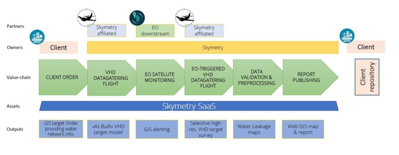
SkyWake has been intended as an End-to-End service. It is meant to address the needs of water distribution gestors who manifest the need of remotely inspect their infrastructures limiting the intervention of their operators and guiding decision-making processes in an effective and updated manner.
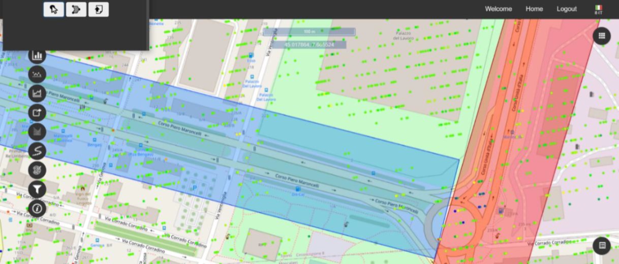
The present service has been designed to acquire all information from the client concerning the distribution of his/her networks, manholes and basins (for hydroelectric companies) understanding their distribution in the urban and semi-urban environments. CAD and GIS files shared, may help the DigiSky Team to plan surveys optimizing flight trajectories and acquisition especially if the distribution of targets results heterogenous. As the order is disposed, the flight management team will coordinate airborne surveying activities with the aeronautic authorities whilst a dedicated engineering team will board on General Aviation Aircraft the most suitable sensor suite to obtain a preliminary model of the desired target areas. Satellite Interferometry will be then implied for the scatter metric analysis over a wider territory allowing to have insights on both urban and more remote areas. Alerts, generated by ongoing exceeding displacements, will be integrated within the Skymetry platform to command subsequent aerial proximity surveys obtaining information concerning the network status and an updated Digital Twin Model.
As survey data are acquired and pre-processed, thematic maps may be generated. The implementation of Artificial Intelligence may be then used to combine, in a post-processing phase geospatial layers allowing to classify and generate reports to be given to the technical operators which will then operate on field.
Space Added Value
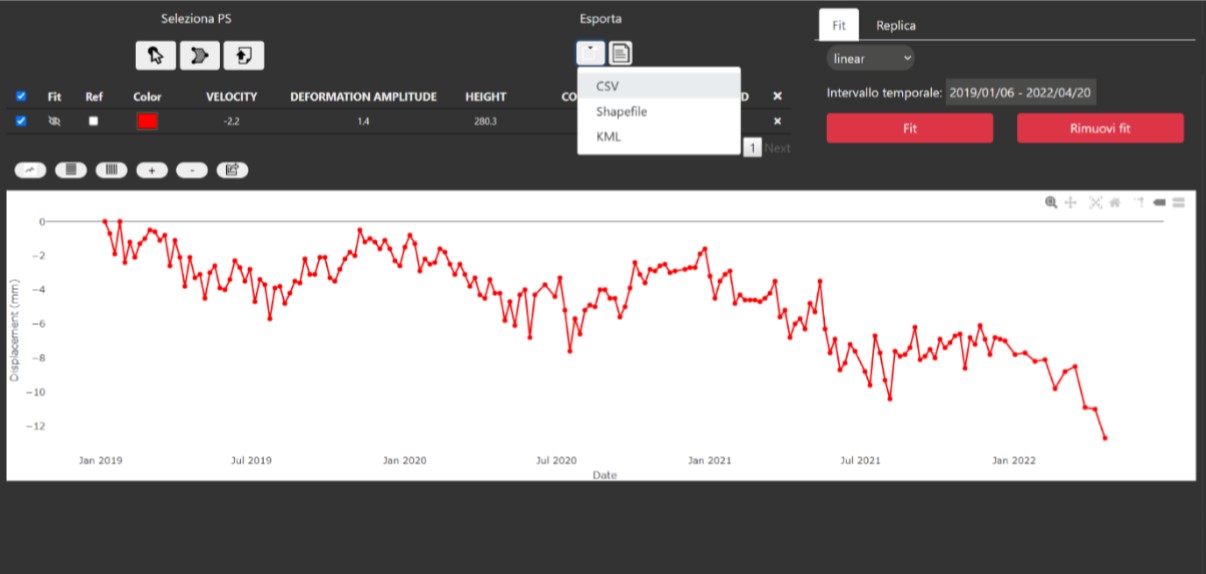
As high-resolution aerial surveys are carried out, Satellite Interferometry will be used to obtain time series of events verifying the occurrence of subsidence phenomena which may be correlated to a potential leak outsourcing. As Permanent Scatter movements overcome pre-established thresholds, an automatic triggering will be sent to the Mission Planning system commanding additional high-resolution inspection.
In this sense, satellite downstream data, proceeding by either Sentinel-2 or Cosmo SkyMed sources, will be deployed as an enabling technology to deploy aerial mission and thus indicate in a punctual manner which areas require primary inspections. The present approach may hand to the operators multiple benefits as:
-
Remotely consulting the information of their networks;
-
Perform punctual operations of inspection and maintenance;
-
Generate a historical archive of events and monitor maintenance operations in a time series basis;
-
Diminish losses by elaborating more effective and rapid contingency actions;
Current Status
By firstly interviewing End-Users, the location of on-going and simulated leaks has been used to schedule airborne missions. As flights have been scheduled a preliminary acquisition has been performed using thermographic imaging sensors.
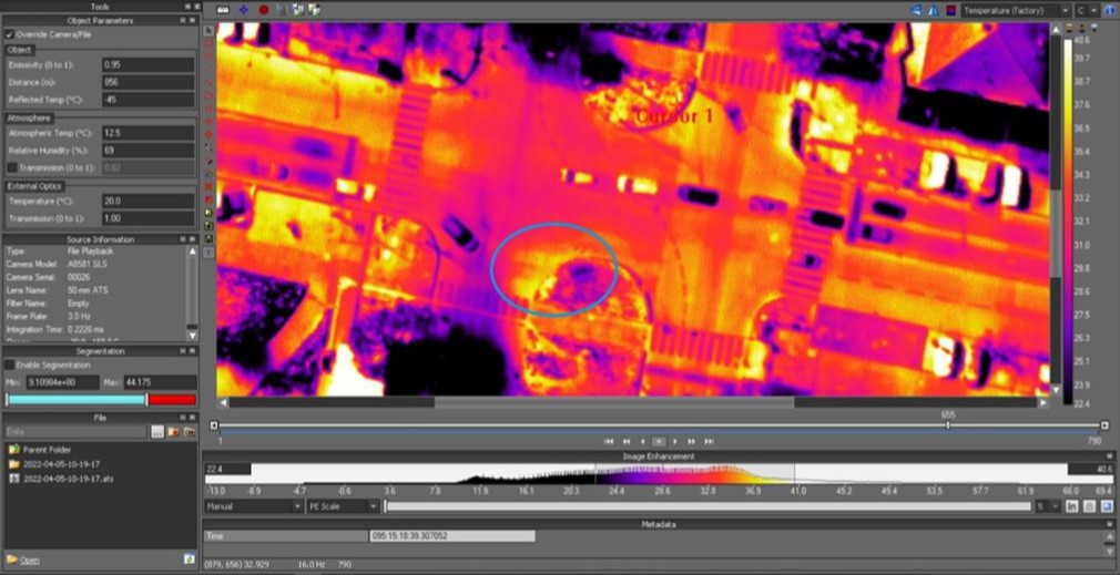
Outcomes have reported some uncertainty due to variability in both the atmospheric conditions and environment observed. For the present reasons, additional surveys have been performed adopting Synthetic Aperture Radars operating with an L-Band of 200 equivalent MHz. As L-Band SAR’s are capable of penetrating the first 50 cm of surface monitored, coherently with the typology of terrain monitored, the present technology has been chosen as the technological measure most suitable for the current application.
After a Pre-Processing stage, in which the coded files have been transformed into polarized SWAT’s, georeferencing was possible, allowing to obtain a preliminary assessment of the dielectric coverage of the target area.
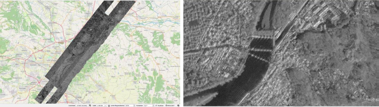
Contemporarily, Satellite Interferometric Analysis was carried out by e-GEOS specialists, who managed to unroll a two-year time series of events, over a portion of the urban landscape of Turin and extending towards the Western of the Susa Valley. Interferometric analysis has been carried out analysing the subsidence phenomena occurring in the Region Of Interest highlighting those Permanent Scatters overcoming critical thresholds. These points will then be used as the triggering alert which will command additional airborne surveys to be performed.
In the optics of further developing the service the goal will be to analytically combine the Airborne SAR L-Band polarized swats to obtain an equivalent map, which, once layered among thermographic and RGB results, will undergo Artificial Intelligence algorithms capable of classifying leaks, and their related degree of severity and annotating where physical inspections should be carried out.
Prime Contractor(s)