
Objectives of the service
CGG are defining and creating an innovative SeaScope service to establish the source of pollution slicks in proximity to assets in response to repeat enquiries from oil and gas operators.
Being developed by CGG’s Satellite Mapping business unit, with support from the European Space Agency, SeaScope provides high-cadence, cost effective, satellite-derived information over offshore assets to establish individual asset baselines and rapidly identify anomalous events. The emphasis of the SeaScope service is on the regular delivery of high-quality, reliable, unbiased information to enhance situational awareness and mitigate environmental risk.
SeaScope aims to provide tailored, asset driven information allowing users to:
Improve asset management
-
Enhanced situational awareness
-
Evidence of good practise
-
Early detection (preparedness as a precursor to emergency response)
-
Long term monitoring
Mitigate against false culpability
-
Identify local pollution events
-
Construct an evidence base (perpetually growing)
Users and their needs
The core users of SeaScope are offshore oil and gas operators. The initial phases of SeaScope identified a number of user requirements in the oil and gas community for the identification of offshore pollution in close proximity to oil and gas infrastructure. Key user requirements are consolidated into five broad topics: location of interest, timeliness, quality of deliverables, frequency of deliverables, and confidence of interpretation. User requirements can vary greatly per user and are dependent on the application of the information within individual oil and gas companies, i.e. environment, crisis management and operations. It is therefore vital that SeaScope provides a flexible approach, which is tailored to individual asset need.
SeaScope is a global service; however, the focus of this demonstration is the North Sea.
Service/ system concept
SeaScope provides users with reliable intelligence on the distribution, extent and source of pollution slicks around their individual offshore assets in a cost-effective manner. Delivery of information from SeaScope occurs via automated web-based delivery mechanism. Users can visualise and interrogate critical slick information layers, which are complemented by summary reports.
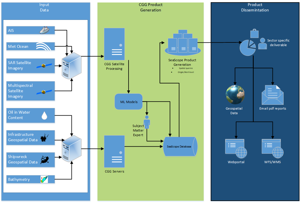
The diagram below outlines the high-level system architecture of the main system.
Space Added Value
SeaScope integrates two space assets: Earth Observation satellites (principally SAR but also Sentinel-2) and satellite AIS data. Satellite imagery is used to observe offshore slicks and CGG brings world-leading slick interpretation expertise to the SeaScope workflow, enabling the reliable generation of high-quality, slick mapping and monitoring intelligence. Combining this with satellite AIS data, when utilised, enables the identification of potential pollution sources from local vessel activity. The increasing availability of regularly acquired, cost-effective satellite data significantly enhances the ability of offshore operators to understand the occurrence and evolving behaviour of pollution in close proximity to their infrastructure and, in many cases, provide the ability to confirm the absence of pollution so that operations may continue unhindered.
Current Status
SeaScope follows on from the successful OAPM demonstration project that completed in Jan 2021.The additional changes to the service include two key updated requirements from users: individual asset alerting and improvements to the quantification for slick volumes derived from satellite remote sensing. To accomplish this additional development is required and a yearlong CCN was approved by ESA for continued development to the SeaScope service, this began in November 2023 and the FAT will be held in January 2024.