Objectives of the service
The European green deal aims for a 20% fertiliser reduction by 2030, banning commonly used chemical compounds in the next 3 years. At the same time, fertiliser prices have increased by 300% during the last years. Therefore, crop production is facing major challenges and farmers are claiming for new solutions.
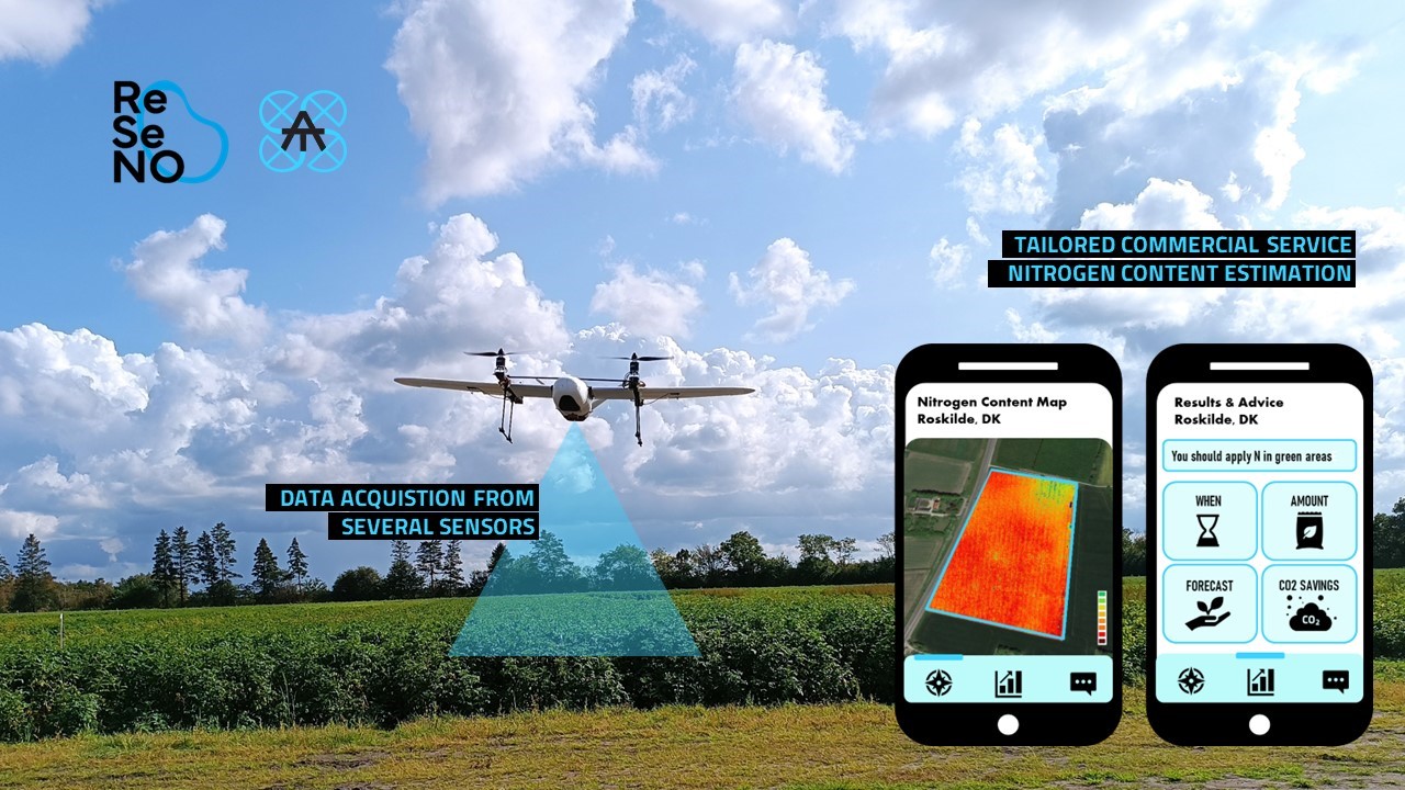
The ReSeNO service provides an innovative and multi-layered solution to efficiently estimate nitrogen content in potatoes by combining data gathered from the Aerial Tools Unmanned Aircraft System (UAS) and Earth Observation Sentinel 2. Estimation of nitrogen content is computed from open source machine learning methods and models.
Farmers can access simplified maps and fertiliser recommendations through a software interface, empowering them with accessible tools to make the right decisions along the growth season, promoting sustainable practices and adapting their operation workflow.
Users and their needs
The ReSeNo service targets AgriTech companies and large farmer cooperatives in Europe as they manage or own large areas of lands and have the economic resources. More specifically, Aerial Tools is targeting large industrial plantations of seed potatoes in Denmark. These large plantations frequently use traditional agricultural techniques and typically operate on a great scale. Large industrial plantations can enhance their operations using superior equipment, technology, and resources compared to individual farms. On the other hand, eco-farmers often employ organic or sustainable agricultural methods. These farmers prioritize a high value on biodiversity, environmental protection, and the cultivation of superior, chemical-free crops. Thus, they are also an attractive target group as they look for advanced solutions to improve their profitability.
Service/ system concept
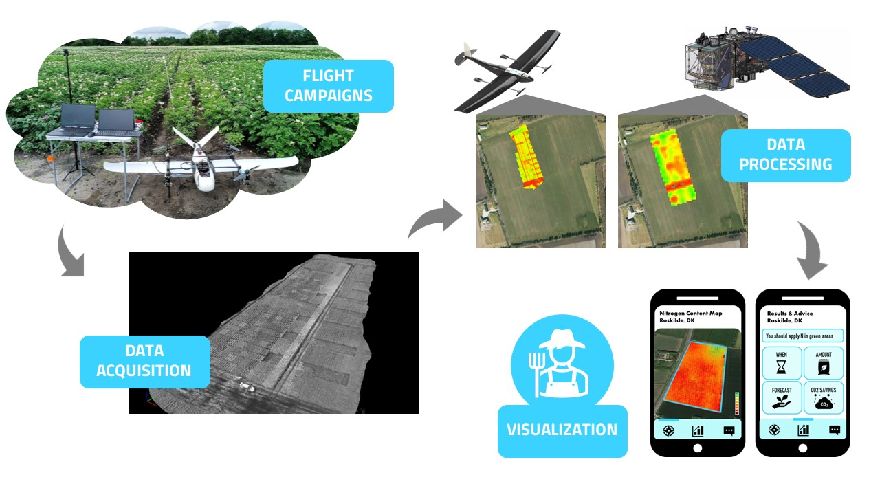
The ReSeNO service handles all the processes related from flight campaign preparation to data visualization and advice. Flight preparation and campaigns are conducted by the Aerial Tools team using their innovative drone with a multisensory setup. Data is acquired from a multispectral and a thermal camera placed on the drone and combined with Sentinel 2 data. After that, the data is processed and analysed using vegetation indices, machine learning methods and models to estimate nitrogen content. 3D maps are also obtained for better overview of the field and combination with satellite data. Finally, the information for an optimal nitrogen fertilization is shown in an accessible and easy to use software interface that can be compatible with customers own systems.
Space Added Value
To reach a successful service, the drone requires high accuracy positioning and timing during data acquisition using RTK GNSS in a real environment. For a more precise nitrogen estimation and better overview of the crops, drone data is combined with Sentinel 2 data. This provides already a competitive advantage as most of the competitors only use satellite data or drone data to estimate nitrogen content. Through 5G connectivity, the drone is expected to connect with ground monitoring systems to provide real time data for farmers during the drone operation. This will be a game changer to easy visualize the results of this service. In addition, 5G provides a redundant communication system as a backup for the telemetry, improving unmanned traffic management navigation and operational control of the drone.
Current Status
The system was tested in field trials of potato crops with different levels of nitrogen content in Jutland. The Aerial Tools team performed two flight campaigns collecting multispectral and thermal data during the summer. Currently, drone and satellite data are being processed to estimate nitrogen content using different methods.
Prime Contractor(s)