
Objectives of the service
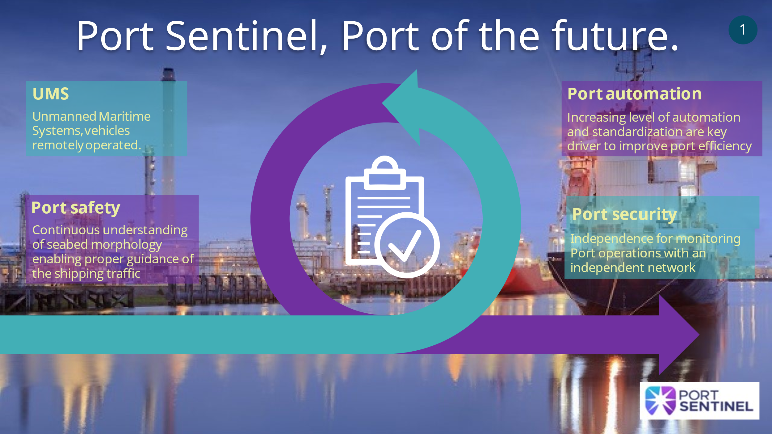
The project aims at assessing a suitable pathway to market a tool for Seabed Port Monitoring, integrating satellite navigation data and common measurement devices. Improving port infrastructure monitoring is the key advantage of the proposed technology and the core objective of the prospected work. Moreover, the aim is to guarantee the safe transit of the ships. Autonomous or semi-autonomous instrumented boats or punts with capability of detecting the current morphology of the seabed can be used to provide status of the harbour floor and assess the required maintenance work and the effects of previous interventions. If such measures are performed by simple and compact elements, that information can be accessible continuously, with outstanding advantages for the harbour management. In order for this information to be exploited at their maximum potentiality, it is necessary to construct a valid interface with the operators that can access and understand them in short times. Data availability, accessibility, and human data interface, are the key to the herein proposed technology, and represents the ultimate target of the envisaged service.
Users and their needs
Communities targeted are the Harbour areas/ Port authorities.
Among the several aspects associated to the port infrastructure affordability and operability, guaranteeing a safe passage for the shipping is a key need of the ports. Integrating proposed intelligent technologies and suitable data management (including data accessibility and data sharing), in a single service aimed at supporting Port Authority operations may have paramount importance for properly facing those new challenges. The project purpose is to provide an end-user service aimed at increasing navigation safety in harbour areas with shallows water and reduce the risk of stranding large tonnage vessels through bathymetric surveys.
These aims are reached by:
-
Tracing and tracking of UMS, performing measurement campaigns.
-
Measurement data collection and archiving.
-
Automatic updated of bathymetric maps.
-
Creation of predictive models of seabed variations caused by large ships traffic and spring tides.
-
The final product can be used by harbours around the world as per the minimal infrastructures and software requirements.
Service/ system concept
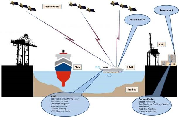
The measurement campaigns shall consider IHO (International Hydrographic Organization) requirements for special areas and the IIM (Istituto Idrografico della Marina) requirements. The proposed service system is made of an instrumented UMS and an information centre. Such a service centre shall make available data and applications to end users, according to the cloud-based “as a service” paradigm. The basic scenario envisages that the UMS performs a data gathering campaign in the port area collecting data through a set of sensors. During the data gathering campaign the UMS transmits its PVT (Position, Velocity and Time) data, acquired by the on board AIS (Automatic Identification System), to the service centre that will plot the current position and the traffic situation in the port area on a map. The port will be provided with an AIS receiver and an AIS box to collect data from ships and transmit them to the service centre. A local weather station close to the port entrance and connected to the AIS box, shall collect real-time weather condition contributing to a complete picture of the port situation. End-users shall access that information by accessing the cloud through the service centre. It will store data gathered by the UMS and will process them to update seabed maps and feed a predictive system to evaluate seabed evolution soon. Such a service to ports will support their daily operations and optimise dredging operation of seabed.
Space Added Value
GNSS is envisioned because of its higher accuracy, the possibility to benefit from the authenticated navigation message (OS-NMA), which is of utmost importance for remotely piloted and autonomous systems, and finally because EGNSS use permits achieving another forward step in the independency of the strategic European resources with respect to foreign-controlled instruments like GPS. Precise GNSS-based positioning information is essential for the bathymetry itself and for the manoeuvring of the UMS, especially if running (semi-)autonomously. Integrity and authenticity of the navigation signal is desirable for the bathymetry and essential for an autonomous UMS.
PORT SENTINEL ambition can be referred to the integration of European Global Navigation Satellite System (EGNSS) precise positioning, the direct compensation for errors due to fluctuations during measurements, the provision of systems enabling the seabed monitoring to create a detailed cartography minimizing operation time and costs and the development of a seabed evolution model. The use of EGNSS in precise positioning application inside a maritime port and harbour areas assures accurate and reliable position detection by using differential corrections and integrity services.
Current Status
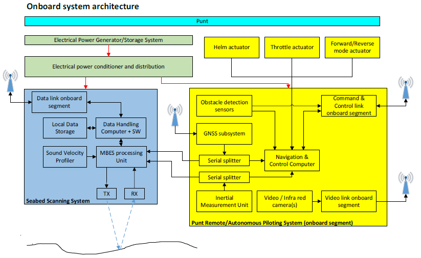
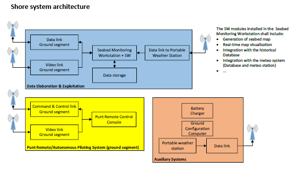
Established the consortium where all stakeholders (Reload, SIRM Italia, CIRA, ALPHA, ADSP, UNIROMA and UNISALERNO] who will be involved directly in the development of the system that could be divided in two main architeture as shown in the following images:
Targeted market segments have been identified as Port Authorities and Private Port Operators, Bathymetry Service Providers, Dredging Companies. The addressed customer segments are for the short to mid-term, bathymetry service providers using the solution to provide service to port operators and for the mid to long-term, port operators directly using the solution.
Port Sentinel has been envisaged to be a complete solution of HW (USV+sensors) and SW (inCloud platform) with a key customer in mind, who at the same time are the user of the system: that is Port Authorities, which also involves private independent ports operators.
Prime Contractor(s)