
Objectives of the service
The overall principle of this service is to identify and develop relevant indicators, produced from spatial data (satellite images, GIS data...), to support organic farming professionals in their task of planning and organic certification.
MEO-Certif provides an added value service to improve the reliability and the compliance of the certification and control operations. The service is designed to be a real decision-making tool, thanks to the complementarity of the indicators, the resulting analysis thus offers a new and useful vision for the main organic farming players.
Users and their needs
The users targeted by the service are European certification bodies in organic farming and French agricultural cooperatives.
The certification bodies are behind schedule with regard to the digitization of some of their tasks. However, in some countries the problem is not with the certification bodies themselves but with the procedures put in place by governments. Digitization would allow certification bodies to save time, improve internal organization, improve conditions for employees, and in particular perform audits more reliable and within shorter deadlines.
The agricultural cooperatives are created to structure the sector and pool the farmers’ means and resources. The main need of cooperative managers is to be able to anticipate the future in order to calibrate planning actions. A good knowledge of the territory, agro-climatic potentialities is therefore necessary to make prospective scenarios.
The targeted users also have common needs, such as:
-
Increase the reliability,
-
Modernize and digitize activities,
-
Have a customized solution.
The challenge for the service is to propose, from a common base, a customizable service to meet the differentiated needs of the two types of users identified
Service/ system concept
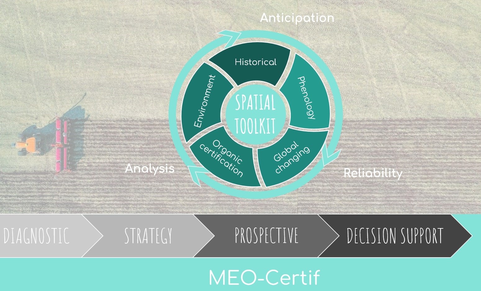
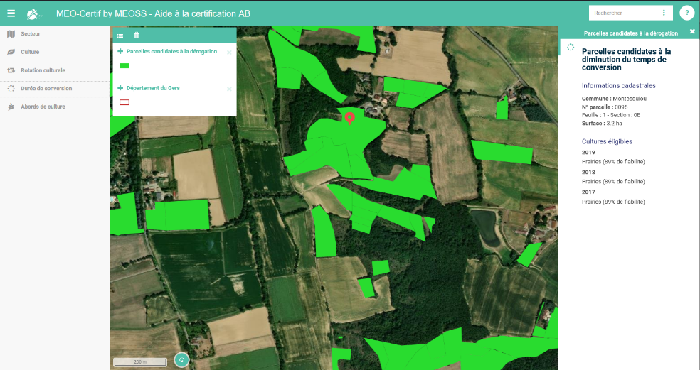
MEO-Certif is a web mapping consultation tool. Intended for a non-expert audience in geographic information systems, this viewer is designed to be easy to use and intuitive. The goal is to give maximum autonomy to auditors. Access to indicators is made easier through previously structured and understandable information.
In addition to the basic functions (zooming, moving, modifying the base map), the tool allows you to view localized information and compare several indicators. Beyond the simple visualization, the user can interact with the data by modifying the cartographic representation (opacity), by filtering on an attribute, enriching the cartographic information by clicking on an entity. A help sheet is also available to help users get started and interpret the information.
The toolkit provides spatial information about:
-
Crops analysis (rotation history, evolution, plots eligible for the reduction in conversion time);
-
Hedge detection (risk of pollution, risk of erosion);
-
Vegetation cover profile (outdoor poultry courses, phenology);
-
Moisture profile;
-
Surface temperature.
Space Added Value
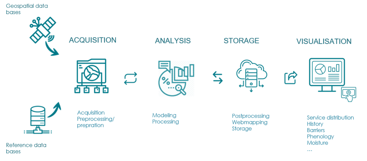
The added value of this solution comes obviously from the contribution of data from earth observation.
Satellite data offers incomparable temporal tracking, relevance and high precision. Coupled with local data, the analysis models developed from satellite data are enriched and their reliability is improved.
The added value of MEO-Certif resides in the numerous advantages mentioned above, which also save time and modernize the activities of certification bodies and agricultural cooperatives.MEOSS ontribute its expertise in spatial data processing and analysis, as well as in Machine Learning applied to space imagery data. Access to Copernicus data* is a decisive element for the implementation of the proposed system. The high repetitiveness of the images allows to analyze very large areas in a very regular way, making their use particularly adapted to the context of organic certification.
*Copernicus data used:
-
optical images: Sentinel-2
-
Radar data: Sentinel-1
-
Weather information: ERA5, C3
-
Derived products: landcover maps (OSO), soil moiture maps
Current Status
The key results are a panel of cartographic decision support indicators for Certification bodies and agricultural cooperatives. The indicators are available online with secure access by means of a login and password. They give access to an easy-to-use and entertaining cartographic interface. Users can choose the indicators to be displayed, their display order, display additional information and move around the experimental area.

The technical feasability step allowed to iterate with potential customers and partners on indicators, their display and validation. Overall, the majority of the panel of indicators identified are technically feasible using free and open-source data (rotation history, Barriers/risk of pollution, crop areas’ evolution, phenological cycle, weather conditions and soil moisture), with the exception of two indicators (AB eligible plots and Outdoor poultry runs).
The Proof of Concept revealed a gap between the operational teams who expressed the need for a decision support tool to improve and optimize their daily work and the decision-making strata for whom the act of purchasing is motivated/constrained by the legal value required in the certification procedure.
The back and forth with the second segment, Agriculture cooperatives, has allowed to better appreciate the real expectations behind the expression of the need initially formulated. Near-real-time management and simulation of future scenarios are the major challenges for this segment. The indicators developed in the PoC enable to test and to validate the technical feasibility on historical data and to identify the inherent limitations. In particular, they do not offer enough guarantee of reliability on the current year.