
Objectives of the service
Today, in the Flanders region, there is often a lack of coordination between maintenance work on roads and the utility assets beneath them. This results in roads being dug up multiple times for different reasons. Aligning asset maintenance, which falls under the responsibility of utility companies, with road maintenance, which is the responsibility of municipalities or government agencies, presents a challenge. Currently, the lack of up-to-date road condition data limits the ability to define long-term maintenance plans. This challenge is not limited to Flanders but is prevalent across Europe.
It is crucial to incorporate road condition degradation into asset management processes of utility companies and organisations responsible for road maintenance, such as municipalities. This integration would enable better budget and investment planning, facilitate the exploitation of synergies and promote collaborative growth in terms of smart infrastructure planning in the public domain.
The study aims to understand the feasibility of using SatEO imagery, more precisely Synthetic Aperture Radar (SAR) images, to assess the roughness, as a proxy of quality, of roads within a wide area, of the order of hundreds of km2.
Users and their needs
Targeted users can be broadly classified into two categories:
-
Road authorities: public institutions responsible for the maintenance of public roads.
-
Utility companies: companies owning assets under public roads.
Road authorities face a number of challenges related to the maintenance of public roads. They can be summarised as follows:
-
Need for objective prioritisation of road works:
-
Visual inspections are highly work intensive and can capture a subjective rather than objective evaluation;
-
There is no global, actualized overview of road health;
-
There is no standardized method to prioritize damage types and roads;
-
Information can be incomplete.
-
-
Need for a long-term view on financial resources for road infrastructure:
-
Incomplete view on necessary budgets for years to come;
-
Incomplete view on the optimal allocation of financial resources.
-
-
Need for synergies with their infrastructure works in the public domain:
-
Minimize inconvenience for civilians;
-
Optimize financial resources by sharing costs between infrastructure owners.
-
Utility companies can benefit from this solution by taking advantage of synergies and thereby sharing the costs of, amongst others, excavating public roads to repair or replace assets beneath it, such as sewage pipes.
Service/ system concept
Using the road quality assessment from SAR images, road authorities will have a first insight into the quality of their road network. While it is impossible to detect damage instances on this resolution, road segments can be categorized (e.g. ranging from good to bad quality). This allows the road authorities to perform a more detailed analysis on specific roads, without first having to inspect the entire network, saving time and costs. Furthermore, this analysis could be used to benchmark different regions, so that policy makers can make (more) objectivized investment decisions.
Space Added Value
The main benefit of using space technology to asses road quality is scale. Manual road inspections are time-intensive, costly and sometimes dangerous. Using SAR (Synthetic Aperture Radar) images can provide road authorities with a first insight into road quality, lowering the need for manual inspection.
A ready-to-use SAR image from a TerraSAR-X/TanDEM-X StripMap product with footprint 30 x 50 km2 was obtained from a commercial supplier (AIRBUS) for the feasibility study. The footprint covers the area between two major cities in Belgium, Brussels and Antwerp, including the city of Antwerp.
The image was enhanced by AIRBUS, offering the highest level of geometric correction available for TerraSAR-X Basic Image Products by correcting for varying terrain height using an external digital elevation model.
In addition to the SAR images, AIRBUS supplied a Geocoded Incidence angle Mask (GIM), providing information on the local angle of incidence for each irradiated pixel, allowing us to perform standard radiometric calibration to σ0 (Sigma Naught) or γ0 (Gamma Naught) values.
Current Status
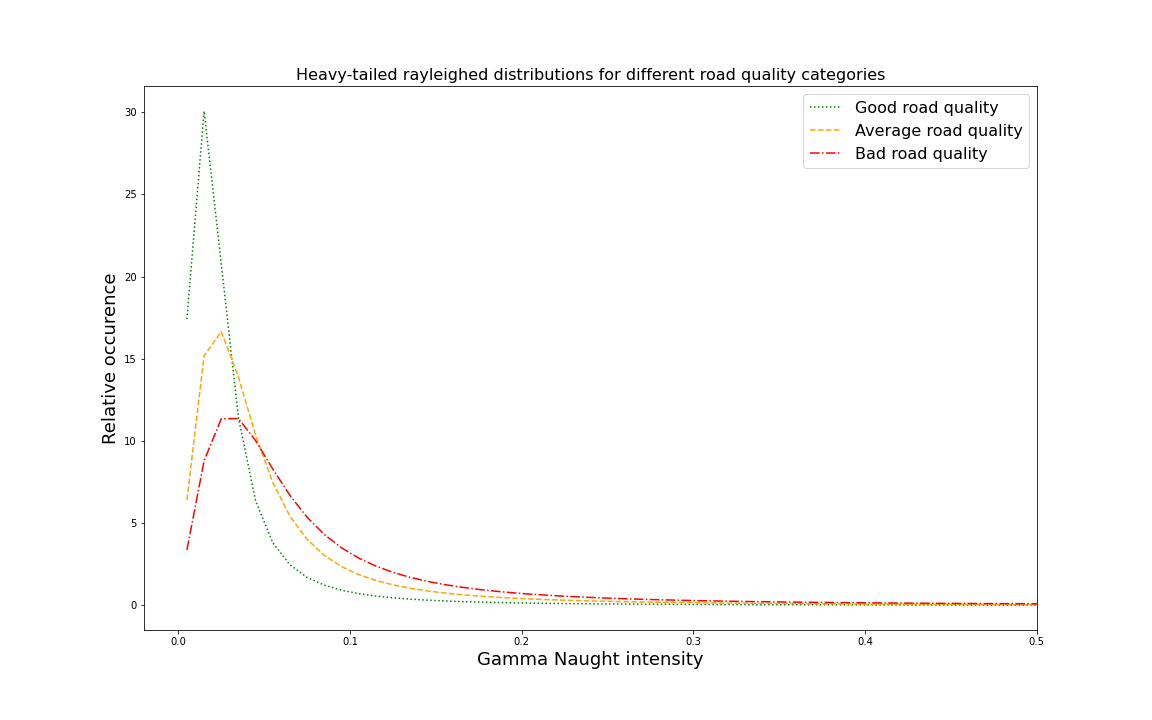
In this feasibility study, the potential of using SAR images to assess road quality was explored (both from technical and business angles). New methodologies were developed, modelling SAR intensity with a long-tailed Rayleigh distribution model, estimating IRI from smartphone accelerometer readings. Additionally, the proportion of 'clear' roads in Flanders was calculated, showing that up to a maximum 65% of Flanders' roads lack shadow and layover effects, making them suitable for SAR image-based modelling. For such roads, a correlation between SAR intensity and road surface roughness was found. However, due to the fact that ‘clear’ roads are disconnected, for a full coverage of an area other quality inspection methods will be required.
To further the study, the analysis should be performed on a larger scale. For this, a representative ‘ground-truth’ dataset is required, that indicates the quality and surface type of each road segment. No such open-source datasets exist yet.