Objectives of the service
Seqana's primary objective is to address the critical challenges facing the Monitoring, Reporting and Verification of Soil Organic Carbon (SOC) in carbon offset and inset projects around the world. The key challenge is the costly and time-consuming process of MRV, which can account for up to 30% of project operational expenses and delay project timelines by 6-12+ months. This hampers the implementation of SOC projects, compromising their potential contribution to climate stabilisation and thriving rural ecosystems and livelihoods. Seqana's solution is a Software as a Service that leverages Earth Observation satellite data, including sources like Google Earth Engine, ESA, NASA, and commercial datasets. It offers a cost-effective and highly accurate alternative to traditional soil sampling and modelling methods. Depending on the region, the solution provided can cut expenses by up to 90% and deliver results that are up to 10 times more accurate than existing modelling approaches like SoilGrids. Seqana's user-friendly platform will allow project developers to obtain credible SOC quantification from anywhere on Earth with just a credit card and a computer. This approach revolutionises the MRV process by significantly expediting time-to-market and easing the financial burden on project developers, supporting the implementation of climate change mitigation projects that offer multiple social, economic, and biodiversity co-benefits.
Users and their needs
Seqana's services cater to a diverse range of users and communities involved in various aspects of carbon credit projects, sustainability, and government policy. The service is deployed worldwide based on the client's geographical presence.
These users include:
-
Project Developers for SOC projects on the voluntary carbon market, who need affordable, reliable MRV solutions for projects in full compliance with current voluntary methodologies.
-
Agrifood Corporations with insettting and sustainability targets within their value chains and a need to accurately quantify the same
-
Governments and Public Entities, interested in scalable SOC quantification to inform policies and monitoring SOC in their territories, especially in remote areas
-
Precision Farming Platforms, who provide data and technology services to agricultural companies and need access to accurate and reliable remote SOC modelling for their clients.
Service/ system concept
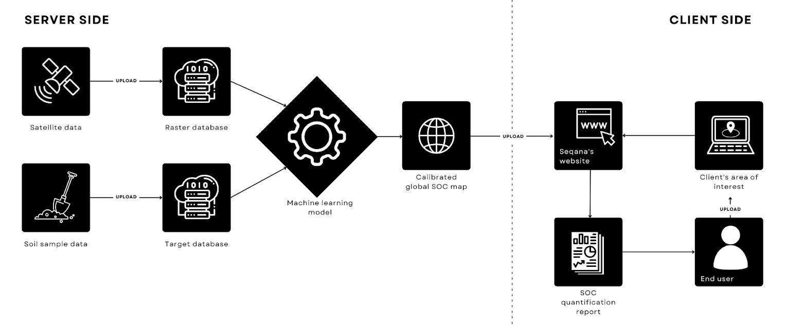
Seqana is building an innovative Software as a Service (SaaS) platform, empowering users to effortlessly access and submit Soil Organic Carbon (SOC) reports for their Natural Climate Solutions (NCS) projects. With user-friendliness at its core, the platform will allow for automatic downloads and submissions all from the comfort of one’s desk. These comprehensive reports include SOC values, accuracy metrics, and all necessary documentation for standard-setting agencies, establishing a robust baseline for future carbon accounting and monitoring yearly changes.
Seqana’s technology is underpinned by advanced machine learning algorithms and artificial intelligence, utilising satellite and Earth Observation (EO) imagery to model soil properties. This innovative approach ensures accurate predictions of SOC for various land-use types, calibrated meticulously with thousands of in situ soil sample data points. The quality, quantity, and distribution of these field measurements in our training database are paramount, directly influencing the performance of our models.
Seqana’s operational backbone consists predominantly of neural network models, capable of discerning complex relationships between field-measured SOC levels and satellite-derived predictor datasets. Upon identifying these patterns, the models proficiently predict SOC values in unsampled areas, aiming for precision across diverse land types, from grasslands and agricultural fields to grazing lands.
By integrating ground-truth soil samples with satellite data, Seqana’s platform will be an important innovation in remote SOC quantification, ensuring reliability and promoting global environmental stewardship. Seqana’s platforms paves the way for accurate, accessible, and efficient SOC reporting, fostering trust and compliance across the NCS project landscape.
Space Added Value
Seqana utilises satellite technology to streamline SOC predictions, reducing costs, sample requirements, and invasive methods. We combine in situ soil samples with satellite-derived predictor variables in machine learning models. These predictors are sourced from platforms like Google Earth Engine or developed by our team of experts. For the initial stage we rely heavily on Sentinel 1 and 2 data, as well as some proprietary data from emerging constellations.
Once trained, the model deploys on our Google Cloud Platform, enabling SOC predictions for specific years, areas, and soil depths. This approach harnesses space assets efficiently, outperforming traditional methods with reduced costs, non-invasive procedures, and broader applicability.
Current Status
As of October 2023, Seqana has concluded all project activities
Achievements:
-
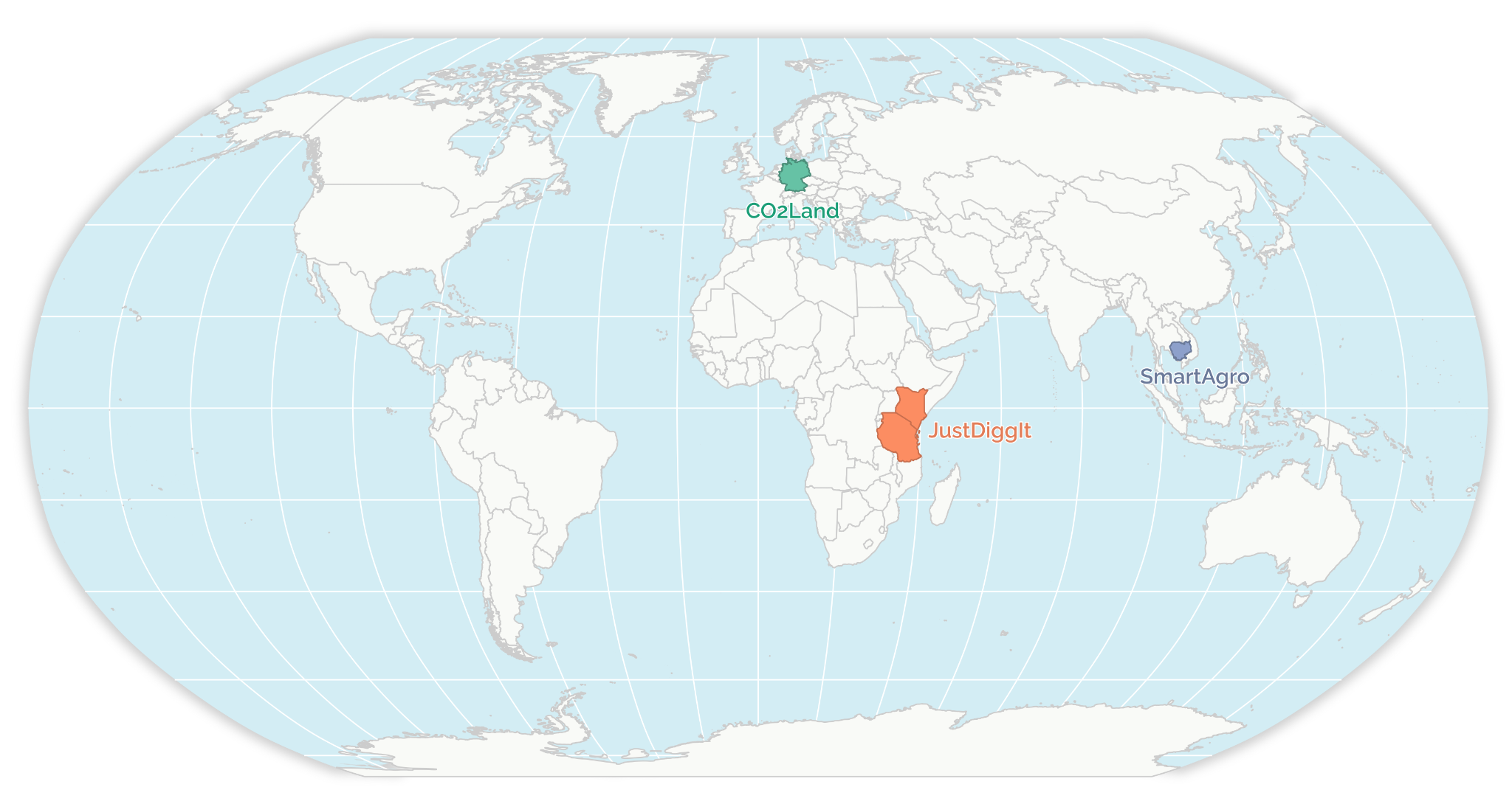
Established Memorandums of Understanding with SmartAgro and its local partners in Cambodia, JustDiggit in Kenya/Tanzania, and CO2Land in Germany, forging valuable partnerships.
-
An existing dataset from the Department of Agriculture and Natural Resources Management (DALRM) in Cambodia was acquired, bolstering project data resources.
-
Collaborating with SmartAgro and CIRAD, Seqana organised the laboratory analysis of 1693 soil samples from Cambodia.
-
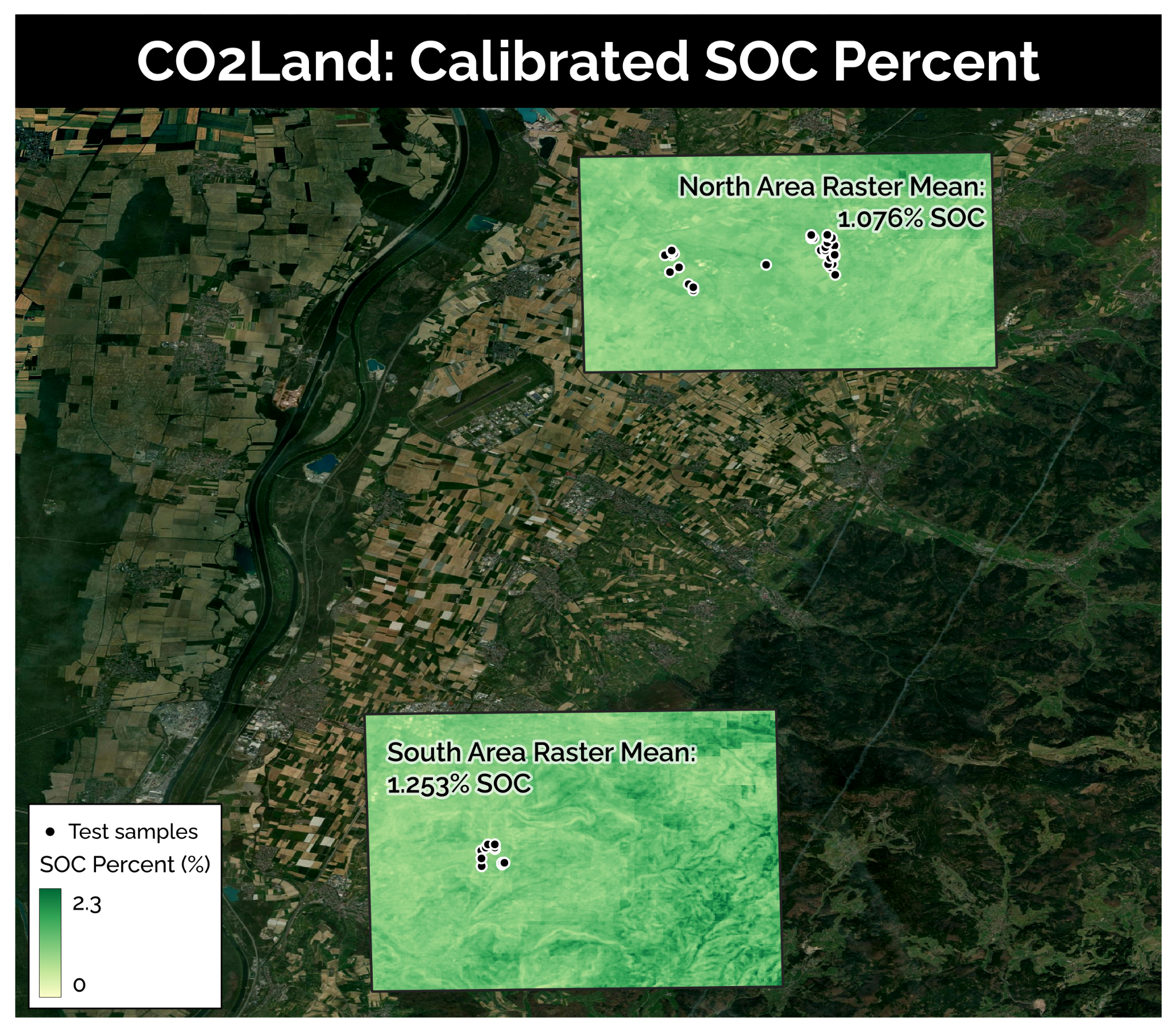
The laboratory analysis of approximately 328 soil samples from Baden-Württemberg, Germany, in 2021 and 2023 was coordinated with CO2Land, contributing to a diverse dataset.
-
Coordination and laboratory analysis of 319 existing soil samples from Kenya and Tanzania in 2022 took place in partnership with JustDiggit, further enriching the dataset.
-
Seqana calibrated models for each region of interest using the new datasets generated during the project.
-
These calibrated models were tested on previously unseen data to estimate their new residual error values when compared to ground truth data.