

Objectives of the service
Floating-leaved aquatic weeds can rapidly clog up lakes, reservoirs and navigation canals, leading to major economic impacts for businesses, fisheries and leisure activities. Their growth and spread is a particular problem in freshwaters in tropical and sub-tropical regions. As free-floating weeds can move rapidly with winds, providing a frequent and complete picture of their coverage across the whole waterbody surface is key to inform boat access and target weed control programmes. Frequent updates are key to provide early warning of weed problems in new locations.
Floating Weed Manager is a service for biologists, field surveyors and waterbody managers to monitor and control invasive plants.
It supplies up-to-date maps and statistics of floating weed coverage for targeted and timely treatments:
-
Floating weed maps every 2 - 5 days, with whole-waterbody cloud-free maps every 1 - 2 weeks.
-
Total vegetation cover maps every 12 days regardless of cloud cover.
-
10 m spatial resolution and an accuracy of 80% or better.
-
Change maps, summary statistics and time series data from 2016 onwards to evaluate treatment efficiency.
Delivery is within 48 hours of satellite image acquisition.
It offers mapping for user defined areas within lakes, and rivers and canals (> 10m wide).
The service provides data visualisation and download through an interactive web portal, or API.
Users and their needs
The targeted user communities are primarily national or regional agencies tasked with overseeing and managing weed control programmes. Typically, these users will be obliged by legislation, as well as necessity, to control floating weeds, e.g. our champion customer, the US Army Corp of Engineers, (USACE), Florida, USA. Users also include regional administrations that strategically manage water bodies within their area, this includes city or state level organisations; e.g. Biosecurity Queensland, Australia.
Other users include external consultants that give advice on controlling weeds and carry out weed control programmes (e.g., The Center for Aquatic and Invasive Plant Management, Florida, USA; CABI Kenya; and Rhodes University, South Africa), and users that access water bodies for recreation or work (e.g., commercial and recreational fishermen, water sports businesses or enthusiasts). By accessing weed cover maps, these users can identify when and where their water bodies are accessible.
The challenge for the project is to be able to distinguish free-floating plants from emergent vegetation and provide map updates at a high frequency (weekly).
Service/ system concept
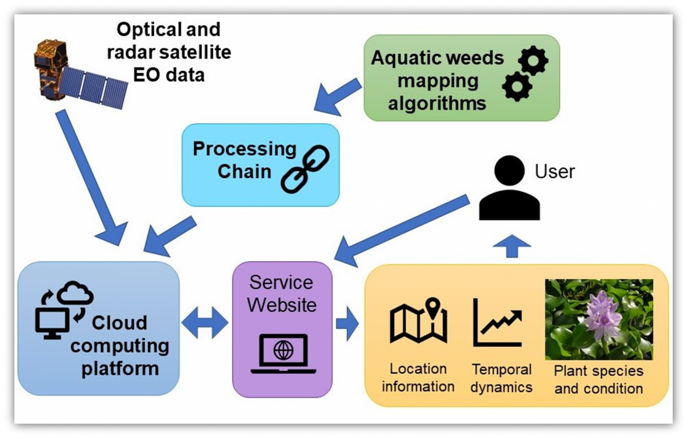
Radar data will be used to deliver dependable weed maps, unaffected by cloud cover, at approximately weekly frequency. Optical data will supplement that to provide a higher frequency of survey and help differentiate floating weed species from emergent vegetation and potentially measure flowering and plant health. The Service involves a processing chain that delivers products online through a friendly user-interface within 48 hours from satellite data acquisition.
Space Added Value
Currently surveys of floating weeds are carried out from boats or helicopters, typically surveying whole lakes at a monthly frequency at best. The service will use a combination of ESA Sentinel 1 radar and Sentinel 2 optical images. Combining these two assets, the service will supply more comprehensive and more frequent (weekly) vegetation maps than existing “ground” surveys and provide enhanced quantification of weed population coverage and weed health. The service could also incorporate optical imagery from commercial satellites (e.g. Planet) to provide finer spatial resolution (3 x 3 m) and higher frequency updates.
Current Status
Following on from the feasibility study (2020-2021), we have embarked on the demonstration phase (April 2023 – April 2024).
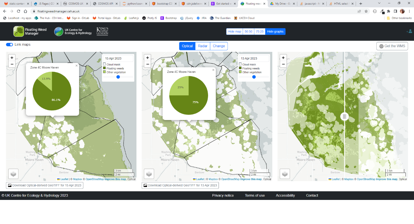
We worked on operationalising our processing chain and we now have a working Floating Weed Manager service pilot with a web portal providing a time-series of floating weed and vegetation for 2022-2023 for Lake Okeechobee. A snapshot of our online portal is shown below. It is the result of a couple of iterations already and the plan is to improve and refine the portal further using monthly feedback from our champion customer (US Army Corps of Engineers, USACE).
In July we travelled to Florida to join USACE at one of their regular interagency meetings, experience Lake Okeechobee’s ecosystem in person, and spend time discussing USACE’s and others’ requirements and challenges in detail.
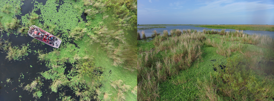
Examples of invasive floating lettuce (above) on Lake Okeechobee (Florida - July 2023).
Next we will be testing the service in-house before handing it over to USACE for testing and feedback at the beginning of October.