
Objectives of the service
Among the different types of insurances, the ones covering natural disasters, such as floods or wildfires, and extreme weather events, such as storms, hail or droughts, are the most difficult to be managed because of their precarious nature. In this particular context, farming is one of the businesses that are mostly affected by natural disasters and extreme weather events. Insurance has attracted much policy attention as a tool for building resilience to extreme weather events by providing financial compensation for losses and incentives to reduce risk. Thus, in the eventuality of a disaster, most property owners holding insurance will have the opportunity to file claims with their insurance companies for the damage incurred. From this point of view, the occurrence of a natural disaster or an extreme weather event may offer the opportunity for some individuals or organizations to file claims that are either inflated or completely fabricated in order to profit. In some cases, fraudsters even intentionally damage property after a disaster in order to receive a higher payout.
Users and their needs
Claim management is undoubtedly one of the insurance pillars and also one of its major critical points, both for the complexity of its management and also for its sensitivity, being the most important contact-point with the customer. The management of the claim is, for a company, the moment of truth in its relationship with the customer: if, with respect to the latter, the entire compensation process is effective, fast, transparent, satisfactory, nothing is worth more for the loyalty of the customer himself. The challenge is even more demanding today, because customer expectations have evolved, have grown, what was once a 'hope' for the customer, is now a fair one, a claim which, if disregarded, leads the interested party to change Company as easily as changing a channel on TV. Thus, for insurance companies insuring crops, it would be beneficial to:
-
Improve efficiency
-
Reduce frauds
-
Reduce operating costs
Service/ system concept
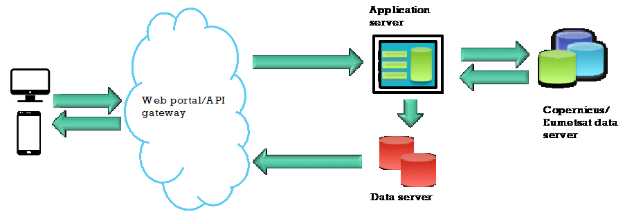
AIperion is an SaaS system that permits to:
- Estimate the damages occurred in agricultural fields due to severe weather events
- Identify and detect the boundaries of flooded areas
- Identify and detect the boundaries of burnt areas
- Quantify in terms of extension and duration the drought areas
AIperion is based on deep learning techniques applied to EO and Meteo data. The service is based on API REST services.
Space Added Value
The AIPerion project relies on the use of images acquired by different Earth observation missions. Different EO data are used depending on the type of service. For the Identification and detection of flooded areas, the system will use data from Sentinel-1 and Sentinel-2 missions. Sentinel-1 permits to detect the boundaries of the flooded area, while Sentinel-2 is used to estimate anomalies in the crops that have been flooded. The detection of burned area takes advantage of the SWIR bands of Sentinel-2, while for the estimation of the damages in agricultural fields due to hailstorms, uses Sentinel-2 Sentinel-1 Polarimetric data as well as meteorological data from the MSG mission. The detection of droughts is more complex and requires the synergic combination of both data from Sentinel-2 in order to extract water indexes, and Landsat-8 thermal band to identify temperature differences. At present AIperion is an SaaS service that produces maps in a completely automatic mode. Different from other similar services on the market, AIperion doesn’t require any human interaction.
Current Status
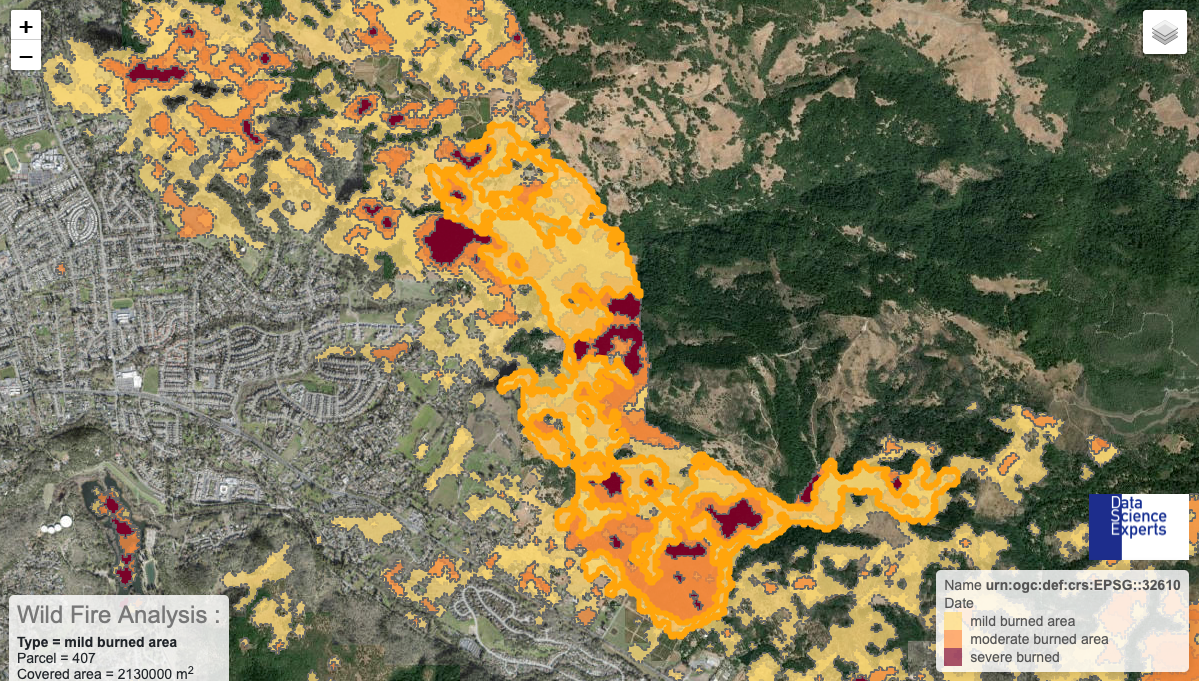
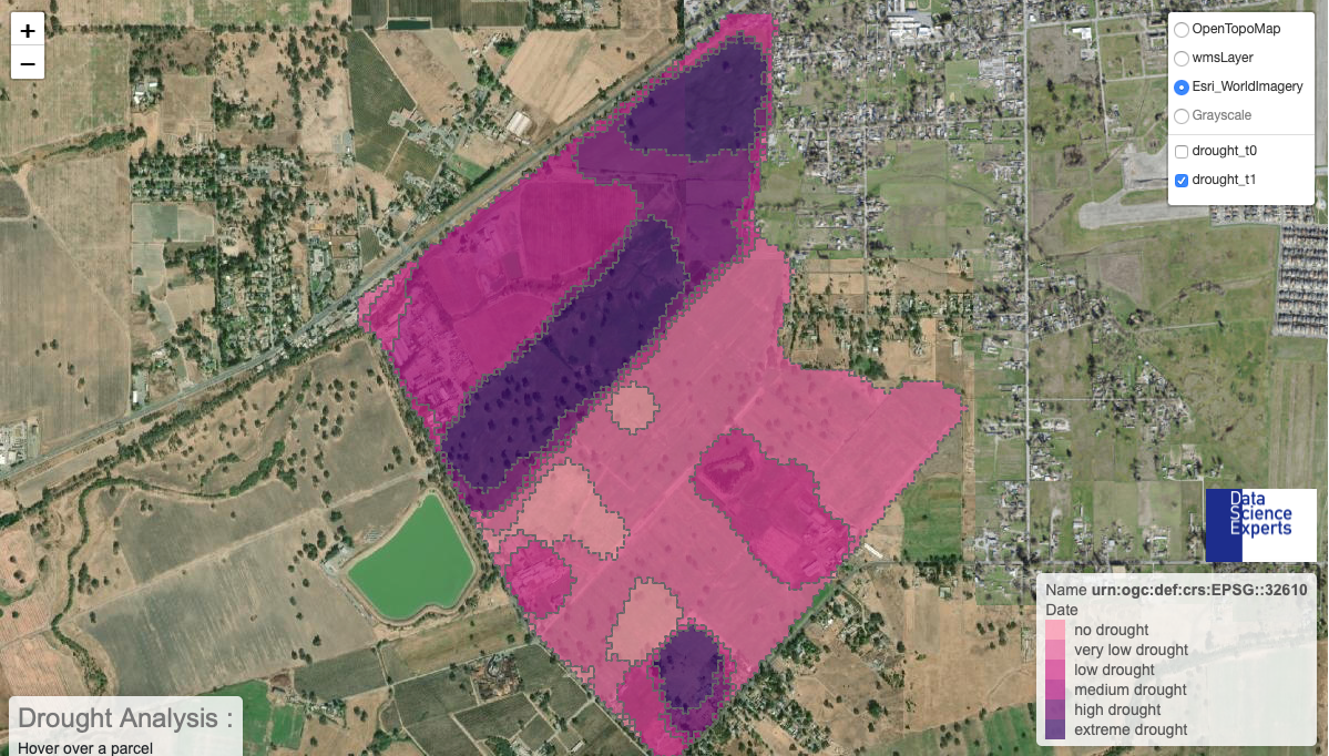
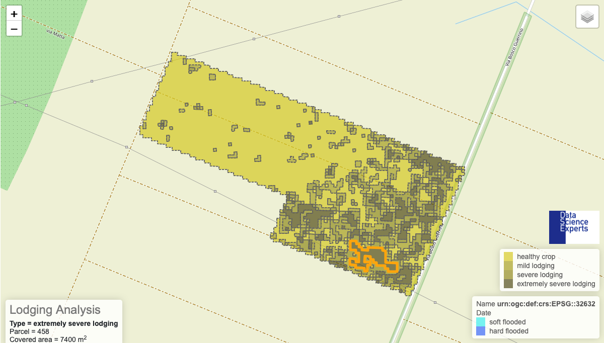
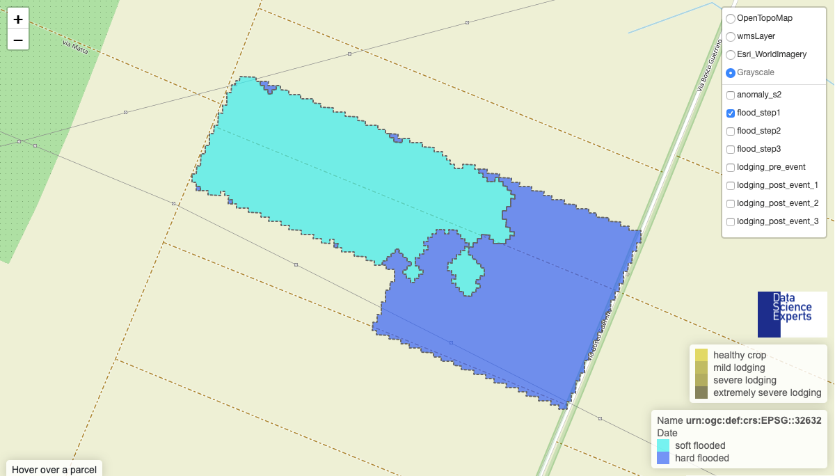
At present a first MVP has been released with reduced functionalities. The flood detection is complete and permits to detect the boundaries of the flooded area, the lodging (bending of crops) as well as the growth status of the crops after the event. Burnt area detection is complete too and permits to detect the extension of areas affected by wildfires according to a scale of three values depending on the severity of fire. Drought and hail services are complete at 50% and need to incorporate the meteorological data.