
An offshore pollution monitoring solution, based on expert interpretations of satellite imagery, is helping to make our marine environment cleaner. By alerting offshore industries to any unusual slicks or discharges, CGG’s SeaScope, developed with the support of ESA Space Solutions, accelerates response times to minimise risks and potential impact.
Pollution incidents can present a significant risk to the many industries operating offshore because any resulting impact on the local marine environment can have far-reaching reputational and cost implications. A system that offers early detection and qualification of anomalous pollution beyond normal discharge levels could not only help to ensure a timely response, but also minimise any related exposure and vulnerability.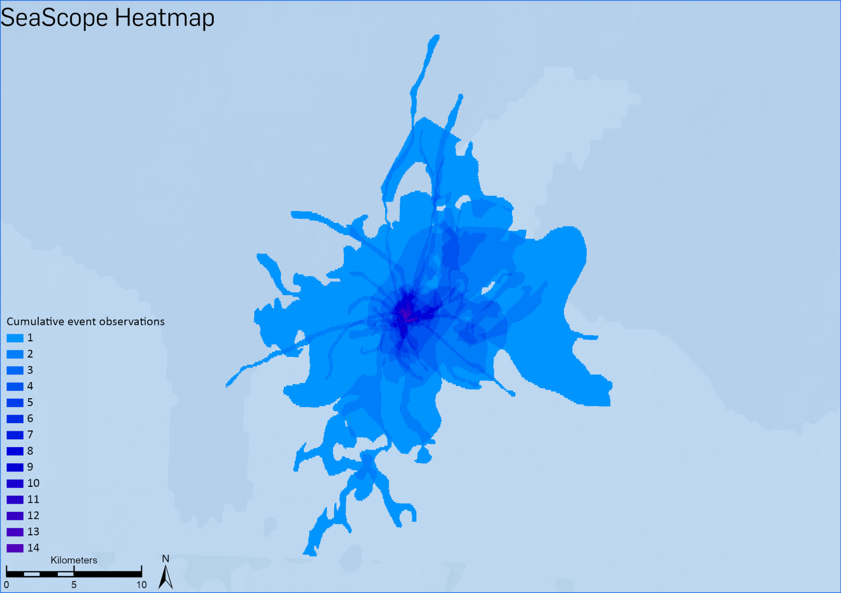
SeaScope meets this need by using satellite Earth observation (EO) data to provide critical intelligence about sea surface slicks. It gives users greater visibility over the interaction between offshore assets, coastal facilities, vessel activity and the local marine environment, which is vitally important for strengthening situational awareness and informing oil spill response activity.
“SeaScope is the latest innovation in our portfolio of environmental monitoring solutions. Its value lies not only in helping offshore industries to respond quickly to events, but also to mitigate risks and support their environmental and operational transparency commitments,” says Peter Whiting, SVP, Geoscience, EAME, CGG.
Combining satellite data for actionable intelligence
Developed by CGG Satellite Mapping with the support of ESA Space Solutions, SeaScope integrates two types of space assets: EO imagery and satellite-derived ship location (AIS) data. EO imagery is interpreted by CGG’s experts to monitor the ocean surface for offshore slicks and determine their extent. The AIS data provides knowledge of ship location and activity, and is used to link slicks with vessels in the area. Combining these technologies generates high-quality, reliable intelligence alerts on anomalous events to offshore infrastructure operators, significantly enhancing their ability to understand the occurrence and evolving behaviour of nearby pollution events.
![Vessel pollution in the Red Sea captured by the ESA Sentinel-1 satellite (contains modified Copernicus Sentinel data [2021]) (image courtesy of CGG).](/sites/business/files/redsea.jpg)
SeaScope was developed from 2018 to 2020 as a Demonstration Project as part of the ESA Space Solutions Integrated Applications Promotion (IAP) programme. Over 3020 medium and high-resolution satellite radar scenes were processed and interpreted across infrastructure in the North Sea, Gulf of Mexico and South East Asia. The results (10 750 unique events) were either integrated into client systems or made available via an online portal.
Key to the success of the Demonstration Project was the ability to provide standard geospatial data with clear reporting statistics to emergency response teams, who often have responsibility for multiple offshore assets globally. End-users receive targeted information supported by clear visual data showing the location and extent of any slicks within the SeaScope geographic database. A heatmap showing slicks over time quickly informs operators of anomalous events beyond normal discharge levels. The results provide critical, timely intelligence to multiple operational teams.
Evidence base of responsible operations
SeaScope’s proactive monitoring enables companies with offshore assets to establish production water baselines and provides early detection of anomalous events and third-party pollution incidents, as well as surveillance of natural seeps. It also supports the creation of an evidence base of responsible operations for stakeholders, such as operators, regulators, investors and insurers.
“SeaScope delivers a highly scalable remote monitoring solution to identify individual offshore pollution events or verify clean activities across global asset portfolios. The CGG team will continue to develop the analytics surrounding the growing SeaScope database to provide further insights for our user clients,” says Whiting.
SeaScope from CGG on Vimeo. SeaScope uses satellite data from a number of providers to deliver information about sea surface slicks, including data that can be used to provide evidence of responsible operations.
ABOUT ESA SPACE SOLUTIONS
ESA Space Solutions is the go to place for great business ideas involving space in all areas of society and economy. Our mission is to support entrepreneurs in Europe in the development of business using satellite applications and space technology to improve everyday life. ESA Space Solutions is designed to provide multiple entry points such as ESA Business Incubation Centres (ESA BICs), ESA Technology Broker Network, ESA Business Applications Ambassadors and ESA Business Applications programme. Funding typically ranges from €50k to €2M and supports everything from technology transfer, business incubation, Feasibility Studies to large-scale Demonstration Projects.