
Calculating accurate water levels in rivers and reservoirs is not always straightforward, especially when the rivers in question are ungauged or the reservoirs are managed by third parties. WatAspace is a Feasibility Study led by Waterjade and funded by the European Space Agency (ESA) under the ESA Business Applications and Space Solutions (BASS) programme. The project uses satellite data to estimate water levels and was successfully completed within twelve months.
Currently, river flow monitoring still relies on data which is collected and analysed from in situ stations which are installed at selected points of interest. Maintaining and supporting these stations is difficult and costly and is especially challenging in remote areas. As a consequence, their numbers have decreased in recent years, just as climate change has made the need to understand water flow in these more remote areas all the more urgent. Recognising the need to find a solution, WatAspace set out to tackle these limitations by using a multi-model, multi-data approach.
The first step was to take satellite images from different sensors to supplement and enrich the information from the in situ sensors and to improve the update frequency. At the same time, meteorological data provides valuable ancillary information which can be used in tailored machine learning algorithms and physical models.
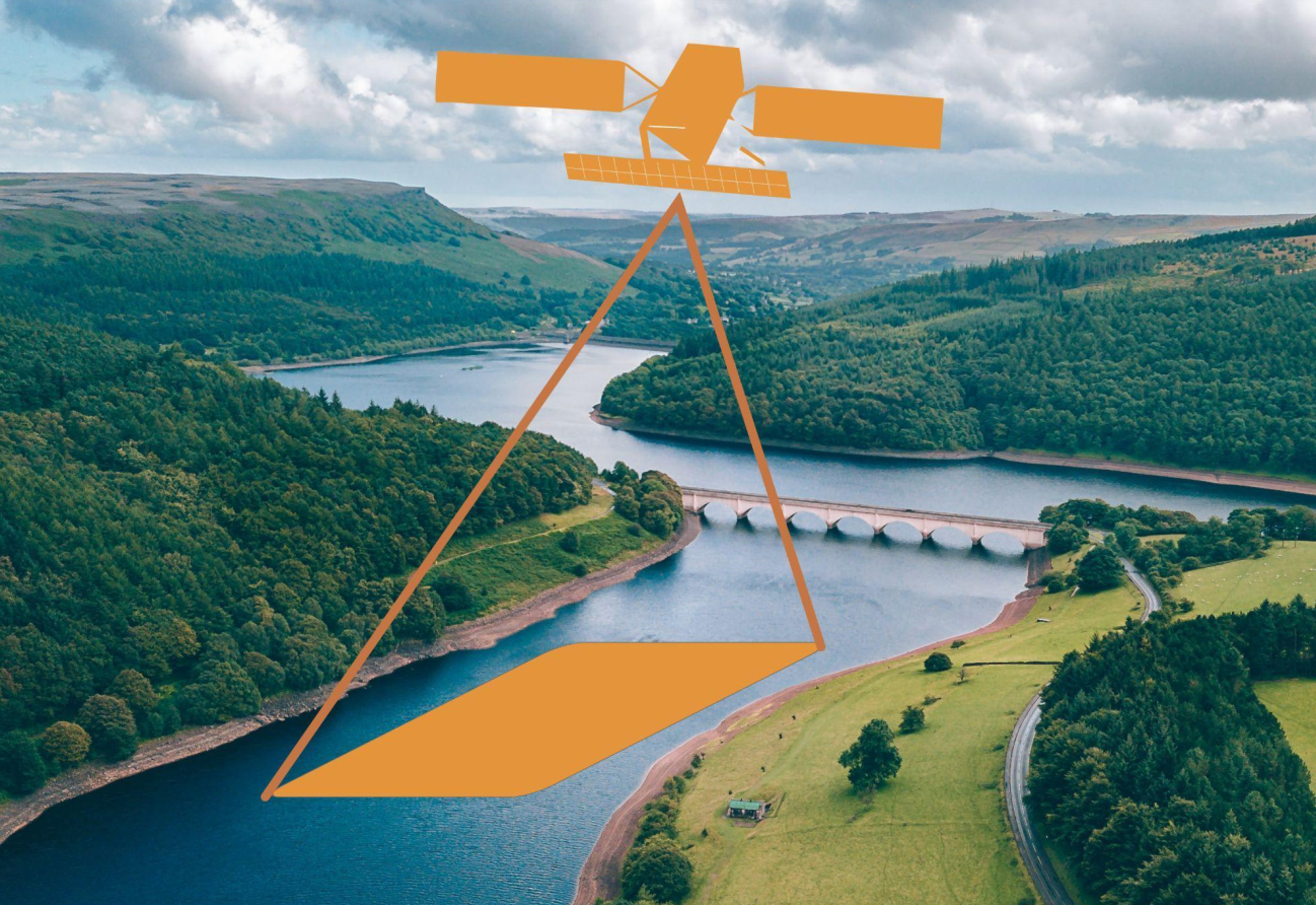
WatAspace technology uses three different sets of satellite data to create a unique picture of the status of a waterbody: radar altimeters provide a direct measurement of water level in rivers or reservoirs, optical sensors provide multi-band images containing different information about the water extent and shape of the water body, and Synthetic Aperture Radars provide images in which water bodies can be easily identified in dry areas.
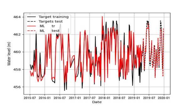
By using these three techniques together, WatAspace merges the best of the different technologies and uses a dedicated AI infrastructure to provide a robust and comprehensive dataset. Once calibrated, the EO-retrieved hydrological quantity shows a high level of alignment with the gauged signal.
Federico Di Paolo from Waterjade said “The funding from ESA Space Solutions has been key to the success of the project and the team gave us their full support with regular mentoring sessions. We received vital feedback on the processing chain for the satellite images from the technical team, and ESA also helped us to better refine our value proposition.”
Francesco Feliciani, Head of the Company-Led Projects Section at ESA Space Solutions said, “This has been an exciting and complex project highlighting the value of space in monitoring water flow in remote areas. We look forward to continuing our collaboration with Waterjade in this area.”
The study has so far focused on test sites in Italy, with a view to extending the trials to water body sites around the world. A commercial validation exercise produced a range of positive interest and requirements from industry, in particular from the water utilities and irrigation services, hydropower companies and government agencies.
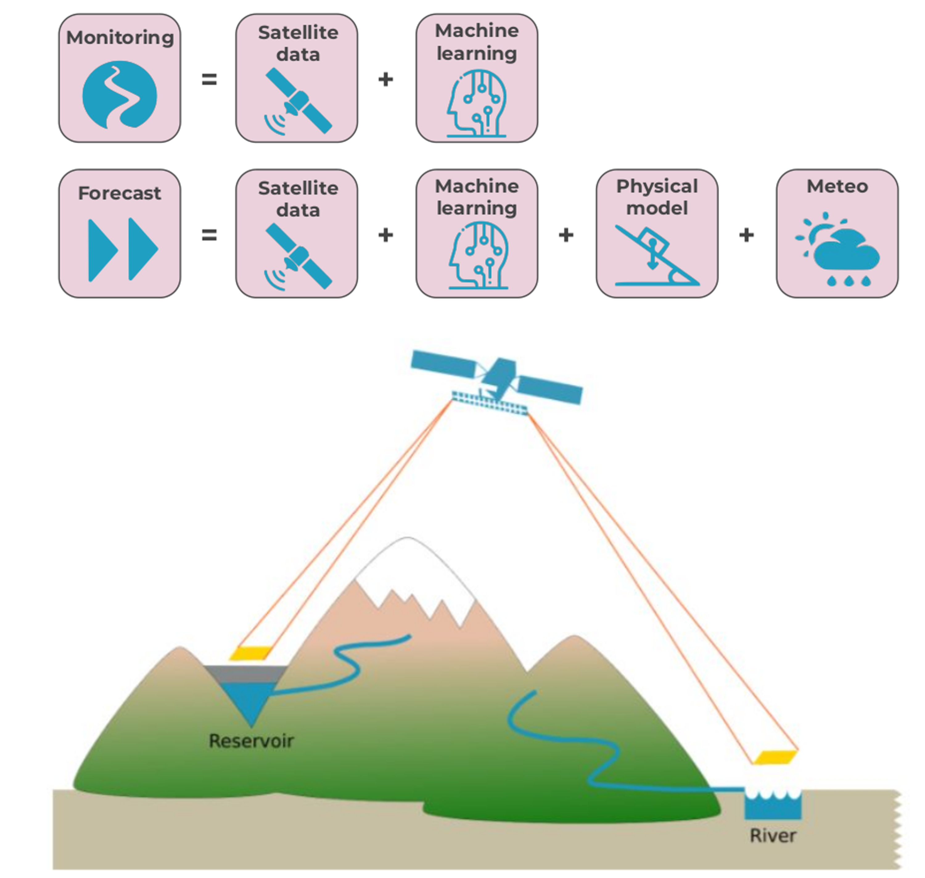
Waterjade now plans to develop prediction services using the techniques developed in the Feasibility Study. The modelling chain would be trained on historical river level data extracted from satellite images, representing a unique data source with the potential to be made available on a global scale. The prediction service will supply water inflow forecast for several days, based on numerical weather prediction. Eventually, Waterjade has the potential to be able to predict water flow in rivers and water level in reservoirs for longer periods, up to months in advance, taking into account the meteorological forecasts and the current status of the upstream catchment.