Objectives of the service
The WATERLENS services aim at helping water utilities to improve infrastructure maintenance planning and follow more easily the evolution of the regulatory and contractual contexts. These services provide state-of-the art screening and monitoring tools to efficiently manage the aging infrastructure and the complexity of the water pipeline network.
The services offer a new and cost-effective approach for the monitoring of large water management infrastructures. They are based on multiple space assets such as Earth Observation and global Satellite Navigation systems. They combine observations through satellites and remotely piloted aircraft systems (RPAS) and tools for data management, analysis and visualisation relying on advanced image processing techniques. The services are integrated into a service management platform, which allows the user to investigate the infrastructure and its surroundings in detail, with high spatial and temporal resolution. Monitored parameters are available on maps or charts, after they have been extracted from satellite or RPAS data and analysed to provide actionable information.
Key issues for the sustainable operation of such services are costs, regulations (e.g. for RPAS), market structure, user’s acceptance and sensitivity to price vs. benefit as well as the identification of early adopters.
Users and their needs
The targeted user community comprises water management companies and water resource monitoring institutions. Major users belong to the water management industry or services, being private, institutional, associations or individual users:
- Companies involved in businesses with water distribution, supply, treatment and water pipe networking;
- Government agencies;
- Agriculture;
- Companies involved in the prevention of water related disasters;
- NGOs or international organisations involved in installation of water extraction and distribution in developing countries.
Their activities include monitoring of infrastructural assets following a risk-optimisation approach. Such infrastructures can be large, complex and critical. Due to financial and technical constraints, a suitable monitoring of the network and its changing environment is often only partially and infrequently conducted. Users are also confronted with the pressure on increasingly scarce water resources, unfavourable changes of the land usage within the drainage basins, generally changing environmental conditions, increased cost of water extraction, amount of non-revenue water and the threat of third party damages.
Users are therefore looking for cost-effective alternatives or complementary services to better assess the risks and reduce the impact of failures through early detection.
User’s main needs are listed below:
- Relevant parameters on state and risks observable from space or through aerial surveys;
- Information on potential risks at high spatial and temporal resolution;
- Coverage of medium to large areas;
- Indirect assessment of phenomenon such as human activities or natural hazards;
- Temporal consistency and systematic documentation.
TARGET COUNTRIES
Industrialised countries are the primary target market for the WATERLENS services. Currently it includes the UK, Portugal, Germany and France, but expression of interest has been received also from other countries such as Croatia, Serbia, Armenia, etc
Service/ system concept
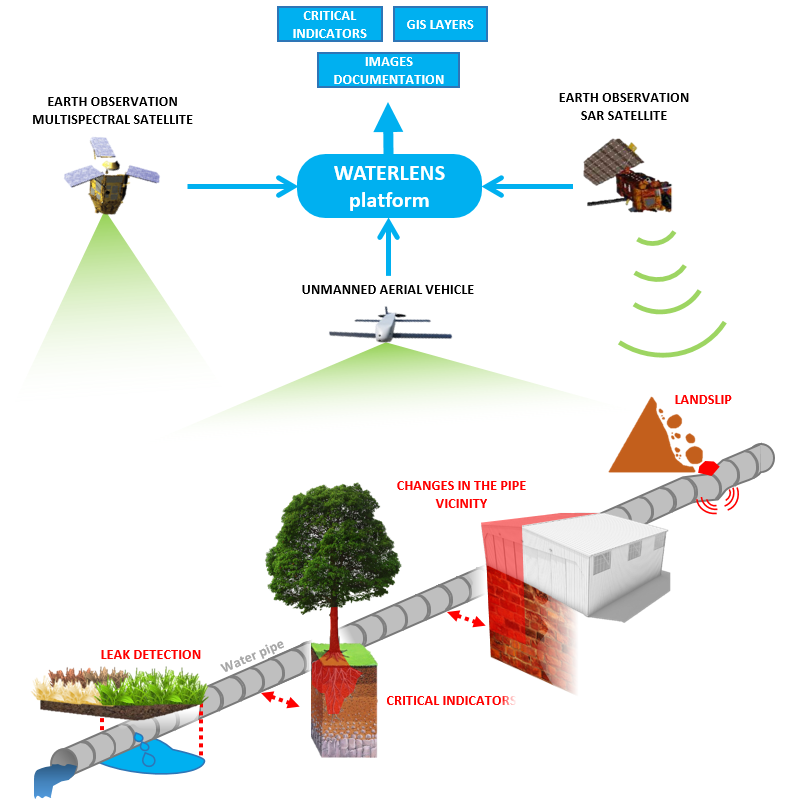
Four promising WATERLENS services have been identified:
- Detection of critical elements and land use/activity changes in easement for water pipelines (e.g. vegetation encroachment, building extension, abandoned car, construction site, excavation or other disruptive activities in the vicinity of water pipelines)
- Detection of topography changes near water pipelines (e.g. soil subsidence, landslides)
- Detection of potential water pipeline leakages or bursts
- Overview mapping of reservoir surroundings and entire drainage basins (e.g. for reservoir maintenance planning, improved run-off modelling, water supply quality assessment, etc.)
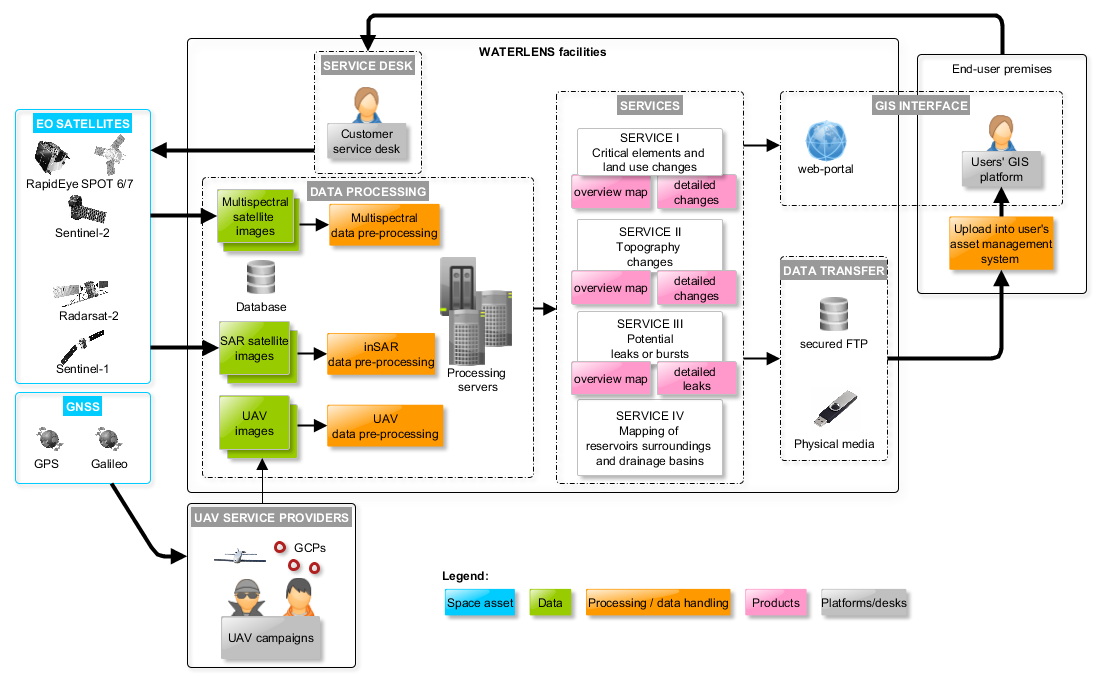
For the selected services, routine procedures have been defined in order to assess water distribution infrastructure threats and integrity. Data is collected through Earth observation satellites (optical and radar) as well as Remotely Piloted Aircraft Systems (RPAS). Their exploitation offers more frequent and systematic information at lower cost than traditional approaches. A set of tailored exception reports will be provided to the users (e.g. risk areas) in a geocoded directly GIS ingestible format, supporting risk analysis and planning of interventions.
Space Added Value
The Space added value lies in the power of global observation means provided by EO satellites and in GNSS services that are used to precisely guide RPAS along pre-defined paths.
The space assets used by WATERLENS services are:
- Earth observation for global monitoring of water resources and other elements that could impact their infrastructure and their environment.
Satellite navigation (GNSS) to enable autonomous RPAS operation and to support the surveying of ground reference points.
Current Status
The study has been completed successfully with the Final Review held in June 2015. The study comprised the gathering of users’ & stakeholders’ requirements, the analysis of existing services and technological building blocks, and the identification of gaps between the user requirements and the current state-of-the-art technologies and processes. The financial and non-financial viability analysis paralleled the definition of services and has been completed.
The technical work has been completed and critical parts of the services have been tested and exercised in a proof of concept. Product prototypes have been provided to selected users to evaluate their technical and functional relevance.
The commercial viability of the different services has been positively evaluated, although some risks were identified and taken into account in the analysis.
The last phase of the study has led to a roadmap to implement the proposed services. A follow-on demonstration project within ESA’s IAP Programme is currently under discussion/preparation.
The results of the feasibility study were presented at the IWA Water Loss Management conference 2015 (http://waterloss2015.araexpoapa.ro/en/).
Prime Contractor(s)
Subcontractor(s)