Objectives of the service
URGED addresses an increasing global requirement for the provision of better predictive decision support tools for urban infrastructure managers to enable cities to become more resilient to the environmental and social threats. These Earth Observation (EO) derived Data Products, analytics and monitoring tools identify where there is the likely high risk of subsidence and flood risk via online, interactive maps, to improve infrastructure planning and management and reduce operational costs.
This new opportunity has emerged through the escalating need for cities to become more resilient, and the availability of new satellite data sources such as Sentinel 1 and 2, combined with the evolution of Rezatec’s EO analytical capabilities, such as SAR interferometry.
Combined with the delivery of subscription based access to dynamically updated analytics as a service, this represents a new commercial model that has greater scalability and price advantages than current consulting based approaches to managing urban subsidence and flooding issues.
The project aims to have a profound contribution to city-regional economic, environmental and human wellbeing by demonstrating the value of space data in enabling strategic investment and decision making to support more resilient development pathways.
Users and their needs
Targeted user communities and their uses for URGED are:
1. Water Utilities, who use URGED for:
- Pipeline Failure Risk
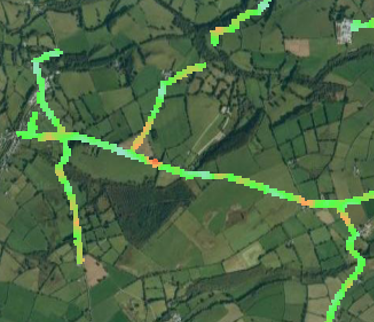
- Terrain Motion: DInSAR methods to monitor ground movement;
- Vegetation encroachment: Modelling rooting zone extent and depth as a potential threat to the structural integrity of the pipeline network;
- Inherent pipeline risk: Use of historic burst, leak event data associated with corresponding pipeline attributes to model individual pipe segment failure probabilities.
2. Urban Infrastructure Management, who use URGED for:
- Soil moisture monitoring: to identify locations that indicate elevated soil moisture that might indicate leaking canal infrastructure;
- Flood hazard: Downslope risk modelling based on the best available digital terrain data to identify locations where potential infrastructure failure may result in significant damage to built-up areas
- Terrain motion: to monitor the extent and rate of subsidence events in and around canal infrastructure;
3. Town /City Authorities, who use URGED for:
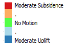
- Mapping Urban Green Spaces
- Green Spaces have an important role in the urban environment providing:
- Recreation and tourism locations; and
- Controls on urban climate including temperature and air quality
- Closer proximity to green space is associated with increased health and wellbeing in the city population
- Rezatec provide green space analysis with rapid repeat mapping available to track changes in green infrastructure presence and accessibility
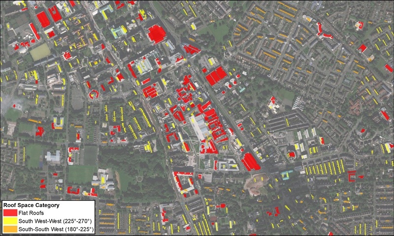
- Mapping Urban Roof Spaces
- Contiguous urban roof spaces mapped by slope and aspect
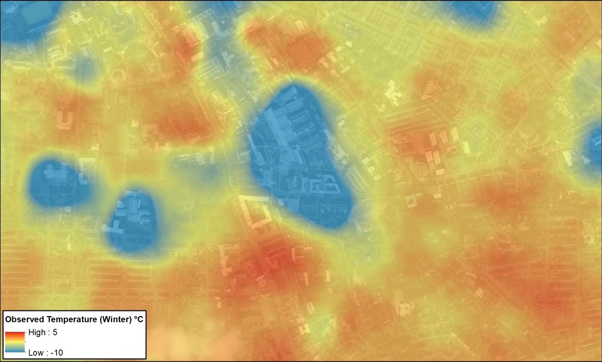
- Thermal Monitoring
- Surface Temperature measurements show well insulated efficient commercial buildings (blue) versus less efficient primarily residential properties (red)
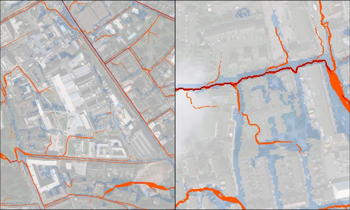
- Flood Risk
- more detailed analysis of flow pathways (orange-red) around key buildings and infrastructure complementing existing Environment Agency Surface Water Flood Risk mapping (blue)
The URGED platform is a global service. For the Demo project, the pilot implementations are being executed in the UK due to the location of the end users however the Data Products have global commercial potential.
Service/ system concept
The URGED platform is built on top of existing system and service architecture but with new and crucial additional development to support the URGED services:
- Geospatial Data Product Methodology (Product Management) created to address the urban resilience challenges associated with subsidence and flood risk.
- Flood Hazard, Exposure, Vulnerability
- Land surface movement hazard, exposure and vulnerability
- Data Processing and Data Management to build and aggregate maps of the area of interest, derived from multiple sources including original mappings in addition to Earth Observation data and ground data.
- Predictive Analytics Toolkit and Analytic Services based on Earth Observation data, automated image processing techniques and diverse geospatial analyses employed to create analytical data for urban landscapes.
- Primary data products
- Secondary data products
- Data Marts Output Interface to resilience.io to enable open-access to URGED data products for both commercial and non-commercial applications and will stimulate the market for higher value restricted-access URGED products.
- URGED Portal is a security-enabled web application which acts as a user friendly client to access data products and is the primary method of data delivery and enables users to search, view, interrogate and download geospatial datasets.
Space Added Value
The URGED system makes use of the following three components, of which there are no potential alternatives:
- Earth Observation (EO) data, to cost-effectively support scalable assessments of subsidence and flood risk using a mixture of sensor types including Optical, Synthetic Aperture Radar (SAR), Thermal Infra-Red and LIDAR. EO images will be sourced from a variety of satellite providers, according to the attributes required;
- Global Navigation Satellite System (GNSS) devices for accurate geo-referencing of the ground data used for calibration of the EO-based signatures; and
- Satellite Communication (Satcom), to collect and send ground data from locations where mobile network coverage cannot be relied upon (e.g. cities in areas will ongoing terrestrial communications infrastructure development), for time-efficient centralised calibration of the EO-based signatures.
Current Status
The URGED Demonstration Project has developed to the operational service with a global commercial potential. The project kicked off in May 2016. URGED addresses an increasing global requirement for the provision of better predictive decision support tools for urban infrastructure managers and water utilities. Analytics and monitoring tools identify where there is the likely high risk of subsidence and flood risk and deliver the information via online, interactive maps, to improve infrastructure planning and management and reduce operational costs.
The end users for the pilot implementations are: Welsh Water, Wessex Water, AMEC Foster Wheeler and The Ecological Sequestration Trust (TEST).
The Final Review Meeting was held on the 2nd November 2017.
Prime Contractor(s)
Subcontractor(s)