
Health
Health is a very broad theme involving a wide range of actors spanning across almost all types of institutions, all contributing towards maintaining and improving health of the citizen. A surprisingly large number of services can potentially be improved or newly created by introducing space-based systems to applications like disease prevention, to early warning, diagnostics, and treatment.
ABLE ACTIVE
Status date: 17 April 2024
ABLE ACTIVE promotes accessible trails and amenities to people with disabilities, uniquely by disability. Feedback captured from users helps to inform and inspire, making it easier for others to find opportunities suitable for their specific needs, and helping amenity operators to better understand and support their user community.
PASTA
Status date: 08 April 2024
The world health organization has reported that 7.6% of patients in high-income countries acquire a healthcare-associated infection (HCAI). Recent studies show that more than 650,000 patients a year in England acquire HCAIs, which cost the NHS over £1 billion annually. Airborne transport is responsible for up to 10% of all HCAIs. The PASTA solution aims to improve indoor air quality and to minimise the risk of airborne pathogen infection in future hospital environments using low-temperature plasma technology that is oriented from in-situ resource unitisation in long-duration space missions and space propulsion (Pulsed plasma thruster). This new technology is designed to provide better infection control for airborne pathogens. It can also reduce the carbon footprint of hospitals by improving the energy efficiency of a traditional HVAC system.
Colibri
Status date: 04 April 2024
Colibri is an operational telemedicine solution relying on satellite broadband communication to efficiently support healthcare services in white areas, combining fix telemedicine stations installed in villages, a vehicle equipped with medical devices called “Consultobus” and home appliances for isolated people.
EO Diagnostics
Status date: 04 March 2024
In this transformative project AI-driven diagnostics, and Earth Observation (EO) data are bridged to
revolutionize patient care and early disease prediction. AI, fueled by satellite data, enables early disease
prediction by analyzing environmental factors such as UV exposure and dust concentrations. This approach
extends beyond traditional healthcare, addressing global health and environmental challenges.
CDPP
Status date: 20 February 2024
Patient wandering off is a major concern in long term care facilities. The CDPP project responds to that concern by adding geo-fencing and Search & Rescue (SAR) capability using Galileo GNSS. This prevents dementia patients from getting lost and wandering off facilities.

SatPDT-Demo
Status date: 26 December 2023
The SatPDT project aims to develop an innovative satellite-based digital product, called SmartPDT, that enables a safe and effective daylight therapy (daylight photodynamic therapy or dPDT) of skin pre-cancer and cancer, e.g. Actinic Keratosis (AK).

ARcade
Status date: 27 November 2023
INFORMATION AND ENTERTAINMENT AT THE RIGHT TIME, IN THE RIGHT PLACE.

GEMS
Status date: 30 September 2023
The GEMS service uses space-based technology to detect and monitor air pollutants, including hotspots, using Copernicus EO data and algorithms. The service, designed for commercialization, aims to automate data processing, making emission control cost-effective and bridging the digital data access gap, a groundbreaking in emission monitoring.
INST
Status date: 13 September 2023
Instantly Networked Smart Triage (INST) is a novel service enabled by satellite communications that provides real-time data to emergency services to save lives in mass casualty incidents. INST is enabled by a low-cost lightweight device that can be associated with a casualty to indicate where they are, how urgently they require medical attention, and to report the number of casualties.
SNA
Status date: 04 August 2023
The Smart Nurse Assistant project introduces an innovative solution to automate repetitive tasks in
healthcare. It will provide an unmanned medical equipment delivery robot service to effectively lower the
pressure on the nurses and other healthcare personnel by taking over some of the time-consuming tasks of
delivering items and equipment between hospital departments, nursing homes and similar healthcare
institutions.

Hand for U
Status date: 31 July 2023
“Hand for U” is an application that allows People in Need and Volunteers to easily contact each other and respectively, express their needs and offer their help on behalf of the Volunteering Organisations. “Hand for U” aims to create a safe space for People in Need and Volunteers to self-organise and create an empathetic community.
SMART TT CARE
Status date: 30 June 2023
SmartTTCare aim to provide personalized AI-driven training programs for cancer patients in remission, inspired by table tennis sport and enabling the support of their community. Utilizing 5G connection we will enable real time training scenarios in real life and complemented with virtual environment trainings in the Metaverse where a community will provide support to their love ones. The program will have a global reach anytime and anywhere. A reward system will motivate patients to keep training, while their technology analytics platform monitors their progress in real-time, offering accurate data to patients, healthcare professionals, and families. Virtual reality will allow us to support patients several times a week, and this therapy can be complemented by table tennis practice with a local association.
EARTH SCAN
Status date: 27 June 2023
EARTHSCAN is a Real-Time Healthcare System (RTHS) for detecting and diagnosing polyps during colonoscopy using cloud computing accessed via satellites.

ICUTrain
Status date: 26 June 2023
ICUTRAIN is an innovative hospital-train equipped with ambulatory and intensive care units and using space technologies to enable remote medical analyses and consultations that require data exchange and high communication security standards. ICUTRAIN can offer some advantages compared to other solutions because it travels ready for operation, thus requiring limited set-up time once the target destination has been reached.
Proteus
Status date: 16 May 2023
Proteus builds on the success of the SEDDCR project and introduces a significantly increased operating area by leveraging novel space technology such as Iridium NEXT. Integrating with the NHS Highlands, Skyports is delivering to six medical facilities where drone deliveries facilitated by space technology has the potential to significantly enhance patient care.
simBa
Status date: 26 April 2023
Say goodbye to traditional physiotherapy and hello to a revolutionary new way of recovery with KINFINITY's simBa! This digital physiotherapy assistant takes the hassle out of rehabilitation and makes every step of the journey enjoyable. With simBa, you'll have a virtual physiotherapist by your side wherever you go, making it easy to stay on top of your exercises and get back to your best self. So why wait? Put on simBa, work through your exercises, and feel the difference today!
TransDIm
Status date: 11 April 2023
Adaptix are Transforming Diagnostic Imaging by bringing low-cost, low-dose mobile 3D imaging to patients. Today, common conditions such as fractures, cancer and lung disease are initially assessed by 2D X-ray which gives a fundamentally limited view of our 3D bodies. The products being developed in this project will deliver fast, accurate 3D imaging to these patients.
DHDE
Status date: 05 April 2023
This Business Applications Feasibility Study aims at assessing the technical feasibility and economic viability of space-based services and solutions in the area of digital health, for instance storing and managing health data on people’s existing computers or mobile phones. supporting health infrastructure in developing economies, with focus in Africa and India.
Telecense
Status date: 31 March 2023
Telecense allows Companies, Authorities, International Organizations and Labs to assess and anticipate population growth and migration in emerging countries.
Diginove has developed earth observation algorithms and demographic models in order to build Telecense, a service that provides geo-localized population estimation where censuses are unavailable or outdated.

Astrobone
Status date: 27 March 2023
Objective of the project is to study and validate b.Bone scaffold in osteoporotic environment to improve human bone surgery. b.Bone is a synthetic bone substitute, CE marked and indicated for clinical applications in orthopaedic and traumatology surgeries. The scaffold is seeded in vitro with human bone cells in simulated microgravity and then in space (after the current activity), to simulate an osteoporotic accelerated model, and their response is analysed.
NHSpace
Status date: 15 February 2023
Astrosat are combining EO and ground-based data to create newly-derived satellite data products, as well as enhancing and adapting innovative datasets from earlier projects such as Isolation+ (Social Isolation Index) and ThermCERT (Fuel Poverty), to generate new insights and inform health-inequality root-cause analysis.
HeReMo
Status date: 14 February 2023
HeReMo supports the healthcare community to deal with the coronavirus outbreak, with special attention to the growing number of citizens affected by chronic conditions and comorbidities. It reshapes the management of patients, with a personalised healthcare delivery, whose chronic conditions could overload healthcare system during pandemic crisis without overlooking patients’ needs and frailties, even more in areas where terrestrial communications are insufficient. The solution has also benefits for other clinical applications.
AERIUS-EO
Status date: 14 February 2023
Urban green spaces (UGS) such as parks, gardens, playgrounds and vegetation play a viable role in supporting the well-being, health and social cohesion of residents by offering space for recreation and relaxation. The AERIUS-EO project aims at supporting city authorities in sustainably maintaining UGS functionalities and should derive planning measures to ensure their resilience against the challenges of a changing climate.
Space for Children
Status date: 02 February 2023
“Space For Children” is an innovative medical edutainment experience, based on Interactive Reality solution and playable by smartphones and tablets with iOS and Android operating systems, that give doctors and professionals the opportunity to analyze the emotional needs and the psychological support to be offered to children and the family community.

SATWORK
Status date: 31 January 2023
SATWORK is a tool able to monitor the health status of workers and to mitigate health risks but, as well as to help companies to define a new internal “welfare”. In the context of COVID-19, the solution is compliant with a reasonable social distancing and with the privacy needs of workers.

WS
Status date: 22 December 2022
WaterSentinel aims at providing satellite-powered water quality monitoring tools relevant for Environmental, Social and Governance (ESG) assessments as well as broader environmental monitoring applications.
Its falls within a broader goal of promoting the use of space data for sustainable finance decisions.
LifeLoS
Status date: 22 December 2022
LifeLoS is a new patient management and monitoring solution that can be used by any hospital or home care service to track and trace ‘free-to-move’ patients and other relevant people in indoor and outdoor spaces, reacting quickly to possible incidents or lost patients, and to dynamically plan new safe paths in case adverse events happen both indoor and outdoor.
P-STEP
Status date: 21 December 2022
Personalised Space Technology Exercise Platform (P-STEP) is an innovative solution that will deliver and monitor personalised exercise advice to patients living with long-term health conditions (LTC). The platform in the form of a smartphone application will facilitate physical activity behaviours change by combining personalised disease-specific exercise advice and self-monitoring with real-time environmental data.
LOOP
Status date: 17 November 2022
LOOP solution provides a worldwide observatory of air quality, weather conditions, and environmental/regional insights for supporting implementation of air quality policies and decision making for land spatial management, to reach low environmental impact.
COMO
Status date: 02 September 2022
COMO is a service based on wearable technologies and a software platform solution enabling to measure vital sign parameters of patients to be monitored remotely by physicians. It aims to lighten the burden of the healthcare infrastructure and support caretakers and patients during pandemic situations such as COVID-19.
First RESPonse
Status date: 11 August 2022
First RESPonse aims to help health professionals (ambulance dispatchers, first responders, hospitals) to deal with pandemic outbreak via acceleration of the entire pre-medical resource chain by up-to 20%, increase the first responders’ safety and improvement of situation awareness for public.
BePI
Status date: 15 July 2022
BePI is a health and security service born to help public and private entities to address COVID-19 emergency. The synergic use of UAVs and UGVs (aerial and ground robots) assisted by AI, makes it possible to contactless measure people’s body temperature, blood oxygen saturation and heart rate and to detect specific alerts (presence of people’s gatherings and use of protective face mask). The service provides geo-referenced and aggregated data for each covered area.
SmartSatCare
Status date: 13 July 2022
SmartSatCare’s goal was to promote the use of TV-based remote assistance services for medical monitoring with specific relevance during the COVID-19 pandemic. It aimed at integrating the whole system with satellite technologies, and test it on a real territory. The goal was to enhance the teleassistance in different geographical areas, including those rather remote.
ECO4CO
Status date: 11 July 2022
ECO4CO is an intelligent and autonomous end-to-end system. It combines data from satellites, Internet, traffic movements and medical information. The system provides end-users (authorities, civil protection) with notifications, warnings and timely/geolocalised information. ECO4CO aims at providing crucial advice to effectively prevent new outbreaks, to react in advance, and to predict critical situation regarding facilities, medical storage, or mass movements.
CHC
Status date: 29 June 2022
The CHC Project delivers satellite connectivity to health care sites within Cornwall & Scottish Highlands where terrestrial connectivity may be poor. The project team is validating with technology within the health care sector by evaluating the functionality of e-health software platforms on the satellite provided network, and assess benefits of satellite enabled healthcare to staff and patients.
M4PM
Status date: 19 May 2022
M4PM ("Tumours, Organoids and Spheroids in Space - Microgravity for Personalized Medicine (M4PM)") is a feasibility study around an end-to-end service growing high-quality spherical 3D tumours, organoids and spheroids in Space. These Space-grown TOS are used for personalized medicine, disease modelling, drug research and (high-throughput) drug screening as well as toxicity testing.
HERMES
Status date: 28 April 2022
To provide end users, i.e. Hospital Organizations, Medical Screening and First Aid Units, with an efficient services ecosystem for the monitoring, management and prevention of Medical Emergency from pandemic such as COVID-19.
MEDICO AMICO
Status date: 13 April 2022
MEDICOAMICO is a new App allowing medical staff, wherever they are, to monitor their patients at home, to make teleconsultations and to deliver telerehabilitation sessions.
The patient simply needs to download MEDICAL AMICO on his/her smartphone, tablet or PC.
Rehabilitation sessions can be carried out both in real time interactively with the Therapist, or independently by the Patient, but always monitored at any time by the Therapist.
REACT2
Status date: 13 April 2022
React 2 provides satellite and emergency communications to deliver national and regional health bodies, to hospitals and first responders on the ground, a truly innovative pandemic response system. A fully integrated software suite which supports pandemic responses as well as major emergencies. React 2 provides a ‘Virtual Command and Control’ system for emergency management and a ‘Back-office’ system for Case Report Form and Contact Tracing Forms analytics.
PlastEcoTrack
Status date: 21 March 2022
This project assesses the technical and commercial feasibility of space-related services to support the reduction of marine litter. A multi-technology approach is studied to detect and track marine litter in the coastal area. An integrated economic channel from the collect to the revalorization is evaluated, including the tracking solution and involving local fishing communities to boost efficiency.
MELODY JUNIOR
Status date: 15 February 2022
MELODY is a robotic telemedicine tool, which allows a medical expert to remotely perform an ultrasound exam on a distant patient. It offers access to diagnostic capabilities for remote populations requiring ultrasonography. While it has proven to be effective on adults already, MELODY is however not approved yet for paediatric use. This activity aims therefore to develop and validate a solution allowing children to also benefit from remote ultrasound scan. This is of high interest during the COVID-19 crisis, as it will avoid travel to the rare paediatric centres while protecting medical experts from a direct exposure to the virus.
SatNav E@syCare
Status date: 14 February 2022
SatNav E@syCare is an advanced service, with mobile Apps and a cloud-based application, for the remote monitoring of vital parameters and well-being information of chronic patients and people at risk by general practitioners, specialist doctors and nursing operators on the field. The service is operated according to personalized healthcare plan. SatNav E@syCare exploits GNSS technology to provide enhanced functionalities and location-based data analysis results.
EPICO19
Status date: 28 January 2022
EPICO19 is a web-app designed to support public health technicians and decision-makers managing epidemic control. The tool is a GIS-based (Geographic Information System) DSS (Decision Support System), driven by an epidemiological machine learning engine that provides forecasts of the outbreak spread. EPICO19 exploits Artificial Intelligence applied to Very-High Resolution (VHR) satellite imagery and SatEO to evaluate population’s vulnerability due to pollutants exposure.
iVOICE - WOMBATT
Status date: 03 January 2022
IVOICE is a ground breaking technology that can change the way dangerous levels of fatigue are prevented in the mining industry. iVOICE is a non-invasive method to help operators prevent accidents in safety-critical working environments. iVOICE is a key part of fatigue management systems being applied within the mining industry by Wombatt Fatigue Management.
UV-SAN
Status date: 22 December 2021
UV-San is a smart sanitization system which uses ultraviolet radiations to inactivate viruses and bacteria within ambulances. Relying on a patented control system, UV-SAN ensures high level of safety. UV-San can be used many times a day when the patient’s compartment is empty keeping geo-traceability of procedures carried out and reducing the time needed for the sterilization.
CARES
Status date: 14 December 2021
CARES is a telemedicine service developed in response to the Covid-19 crisis, which aims to monitor health conditions of quarantined population on a wide area, including remote locations, through worldwide satellite connection. The service provides information about the health of patients through the collection of measurements, their transmission via different communication methods, and their distribution to the medical authorities. The primary objective of the service is to protect doctors from the risk of contagion and limit risks for patients by avoiding their exposure to the hospital environment.
Mining air data for healthier, smarter decisions
Status date: 31 October 2021
Air quality and pollen allergies impact our health and quality of life. We are developing analytical services to mitigate the impact of air pollution and pollen on people’s health. The core of our products is the combination of satellite data with measurements from our particle sensor, creating a unique service for local pollen forecasting. Our customers are airminers - they mine their own air.
CO.DE-19
Status date: 31 October 2021
CO.DE-19 is a system for contactless delivery services based on an autonomous driving drone which allows the pick-up, transport and delivery of small packages with zero emission impact on the environment and without any human involvement needed.
CO.DE-19 is able to move indoor and outdoor in full autonomy, to recognize and avoid obstacles thanks to satellite navigation, cameras and up-to-date sensors.
SSD
Status date: 13 October 2021
In this project, a data privacy-compliant social distancing tool for monitoring compliance with social distancing regulations was developed. In times of COVID-19, it is important to track and monitor the number of people being present in a specific area. The tool can also document the captured visitor numbers in a web-based backend and can trigger warnings so that organizations can prove compliance to regulations.
TELEMACHUS
Status date: 27 September 2021
Telemachus is an integrated hardware/software medical system for the remote treatment and monitoring of users’ health conditions and positioning, thanks to a smart bracelet and a web platform leveraging on AI. Devised as a telemedicine tool answering the need to contain the spread of COVID-19 virus, Telemachus digitalise the interaction between Patients, Doctors and Health Authorities, and allows the monitoring of the health conditions of healthcare workers within hospitals.
SMRC
Status date: 21 July 2021
SMRC intends to create a school map in rural communities with the help of satellite data, applying computer vision to earth observation data.
TeleAssist
Status date: 04 June 2021
TeleAssist is an Augmented Reality (AR) platform that consists of AR glasses and a specialized communication platform integrating satellite-based communication capabilities. For mobile healthcare professionals it improves the delivery and improvement of remote care in rural, poverty, and conflict areas, along with global assistance to mobile emergency care.
Plastic Less Society
Status date: 28 May 2021
This project assesses the technical and commercial feasibility of space-related services to support the reduction of marine litter. A multi-technology approach is studied to detect and track marine litter in the coastal area. An integrated economic channel from the collect to the revalorization is evaluated, including the tracking solution and involving local fishing communities.
Isolation Plus
Status date: 13 April 2021
Due to the Covid-19 pandemic, there is a new normal termed “Isolation Plus”. This project identifies the hidden vulnerable in communities and empowers local organisations to help those individuals who may have remained uncovered during the crisis. The solution offers new and unexpected insights into where the most vulnerable in local communities reside.
SunSafe
Status date: 07 April 2021
SunSafe aims to help people with sensitive skin better protect themselves using a sunlight tracker wearable.
AgeSpot
Status date: 07 April 2021
AGESPOT is a completely new technological development based on satellite earth observation data offering services that allow access to precise data on WHERE and HOW MANY people, under consideration of their ages and socio-economic attributes, currently live and will likely live in the FUTURE.
FreeBreath
Status date: 24 March 2021
FreeBreath is a technical and economic feasibility study of a service improving the real-time understanding of air quality status and forecast in areas not covered by terrestrial sensors thanks to satellite EO, GNSS data and predictive analysis.
SatCare
Status date: 04 March 2021
SatCare aimed to demonstrate two service concepts of remote diagnostics using a broadband managed communication system to include satcom. SatCare allows for video rich data to transmit scans to an hospital from a vehicle on the scene of the emergency and en-route to the hospital. Enabling a robust clinical decision support system for prehospital patients has an impact on the health outcomes for patients and can improve the productivity and efficiency of the ambulance service. Through the addition of Satcom we can broaden the coverage of this service to include areas where terrestrial broadband communication (LTE) is unavailable or over-subscribed.
SEDDCR
Status date: 18 February 2021
In the SEDDCR project, space-enabled delivery drones were used to assist the National Health Service (NHS) in rural Scotland in the fight against COVID-19. The delivery drones carried critical COVID-19 pathology tests and related medicine between hospitals and medical practices, ensuring that the NHS had access to a fast, frequent and reliable medical logistics system.
Making green buildings greener
Status date: 29 January 2021
Air quality impacts our health and our quality of life. Most of us spend 90% of their time indoors - but do we know if the air quality in our homes is good?
In this project, Airmine outlines smart home solutions to improve air quality in homes. We develop hyper-local outdoor air quality nowcasts and forecasts using data from our outdoor air quality sensors. By integrating local air quality data with smart home systems, the user can take predictive measures that can improve indoor home health.
ReMedy DEMO Project
Status date: 22 January 2021
A Thousand miles out at a sea. You are the captain on a large container ship. A crew member is seriously ill. You have been trained for this and it is your call. Remote medical care is complicated due to the distance between parties.
Telemedicine currently focuses on analysis / consultation. MedAssist.online’ s Two- way Augmented Reality service adds the “DO-factor”, by bringing a remote doctor virtually alongside a caretaker, working jointly to deliver the best possible care at lowest cost.
SatPDT
Status date: 15 January 2021
The pioneering daylight Photodynamic Therapy digital solution for Actinic Keratosis, using satellites for saving lives from skin cancer.
Space for Sanitation - Woodco
Status date: 18 December 2020
This Feasibility Study explores business opportunities for the utilisation of satellite earth observation data, satellite communication and terrestrial communications to link toilets and sewage treatment facilities to wider sensor networks, to significantly augment sanitation management and the monitoring of public health.
heatwAIve
Status date: 17 December 2020
Extreme heat has a negative effect on human health. Due to climate change more intense and frequent heatwaves are expected to occur. The aim of the heatwAIve project was to develop an AI-based voice assistant to inform people about the risk of heatwaves and to provide them with behavioural recommendations. The related information is derived from Copernicus Earth observation (EO) and weather data.
CliniTouch Vie II
Status date: 14 December 2020
CliniTouch Vie is a satellite air quality enabled, digitally connected health care platform that provides remote monitoring, tailored clinical interventions and education to patients with chronic conditions to significantly improve health outcomes.

VIRTUAL CLINIC DIRECT
Status date: 09 December 2020
Trauma to the tibia or other bones leave patients needing extensive rehabilitation over many months. However, a combination of too few hospital beds and the patient’s preference to recover at home means that monthly trips to the hospital predominate the rehabilitation pathway. The frequency of the visit is suboptimal from a care perspective with the risk of complication and readmission a constant issue. The journey is likely to be inconvenient and expensive for the patient. The need for a service that provides daily, remote measurement of rehabilitation variables is needed for the benefit of all stakeholders.
Hospitals, Insurance companies, employers, communities, patients and their families want more effective and efficient rehabilitation which is available to everyone, no matter where they live.
Virtual Clinic Direct leverages the integration of Satellite Assets (Satcom and GNSS) with an intelligent medical device architecture (sensors, microprocessors, smart phones, machine learning, Bluetooth Low energy, 3G & 4G etc.) to create a ubiquitous service that measures and tracks:
- Healing rate of fractured bone
- Level of behavioral compliance
- Patient progress against benchmark
Risk of complication and readmission
Virtual Clinic Direct leverages the integration of Satellite Assets (Satcom and GNSS) with an intelligent medical device architecture (sensors, microprocessors, smart phones, machine learning, Bluetooth Low energy, 3G&4G etc.) to create a ubiquitous service that measures and tracks:
- Healing rate of fractured bone
- Level of behavioral compliance
- Patient progress against benchmark
- Risk of complication and readmission
Careview
Status date: 05 November 2020
Careview is a web-app that uses GNSS positioning to improve the accuracy of outreach and door-knocking to identify socially isolated residents in a city, helping councils save money. This satellite technology is vital to improve the statistical chances of finding socially isolated residents. Careview was the only non-clinical solution to win an NHS Innovation Award in 2017. As a result of the ESA co-funded Demonstration Project, Careview has now been deployed in Leeds and Bury in Greater Manchester.
REACT 2
Status date: 25 September 2020
React 2 relies on satellite and emergency communications to deliver national and regional health bodies, to hospitals and first responders on the ground, a truly innovative pandemic response system.
P4D
Status date: 04 September 2020
Diabetes Management is a 24/7 job without any day off. Patients have to make countless decisions every day on nutrition, activity, and medication. Mistakes are heavily punished and can result in events of hypoglycemia and secondary diseases. Our app helps patients to make the right decisions for their diabetes management and to increase their time in healthy blood sugar target range.
B-LiFE - TEN
Status date: 24 August 2020
The B-LiFE Telecommunication Emergency Node is a new field communication and control system, integrating space assets and new tools for crisis and logistics management.
Kinetikos4DBS
Status date: 07 July 2020
Kinetikos is transforming the standard of care for movement disorders by eradicating the subjective observational analysis and the discontinuity in delivered healthcare, allowing healthcare providers to reach more patients, more often and support their decision-making on objective measurements to improve patients' outcomes.
TeleAssist
Status date: 27 May 2020
TeleAssist is an Augmented Reality (AR) platform that consists of AR glasses and a specialized communication platform integrating satellite-based communication capabilities. For mobile healthcare professionals it improves the delivery and improvement of remote care in rural, poverty, and conflict areas, along with global assistance to mobile emergency care.
JACKSON (AMAZON CCN#1)
Status date: 11 May 2020
This project is based on several ESA-backed projects, which resulted in the successful development of a set of telemedicine systems for civilian, military and commercial aviation applications. Since they were launched onto the market, the Tempus IC and Tempus Pro patient monitoring systems have been commercially successful in a range of pre-hospital care applications in Europe and North America.
This new project targets the development a range of products to allow wider implementation of telemedicine and patient data sharing through easy to install technology. This will enable access to larger market segments through cardiac electro-therapy solutions and data sharing capabilities.

aircheckr
Status date: 15 April 2020
aircheckr provides detailed outside air quality information and tools needed to effectively reduce your exposure to air pollution. It empowers people to actively or passively make better decisions and take actions in order to breathe better air. People are no longer defenceless. Improving the air at home/office or car, or reducing your exposure during biking or exercising is now possible. Together with its partners, aircheckr is working hard to integrate air quality information into a wide range of services, applications or devices.
Diagnostic ECG garment
Status date: 07 April 2020
KYMIRA is developing smart wearable garments that interact with the human body to change, improve and one day save the wearers’ lives. This project built on a previously developed cardiac monitoring prototype garment, investigating its ability to identify developing cardiovascular conditions and detect the onset of acute cardiac events through machine learning software.
LymeApp
Status date: 24 March 2020
Lyme Borreliosis (LB) is a rapidly growing health problem in the Highlands of Scotland. Prevention is difficult because of the paucity of information about “hot spots”. LymeApp integrates georeferenced disease data into spatial models using Earth Observation data alongside data from GP surgeries, and the Scottish National Lyme Borreliosis Testing Lab to produce an interactive risk map.
Poworganic
Status date: 28 January 2020
Poworganic is developing a circular micro-credit model powered by satellite imagery, tackling the energy, sanitation and health crisis in developing countries and further.
Sun4Health
Status date: 07 January 2020
The Sun4Health demonstration project develops a ready-to-market solution by providing a comprehensive, integrated revolutionary system for the best exploitation of solar radiation benefits avoiding the healthrelated risks, according to any environmental scenario and targeted for any kind of end-user, especially for children.
Track & Trust KS
Status date: 20 December 2019
Datarella’s Track & Trust product seeks to boost transparency between stakeholders and offer immutable trusted tracking for stakeholders in humanitarian supply chains. Track & Trust architecture leverages advanced blockchain technology and satellite connected IoT devices to guarantee that goods are continually accounted for even in the most exigent and adversarial conditions.
SHOW
Status date: 19 December 2019
SHOW as a mobile service is aimed at making seniors feeling constantly needed by society, as they are enabled to offer help to family members, friends, or in general people who need support. It addresses the challenges of elderly people regarding increasing mobility, maintaining activity, improving safety, reducing stress, growing assurance of behaviour and reducing social exclusion.
Village Data Analytics
Status date: 02 December 2019
Village Data Analytics (VIDA) is a software-enabled service that automatically identifies remote villages and determines their suitability for a micro-grid installation using earth observation data and machine learning algorithms.
VIDA can be scaled across large user-defined areas to find a portfolio of viable micro-grid sites. This data-driven knowledge de-risks projects, reduces time and planning costs and enables investment at scale.

SAQM FS
Status date: 27 November 2019
The project aims to test the feasibility of providing accurate and high resolution global air quality modelling services using vehicles extracted from very high-resolution earth observation imagery. Providing detailed air quality modelling for a large number of cities will improve decision making, enable efficient and cost effective urban growth and reduce the air pollution impact on human health.
Smeeth
Status date: 08 November 2019
SMEETH designed to supports health researchers handling a large database on atmospheric composition, meteorological data, and correlated geo-referenced medical records, in a web-based Geographic Information System (GIS) environment. The final goal of SMEETH is to determine the plausibility of providing early warning of outbreaks of respiratory diseases using satellite measurements.
GoWalk
Status date: 12 August 2019
Walk2Health is a smartphone app that encourages older people to take regular exercise. The key problem is that many elderly people lack sufficient motivation to take regular exercise, which leads to health declines. The study investigated the potential of a new smartphone app that provides motivation to older people with reminder messages, charts, and daily targets.
MOWGLI Feasibility Study
Status date: 09 August 2019
MOWGLI is a solution that provides a set of services for optimal microgrid planning, designing and operational and maintenance (O&M) applications in urban and rural areas of developing countries, with particular focus on India user case. The activities have been implemented in cooperation with the India Energy Storage Alliance (IESA) and funded by European Space Agency (ESA) within ARTES IAP programme.
UNDERSEE
Status date: 26 July 2019
UNDERSEE is committed to develop a scalable solution to bring knowledge about rivers, lakes and oceans to water dependent stakeholders by providing simple access to water quality data.
AIR-Portal
Status date: 20 December 2018
AIR-Portal provides extremely local (100m resolution) air quality monitoring and forecasting, delivering actionable insight for citizens, governments and industry.
The delivered historical, real-time and expected air quality data is based on a unique down scaling algorithm which integrates satellite data, local sensing, land use data, meteorological models, and dispersion models.

Watch Out!
Status date: 19 December 2018
While wearable tracker gadgets become mainstream, they fail to provide a solution for elderly fall prevention. This new algorithm from Gait Up empowers existing wearables with smart fusion of GNSS and IMU for simple and accurate activity metrics related to elderly falls, like gait speed. The algorithm is implemented in a smartwatch application, satisfying requests from national healthcare institutions.
WELLACTIVE
Status date: 14 December 2018
WELLACTIVE is a Silver Fitness & Leisure Platform helping Seniors perform outdoorrecreational activities tailored in real-time to their personal abilities and interests, combining “physical, cerebral and social” undertakings shaped for “impairment and accessibility”.
NaturAgeing
Status date: 12 December 2018
Smart digital solutions for healthy ageing through improvement of outdoor lifestyle of the elderly.

TTSat
Status date: 24 October 2018
The successive and recurring epidemiological crisis in developing countries have evidenced the need for more efficient organisation in terms of diseases early detection and warning as well as global emergency response capacity.
There is a clear opportunity to provide an integrated information system delivering real time data collection and alert from/to all sites in a territory where no telecommunication infrastructure is available in remote sites.
Built upon the epiSat business solution by Telemedicine Technologies S.A.S. and leveraging satellite terminals by CLS (Collecte Localisation Satellites), the TTSat service will be deployed in collaboration with UNFPA (United Nations Population Fund) in three countries, Benin, Guinea and Senegal.
Assure
Status date: 17 September 2018
Assure is a system designed to alert the care community of someone suffering from social isolation
SmartCARE
Status date: 04 September 2018
SmartCARE is an ICT platform of advanced e-health services where physicians and patients meet and manage daily activities, within a therapeutic process, in a collaborative way enabling an optimization of healthcare rehabilitation at home. SmartCARE IHC (Integrated Home Care) services will assure a constant verification of the therapeutic process without requiring the on-site presence of medical staff.
NAPPI
Status date: 03 August 2018
The NAPPI navigation solution aims to provide a tailored navigation service for the ageing population in public infrastructures to enhance their mobility and life quality. The solution is able to achieve centimeter tracking precision in indoor environments as well as to provide smooth routing transition between indoor and outdoor environments by combining satellite, acoustic and inertial sensor technologies.
VECMAP
Status date: 05 July 2018
VECMAP® is an award-winning one-stop-shop for the area-wide mapping of the distribution and abundance of pests that transmit diseases. The software includes tools for (1) geo-located field survey planning, (2) collection, storage & management of geo-referenced data, and (3) spatial analysis and spatial modelling of observed presence and absence data using earth observation data sets as predictor data.
SmartVEC
Status date: 04 July 2018
SmartVEC® is a spin-off platform from VECMAP® to monitor vector population dynamics and the spread of vector-borne diseases in urban settings in the tropics. It is used by Avia-GIS to support its contract research activities with the pharmaceutical industry in disease hotspots globally.
SmartSenZ
Status date: 04 July 2018
SmartSenZ® is a spin-off service from VECMAP® that aims at delivering eco-friendly integrated pest management services to public and private customers in the tropics. The service was demonstrated and is currently being deployed in the luxury hospitality sector in South Africa.
SenZitall
Status date: 15 June 2018
The SenZitall integrated solution is envisaged as a one-stop-shop for smart IPM and horticulture management. It will operate as a fully independent, low power WSN providing high resolution, near real-time environmental data as input to an integrated Spatial Decision Support System (SDSS). The sensors will run with a multi-constellation GNSS and a dual uplink SATCOM system.
AgeSpot Feasibility Study
Status date: 18 May 2018
AgeSpot provides THE starting point for any innovative technological solution addressing ageing populations. It enables efficient targeting of the silver economy and offers precise demographic data on WHERE and HOW MANY age specific classes currently live and will likely live in the FUTURE. With AgeSpot a new Earth Observation (EO) supported business intelligence service is offered.
TILQ-AP
Status date: 03 May 2018
TILQ-AP is an integrated application designed to help cities in impact management of climate variables on elderly population life quality. It integrates satellite data (EO and meteorological) with medical and demographic data to monitor and send alerts on upcoming heat waves in cities (including the “Urban Heat Island” effect) that might be dangerous for elderly people.
Cycle route planning tool
Status date: 07 March 2018
Imagine yourself dumped in the middle of the Alps with your mountain bike. Now try and find a route that gives you 3 hours ride-time, 1200 meter elevation gain and a gnarly descent with epic scenery. Easy? Thought not. Beinn Bike delivers this capability quickly and efficiently allowing you to spend more time riding and less time planning.

KosmoMed
Status date: 19 December 2017
KosmoMed realized a solution for an integrated system of e-Health applications and services supporting the Health Institutions in order to have extensive access to healthiness data exchange and create a multidisciplinary platform to provide professional e-Healthcare services.
B-LiFE
Status date: 18 December 2017
The ESA IAP-ARTES 20 “Biological Light Fieldable Laboratory for Emergencies” (B-LiFE) Demonstration Project is the follow-on of the B-LiFE Feasibility Study and deals with a new service providing biological analytical capabilities with integrated space assets for emergency response during health crises and epidemics.
CyMonS
Status date: 22 June 2017
CyMonS offers spatial and high-frequency water quality monitoring of inland surface waters, combined with a 1 to 5 days forecast for cyanobacteria scums. The service integrates Sentinel-2 imagery, hand held monitors (EcoSpot & WISP-3) and fixed position monitors (EcoWatch) to monitor cyanobacteria with a high spatial scale. The algae forecasting model allows water authorities to timely issue warnings and take mitigation measures.
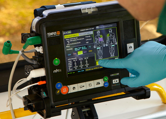
Amazon
Status date: 12 May 2017
The objective of this project is the development and validation of a tele-assistance service, using multiple space assets, for professional clinical users in remote locations using a compact device for vital-sign monitoring and remote diagnosis. It is based on a previous ESA-backed project, which resulted in the deployment of a telemedicine system for commercial aviation applications (TEMPUS)
Intelligent sensor and satellite network (ISSN)
Status date: 02 December 2016
The project is a feasibility study in order to establish whether there are sufficient market opportunities, and the technological maturity for developing a flexible and reliable intelligent sensor network where satellites are among the nodes in the network (ISSN). ISSN has a number of potential application areas in connection with Offshore Oil & Gas exploration and production, environmental surveillance in general, safety, search and rescue, transportation etc.
LymeMAP
Status date: 02 December 2016
Lyme Borreliosis (LB) is a rapidly growing health problem in the Highlands of Scotland. This disease, carried by ticks, is difficult to prevent because there is little information available about the risk of disease, and how to reduce it. LymeMAP integrates data from the Scottish National Lyme Borreliosis Testing Laboratory and local doctors’ surgeries with environmental data from Earth Observation satellites, to produce interactive risk maps providing information on ticks, LB and disease hot spots. For the first time in the Highlands, visitors and the local population will have access to accurate information enabling them to reduce their risk of tick bites and LB, whilst still enjoying the countryside.

AIR-Portal
Status date: 02 November 2016
The economic and technical feasibility of AIR-Portal, an air quality dashboard for European cities, was shown in this study. The consortium developed in a demand driven development the requirements of three major European cities into a working proof of concept. With this proof of concept the technical feasibility was proven, furthermore a business case was developed proving the economic feasibility.

VGTropics
Status date: 22 April 2016
In many African countries, livestock farming is an important source of revenue that improves the quality of life and strengthens the development of the economy. Animal health not only has an impact on animal production and its economic consequences, but zoonoses may also have an important impact on public health. Real time surveillance and prompt actions are paramount in diminishing the impact of epizootics on livestock. For this reason, early detection and shortening the time between detection, reporting and providing measures to contain an outbreak is crucial.
VGTropics is the result of the “Predict” feasibility study which was successfully concluded in 2012.
T4MOD
Status date: 30 November 2015
T4MOD project aims at developing and validating a user-friendly Telemedicine system, through an interoperable IP overlay satellite network associated to an intelligent end-to-end communication service, capable to support different medical specialities. This solution, to be validated in a military environment, could be also extended for future exploitations in civilian field for organisations (for example national health systems) operating in underserved and/or geographically isolated areas, such as in case of natural disasters or humanitarian crises. The system can be instrumental to develop new medical protocols for a cooperative medical work of diagnosis and therapies. T4MOD involves as users the health Department of four Ministries of Defence: France, Germany, Italy and Spain.

iVOICE
Status date: 17 September 2015
This study evaluates improvements to existing voice analysis technology. It is coupled with high fidelity communications signal and GNSS data, aiming to detect situations of mental strain and fatigue in operators. With the aim of offering a new technology – iVOICE, integrated VOIce analysis via satellite Communications Embedded in time and safety-critical environment. It also investigates the potential to develop services linked to high-risk and high-stress environments or dislocated domains, including heavy equipment operation, ground and air transportation for private and commercial use, as well as applications for future use in distributed health care for remotely living populations and peace-keeping communication and navigation services.
CyMonS FS
Status date: 02 February 2015
The consortium, led by surface water quality specialist BlueLeg Monitor (BLM) from Sneek, the Netherlands, has executed a contract with the European Space Agency (ESA) under the Integrated Application Promotion (IAP) program to develop services for the monitoring of blue green algae or cyanobacteria under the project acronym CyMonS: cyanobacteria monitoring services.
eHSA, Study on Sustainability, Liability & Business Aspects
Status date: 29 January 2015
Sub-Saharan Africa, characterized by its extensive rural populations with little or no access to conventional healthcare, renders eHealth a potentially effective solution for the provision of healthcare. The goal of the eHealth for Sub-Saharan Africa (eHSA) programme is the development of pan-African eHealth services, enabled by satellite telecommunications, to expand healthcare access for rural African populations.
ISAES
Status date: 01 December 2014
The proposed project is to conduct a feasibility study focused mainly on interoperability aspects derived from to design, implement and operate a pan-African eHealth platform based on a satellite communications system.

Mercury
Status date: 21 October 2014
Project Mercury aims to establish and prove the commercial viability of a new satellite based communications service that will end the isolation of Mobile Breast Screening Units deployed across the UK as part of the National Health Services (NHS) breast cancer prevention and detection programme.
PREDICT
Status date: 10 April 2014
The objective of the PREDICT (Prevent and Respond to Epidemics and Demonstrate Information and Communication Technologies) feasibility study was to define sustainable new services for animal health surveillance and early warning. The combination of Earth Observation and state-of-the-art Information and Communication Technology enables to improve early reporting and rapid response and contributes to limit the spread of epidemics.
ASSIST
Status date: 26 March 2013
Healthcare is facing increasing quality and resource challenges, which telemedicine services hope to solve. But will this make healthcare more efficient or safe? Can satellite communications add value to such services? A newly launched study - ASSIST - will aim to answer these and other questions.

eHSA Regulatory
Status date: 20 February 2013
Partnering with Africa to help strengthen health service delivery is a key driver of this project. The goal of the eHSA programme is to develop pan-African eHealth services enabled by satellite to benefit the sub-Saharan Africa (SSA) region. These services focus on providing various types of eHealth services to benefit citizens and health workers.
VECMAP Feasibility Study
Status date: 30 July 2012
Hitchhiking on international trade and travel, foreign species that act as vectors of disease (e.g. mosquitoes, ticks) may establish themselves in new environments world-wide if conditions are favourable. VECMAP aims at assessing the feasibility of developing a tool and associated service for automated mosquito mapping and forecasting.
Gulliver
Status date: 03 July 2012
The GULLIVER feasibility study aims at assessing the added value of space assets in securing the delivery of pharmaceutical goods. For that purpose, Novacom Services has fostered the creation of a wide community of experienced users covering the end-to-end distribution chain.
eHSA Governance
Status date: 25 May 2012
The governance study is the first in a series of four horizontal studies performed in the eHSA programme. The goal of the overall eHSA programme is to develop pan-African eHealth services, enabled by satellite, to benefit the sub-Saharan Africa region. The governance study will examine the basic conditions for implementing eHealth and telemedicine services in sub-Saharan Africa, whether imposed by the governments or by private parties.
TESHEALTH
Status date: 31 March 2012
The TESHEALTH project is dedicated to developing, implementing, qualifying and validating a telemedicine system promoting the use of satellite communications aimed at reducing the impacts of chronic diseases, improving life styles and empowering citizens to adopt a healthier behaviour.