
Objectives of the service
In this feasibility study, Maritime Robotics AS and EOMAP GmbH & Co. KG develop a system that allows a more efficient and accurate solution to survey bathymetry (water depth), seafloor properties, and seafloor habitats, as well as to monitor algal blooms in the water column. SyriUS investigates three innovative services that target the applications of maritime surveillance, environmental monitoring and offshore engineering. This is done by combining expertise in unmanned marine systems (UMS) and earth observations (EO) to create a synergetic value adding chain, which has the technological and economic potential to create a significant improvement of user’s current workflow.
Users and their needs
The SyriUS user communities include: hydrographic offices, navies, offshore industries, port authorities, dredging and marine engineering firms, land and marine-based mapping institutes, environmental agencies, policy makers, marine nature management, fishers, aquaculture industries, fresh water reservoir management, and scientists.
The end users involved in this study include hydrographic offices, local authorities for environmental monitoring, national agencies for geological mapping, institutes involved in environmental monitoring and mapping, and research institutes.
Their needs are broadly summarized with respect to three data products; bathymetric maps, benthic maps and habitat maps, as well as algae concentration and algae type-identified maps.
Within SyriUS, 28 user needs were identified, related to:
- spatial needs: high resolution mapping
- temporal needs: low production times and ability to repeat surveys
- high accuracy and low uncertainty on data products
- ability to discriminate vegetation from sediment, detect different vegetation
- ability to detect different kinds of algae
- ability to store data locally, synchronize with servers when possible, and ability for end users to interface to data servers
- seamless data models
Countries of currently involved end users: Norway, Germany, Sweden
Service/ system concept
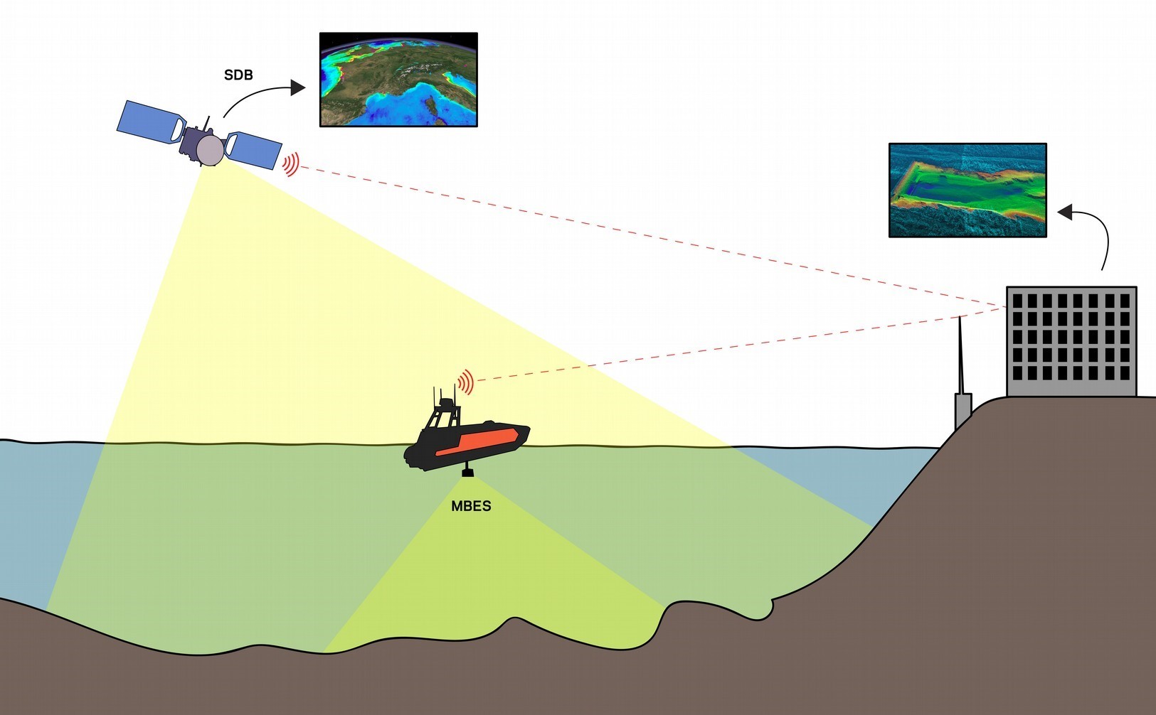
SyriUS combines data from UMS with EO derived data products. By doing so, we obtain the large area coverage that EO observations provide, with an accuracy closer to what UMS can provide.
For the three services provided by SyriUS, UMS systems will be used that have low draft, can operate in shallow waters, around obstacles, and that carry sensors customizable to the application: a multi-beam sonar sensor for bathymetric and benthic mapping, and water quality monitoring sensors or potentially underwater hyperspectral imagers for algal bloom monitoring. The Sentinel-2 and WorldView satellites provide data at the spatial and temporal resolutions to match the end users’ requirements. The systems will communicate through land-based and satellite-based communication frameworks, such that a single data product is delivered to the end user. Once the systems are deployed and services are in place, the end user may obtain data products over larger areas than currently possible, in a timely manner.
Space Added Value
The SyriUS project utilizes earth observation (EO) data, for example from the Sentinel-2 satellites, for their proposed services. The EO data provide larger area coverage than can be obtained from unmanned maritime systems (UMS). UMS data can however be used to calibrate and validate the EO data. In doing so, we create data products such as bathymetric maps for larger areas and at higher resolution than can otherwise be obtained. Without the space assets, it is not possible to provide a cost- and time-effective solution for mapping large areas for any of the application areas, e.g. bathymetric mapping for hydrographic offices.
Current Status
The SyriUS project is currently running a Feasibility Study. The consortium has interviewed potential end users for their needs and to identify current satisfaction, potential benefits, and expectations. The next steps are to create a System and Service Definition, as well as to continue assessing economic and non-economic viability. The Feasibility Study runs from April 2019 until December 2019.