
Objectives of the service
The key objectives of the project are as follows:
- Geophysical Survey (GS) and Pipeline Monitoring (PM) services, using remotely piloted aircraft (RPA) flying beyond line of sight, are targeted at the following End Users:
- The oil and gas exploration and production companies such as the Shell Group
- The mining exploration companies, such as Anglo American and BHP Billington
- We propose the introduction of a disruptive technology based on the use of light (<45 kg) RPA using satellite communications and navigation services to enable the RPA to operate beyond line of sight, and yet remain in contact with the Ground Control Station (GCS). The periodic introduction of innovations will enable year – on – year GS and PM service price reductions.
- The demonstration concept involves the use of a RPAS in a GS demonstration in the UK, so the data quality, the logistical requirements, the regulatory burden and all of the costs can be compared with equivalent metrics for manned aircraft performing the same task.
- The aim of the PM tests, to take place in Norway, and PM demo, to take place in Barcelona in Spain, is to evaluate the effectiveness of detecting anomalies on a road, during both day and night time.
- It is clear that potential customers want to see the data we plan to get from this User driven Demonstration Project. We need evidence to back the benefits to be gained through the use of a satellite communications + GNSS enabled RPAS based service.
Users and their needs
The End Users in this Demonstration Project are the large oil, gas and mineral exploration and production ("E&P") companies.
Royal Dutch Shell is involved in this Demonstration project as a User.
Shell GS-P&T (Shell Global Solutions - Projects and Technology Upstream) oversee the oil and gas exploration and production activities for Royal Dutch Shell. Shell GS-P&T provides technical services, technology capability and major project delivery in both Upstream and Downstream activities. Its activities include subsurface expertise and deployment, under which Geomatics falls. The Geomatics Department focuses on remote sensing, cartography, GIS services and geodetic integrity.
Oil and gas and mineral exploration and production companies view geophysical surveying as the identification of places on Earth to explore from consideration of present resource locations, a history of the Earth and any other insight they might have. Since the drilling for natural resources is an expensive activity, the exploration companies will want as much overlapping information as possible to reduce the possibility of drilling a dry well, for example. Consequently, the exploration companies will often perform a combination of airborne survey and surface based seismic survey.
Oil and gas production includes the development and subsequent monitoring of the pipelines and related installations, such as oil rigs at sea, refineries, pumping stations and terminals. Oil and gas pipelines that require monitoring extend for hundreds of kilometres, often in difficult terrains, such as the swampy marshlands in the Niger basin, the hot deserts in North Africa and the frozen areas in North Russia and the Arctic region.
As of today, GS missions are typically done using smaller manned aircraft equipped with various kinds of sensors, whereas pipeline monitoring is often done using helicopters, cars and people on foot. In both cases, users have a need for safer and less expensive operations, maintaining data accuracy. By being able to fly closer to the ground, one could expect an improvement in the resolution of the survey data. For pipeline monitoring, the ability to fly a RPA at night, with night-vision cameras, is important for situations related to security.
Worldwide
Service/ system concept

The intended solution is based on the use of broadband satellite based data relay and precision satellite based navigation to enable a small RPA to execute routine, precision, very low level flight Beyond-Line-Of-Sight, while performing geophysical surveys and oil and gas pipeline and related installation monitoring.
The RPA Pilot-in-Command and the Co-Pilot will be located at the GCS, and will have access to the unmanned aircraft via the broadband satellite data relay service.
In the case of oil, gas and mineral GS work, the RPA will relay telemetry data to the GCS, and the uplink, via the satellite, will consist of Flight Commands, such as, Return to Home in the event of a flight termination.
In the case of routine monitoring oil and gas pipelines, AnsuR will implement advanced software solutions for high resolution photo and video transfer, based on technology developed in the ESA project BEATLES, allowing users and viewers to request details of interest in real-time or near real-time in full optical resolution even over low bandwidth systems. The ability to use suitable little satellite capacity is a key driver for the business case due to the cost of L-band data.
The RPA will be fitted with automatic fly away prevention and recovery to a safe landing site in the event of system failures.
Expected Main Benefits:
- around 50% reduction in operational costs associated with the airborne platform
- higher resolution (higher relative values for high spatial frequency 2D Fourier coefficients) and higher quality geomagnetic survey data by using computer controlled low level ("tight drape") flight coupled with precision navigation based on Global Navigation Satellite System
- introduce an ability to operate in regions where it might be irresponsible to use pilots, such as over the Arctic ocean, or monitoring pipelines in areas of civil unrest
- contribution to reinforcing a positive public and commercial image of the End User being a dynamic organisation at the forefront of new technology that has real benefits more environmentally sound / friendly / responsible technology.
Space Added Value
Using reliable broadband satellite communication for command and control of the RPA together with precision satellite navigation, RPAS can be operated over a large area without the need for a terrestrial communication network with coverage in the whole operational area, or ground based navigation systems. This increases the operational flexibility considerably and has the potential to reduce the cost of the operations.
For monitoring services, the ability to access the payload data in near real-time can increase awareness and reduce response time considerably.
Together RPAS and space assets enable a wide range of services.
Current Status
The project is completed
Project Kick-Off was on1 February 2013. The project was completed on 18 June 2015.
Main Achievements
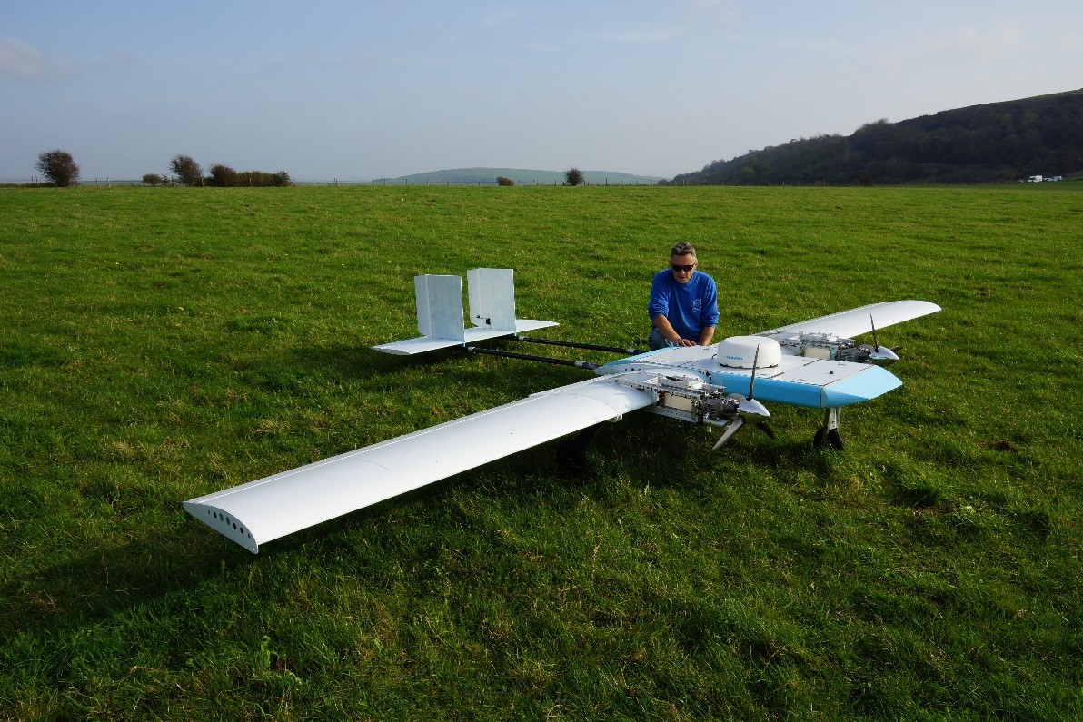
- Extended the capability of our existing Inview Remotely Piloted Aircraft to enable it to carry a heavier payload, including a Ka band satellite data relay terminal, in addition to the L-Band satellite data relay terminal used for command and control purposes.
- Developed and demonstrated an adaptive communications configuration based on the use of a combination of a wireless Ethernet bridge link, a Satcoms link using the Inmarsat SwiftBroadband network and a backup satellite link using the iridium short burst data service.
- Following extensive documentation, flight testing and interaction with the regulatory authorities, we established the regulatory basis for operations involving the use of remotely piloted aircraft in the national airspace in the UK and in Norway.
- After significant investment of time and effort in the processing of the data from the magnetic sensor, we demonstrated the use of Remotely Piloted Aircraft in geophysical survey applications, with the quality of the data match that obtained from manned aircraft.
- Based on our work with several satellite data terminals, and the modular construction of the Inview remotely piloted aircraft, we have demonstrated the use of several types of satellite data terminal in oil pipeline monitoring activities.
- Geophysical Survey tests and demonstrations were conducted in the UK
- Pipeline Monitoring tests carried out in the UK and in Norway, and demonstrations were performed in Norway
Conclusions
- We now have an excellent, mid-sized, remotely piloted aircraft that can be used in more applications than we had originally envisaged, opening up opportunities that we had not considered at the start of this project.
- Interestingly, although satisfying the regulatory requirements required a significant amount of paperwork, we have been helped in this activity by the positive approach adopted by the staff in the national regulatory agencies, such as the UK Civil Aviation Authority and the Norwegian Civil Aviation Authority.
- We were surprised by the amount of work we had to do on the magnetic sensor itself and on the sensor data processing software in order to achieve high quality data that match the data obtained through the use of manned aircraft.
- The next steps to obtain certification for the Inview RPA from the UK civil aviation authority, and then start pilot geophysical survey and oil pipeline monitoring activities using the Inview RPA in segregated airspace.
Prime Contractor(s)
Subcontractor(s)