Objectives of the service
Considerable effort has been invested all over the world to conduct traditional ship and aircraft-based surveys for mobile and wide-ranging whales. However, these are costly and can only cover a limited amount of seascape.
In the open ocean, individual whales are challenging to survey due to limited range of aerial or ship surveys. Most whales range from 15 – 25m in length, making them ideal for detection from very high resolution (VHR) satellite imagery (e.g., a 15m long whale will be ~48 pixels long on a 31cm VHR image if fully surfaced). This means that specific body features can be detected (e.g., the fluke or colouration) for identification to species level. Previous work has demonstrated the feasibility of identifying large whale species from VHR satellite imagery.
The SPACEWHALE service is a tool to semi-automatically detect large whales from VHR satellite imagery. This has the ability to improve and extend existing surveying regimes and can serve conservation purposes well beyond monitoring alone.
Users and their needs
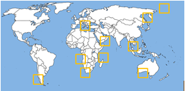
The SPACEWHALE service can benefit globally distributed non-governmental organisations, academic and government institutions, and private companies (e.g., oil and gas or tour operators) who are engaged in global studies or monitoring efforts on large whales, particularly in open ocean environments that are inaccessible to traditional survey methods. These users generally require:
- Robust stock assessments in remote offshore areas
- Data on distribution and abundance for baseline studies
- Data in areas where surveys are often cancelled due to poor weather (e.g., polar regions)
- Surveys which complement ship and aerial surveys to increase survey area
- Surveys of poorly known breeding areas
- Any information possible on species that are lacking occurrence or abundance records
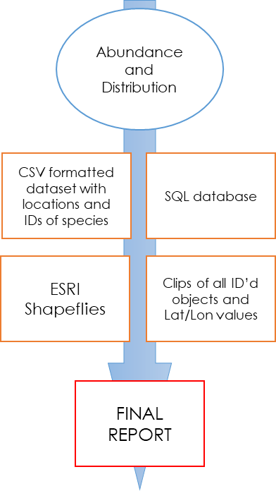
Typically, end users will require a final report detailing abundance and distribution of identified species, as well as:
- ESRI compatible shapefiles of locations of whales
- Clipped images of whales identified in the imagery
- CSV formatted data sheets with Latitude and Longitudes of each identified whale
and/or
- An SQL formatted database of outputs that can be easily queried
Service/ system concept
SPACEWHALE offers a service that forms a bridge between space asset providers and stakeholders in need of population assessments of large whales in predetermined areas of interest.

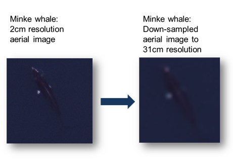
The SPACEWHALE algorithm is based on deep-learning techniques using convolutional neural networks (CNNs) which are widely used in other applications e.g. facial or vocal recognition software. The algorithm is trained using a large dataset of high resolution digital aerial imagery from aircraft-based surveys. We used 2cm resolution aerial images of minke whales, down-sampled to 31cm resolution to match WorldView 3 satellite imagery.
Once we receive the user-defined area, we work with satellite imagery providers to obtain appropriate imagery. The CNN is run against that imagery via the following basic workflow:

Note that as more objects are identified, they are used for re-training the algorithm so that it becomes better at finding whales over time.
The final report showing abundance and distribution is generated after the CNN-detected objects are examined and ID’d by our expert team of reviewers. Latitude and longitude values are noted for positively identified whales and ESRI shapefiles, CSV formatted data sheets and SQL databases can be generated from this for user ingestion.
Space Added Value
The SPACEWHALE program not only makes use of the latest in analytical techniques (deep learning), but also takes advantage of the latest in satellite imaging technologies. It leverages data from the Worldview-3 sensor from Digital Globe (Digital Globe, Westminster, Colorado), which provides VHR satellite imagery with a ground sample distance of 9.4 pixels per m2 for a 31cm panchromatic resolution. This resolution has been shown by the SPACEWHALE algorithm and previous work by others to be acceptable for identifying large whales in the open ocean.
This usage of satellite technology has the ability to greatly increase the total global ocean surface area surveyed for large whales. This means that we improve our knowledge of the distribution and abundance of charismatic and ecologically important whales. Moreover, it allows us to bypass the risks of ship or aerial-based surveys which can be delayed or cancelled due to weather.
Currently, SPACEWHALE is the first commercial service of its kind, and competes only with existing aerial or ship-based survey methods. It is likely to become cheaper and more efficient than these methods as satellite technology progresses and is currently on par with (in some cases cheaper than) costs for traditional surveys.
Current Status
The SPACEWHALE kick start project was launched in April 2018 and was successfully completed in December 2018. The SPACEWHALE algorithm accurately detected whales in satellite imagery independent of training images, thus proving the concept and technical feasibility. SPACEWHALE was able to achieve 100% accuracy on the identification of large whales in test imagery for this kick-start activity. Furthermore, SPACEWHALE has shown that the combination of satellite technology, the latest deep learning methods, a well-developed training dataset and experienced reviewers will be a cost-effective way to get information on the distribution and abundance of large whales. The program can now be applied to new areas via a follow-up demonstration project.
Prime Contractor(s)

Subcontractor(s)