
Objectives of the service

Epic Blue offers a field team tactical awareness solution called Guardian. It consists of a web-based platform and apps for smart devices.
The SenTAct project built on top of Guardian to help teams in the field working in hazardous environments have access to critical information relevant for the local context. The service leveraged Epic Blue Location Intelligence to provide the right information at the right time and focused on the ease of access and understanding of the information.
The typical customer of the solution needed to stay in close contact with teams in the field. The increase in a shared understanding between the various teams and with the operation centres was achieved through an intuitive access of information. It enabled the coordination of emergency responses. This enhanced coordination relies on real-time geo-referenced assets and people management for field tracking.
The technology of SenTAct allows to:
-
seamlessly locate staff and assets both outdoors and indoors.
-
sense if the field staff falls, stops moving abruptly, crosses 4D geo-fences, or reaches maximum exposure times to certain operational environments.
-
provide mission intelligence, such as maps, imagery, customer site plans, mission graphics and points of interest.
-
facilitate staff interactions by geo-tagged messaging via text, voice or images that contain annotations to increase local awareness.
Users and their needs
SenTAct targeted 1st responders, staff in industry and private security. Users often refered to SenTAct as the WhatsApp for our mission critical awareness.
It was used by two types of users:
-
Operation managers coordinating the field teams (in dispatch centres or control rooms). The Operation managers can quickly get an overview of the situation by receiving the most recent and relevant information, and rapidly take the decisions and communicate these that best suit the current situation. Looking at historical data, managers & commanders can execute risk analysis tasks using the proposed solution.
-
Field teams, who will rely on mobile apps which are part of the solution. Through the location of the teams, context-aware information can be provided either manually or triggered automatically by the service. The context-aware aspect is essential in order to provide the right information combining the field staff’s perspective and the organisation’s imperative.
The customers were located throughout the EU and MENA.
Service/ system concept
SenTAct was built on our existing Guardian product. It offers continuous awareness of the location of key resources irrespective of the environment in which they operate. Knowing the outdoors and indoors location of teams in real-time and being able to collect the location over time for further analysis was of critical importance.
To support operations, multiple data themes were included: Vehicles locations, team member location and status, biometrics, building CAD drawing integration, building occupancy, CCTV feed, Drone feeds, Streetview-like, Cadastre, Street maps, Weather, IoT Sensors.
The field team tactical awareness service made this information available in the field in a highly automated manner, with minimal intervention of the teams in the field. As a complementary stream SenTAct foresaw a text-based messaging stream. Having an own version of Whatsapp was seen as highly relevant.
The user facing capabilities made the information easy to manage and digest in the field. They included: Mission Management, Mission Rule Agents, Proximity to hazards, Shared Map Annotations, Custom Grid Overlays, Search Coordination High Likelihood Areas, Mission pattern analysis, Mixed Reality overlays.
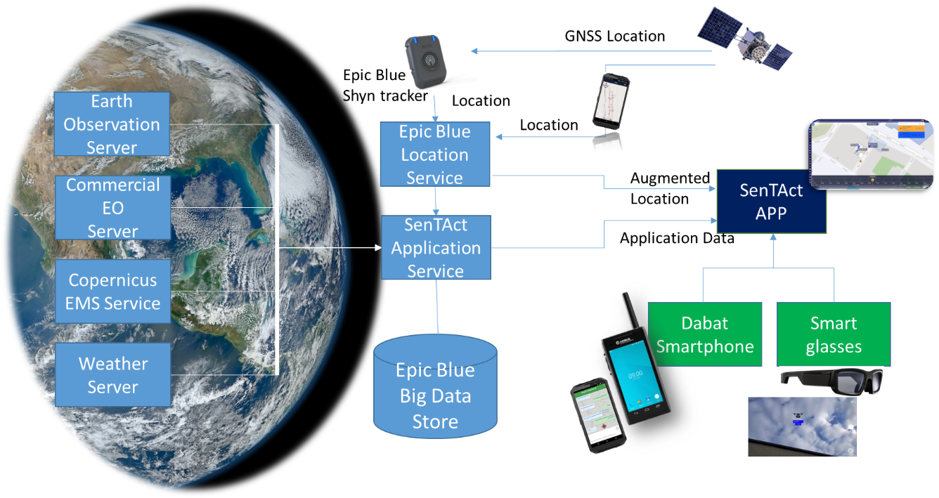
The SenTAct Application Service incorporated a range of Earth Observation data and it plugged in the Epic Blue seamless location service to augment the location data of teams in the field. The Application Service managed all operational data and stored collected information into the Epic Blue Big Data store for reporting and future trainings. Users could access the capabilities through a browser-based app for operational managers and a smartphone for the field teams. Moreover as future capability demonstration SenTAct functionality was demonstrated as App in smart glasses.
Space Added Value
Navigation (Galileo): in view of the solution having access to highly accurate and reliable positioning was critically important. The more accurate the position, the more relevant data could be provided to the field teams.
Weather: Weather data in the context of this service was used to look for patterns in operational execution (i.e. if the wind is like that and it rains, then….).
EO: Visual products were used as contextual backdrop and building feature extraction. The building feature extraction was highly relevant to (1) know whether people are in the open or inside (2) enable rapid geo-positioning of building blue prints (3) discover hidden structures which were not mapped out previously.
Current Status
The SenTAct project was a major success. Epic Blue and its partners met the objectives of providing a validated capability oriented to the safety and security of 1st responders and industry workers.
The project and the resulting field team tactical awareness service had several objectives. These objectives can be categorized into three main groups:
-
Seamless Location Awareness
-
Information in the Field
-
Shared Awareness
The Pilot provided Epic Blue with an opportunity to validate the SenTAct solution as a key closing point of the whole project. We could validate SenTAct from an operational and technical perspective. Customers have signed already to rely on the service for the safety and field awareness of their teams.