Objectives of the service
The objective of the Saltwater project is the establishment of a sustainable service for monitoring and alerting of water quality anomalies for aquaculture.
The demonstration study aims at developing and demonstrating services to the market place for surface water quality monitoring. The service combines the data interpretation of satellite imaging and local field monitoring.
Satellite imagery can provide more information for aquaculture companies about the water quality, such as incoming phytoplankton blooms which can cause damage to the fish stocks. The current practices involve water sampling in remote and harsh locations after which the samples have to be analysed under a microscope to determine the phytoplankton density and composition. This is time consuming activity and requires specific knowledge of the employees doing the microscopical analysis.
The Saltwater service also provide two types of in situ monitoring instruments. These instruments are based on the same type of sensors used in satellites, which make them highly complementary. The in situ measurements are used to develop and validate the algorithms for detecting phytoplankton. These sophisticated algorithms are applied to historical and recent satellite imagery.
The data is provided through a web portal which displays satellite imagery as maps and in situ measurements as time series.
Users and their needs
The targeted users are employees at aquaculture companies who are responsible for the feeding, production and environmental monitoring on both the operational and strategic level.
The user needs are:
- Information on the location, occurrence, identification and distribution of harmful phytoplankton species.
- To gain a greater understanding of the water system characteristics, in particular factors that contribute to the occurrence of phytoplankton blooms, such as water temperature.
- Ability to analyze environmental data from several sources in several data types.
Within this demonstration study, Marine Harvest Canada, a large salmon producer based among others on Vancouver Island, Canada, and Plancton Andino, Chilean an environmental monitoring company that analyzes samples for aquaculture companies in Chili, are the users.
Service/ system concept
The users receive the following data products
- Chlorophyll maps in near real time. Retrieval algorithms are fine-tuned using in situ measurements in order to achieve highest possible accuracy
- Maps displaying concentration or indicator of presence of harmful phytoplankton species.
- Water temperature maps
- High frequent time series (every 10 minutes) of chlorophyll content and phytoplankton species content on a fixed, strategical location. The data is provided by the Ecowatch and is available in real-time.
- Concentrations of chlorophyll and phytoplankton on multiple locations using the WISP-3, the in situ instrument.
The global architecture is as following.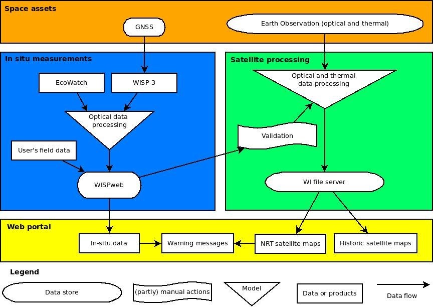
Space Added Value
Imagery from Sentinel-2, Sentinel-3, VIIRS and MODIS are used to produce relevant data products for the users. Historical archives are used to create maps displaying locations with a higher risk of the occurrence of HABs (Harmful Algal Blooms).
The in situ instrument uses GNSS to store the geographical coordinates at which the measurements were taken.
The data products are provided in near-real time via a web based portal. To complement the service users are instructed in the use of the WISP-3, a handheld optical device allowing them to inspect water quality locally and to determine more in detail the cause of the water quality anomaly This makes it possible to use the satellite images on a daily basis on the aquaculture farms. The farm management takes decisions on whether or not to feed and switch on air pumps to increase oxygen contents in the water, depending on the presence of harmful algae.
The service is unique, since the consortium has access to in situ reflectance measurements, satellite imagery and datasets from the users, making it possible to create high quality, accurate data products.
Competitors typically do not have combined access to these data, or only for a limited area.
Current Status
The overall status of the project is as following:
- Retrieval algorithms for several specific phytoplankton species have been developed
- Automatic processing chains for some satellites have been set up and are being set up for other satellites
New in situ measurements are being taken together with regular phytoplankton samples. These and historical datapairs are analysed to further develop and validate phytoplankton algorithms.
Prime Contractor(s)
Subcontractor(s)