
Objectives of the service
Mining exposes fresh rocks to the elements. In the presence of water, minerals react, creating acidic solutions. The acid dissolves toxic metals in the rocks and mobilises them into the environment, polluting water resources. This process, known as ‘acid mine drainage’, happens at active and closed mines globally, costing billions.
Mining is conditional upon an operator demonstrating that they control harmful emissions. Responsibility for cleaning-up pollution from long-abandoned mines usually rests with the State, with regional bodies governing many sites with limited resources. Climate Change will drive new environmental impacts from active and legacy mine sites, increasing the burden.
The world faces huge water shortage and security challenges, but an ever-increasing demand for essential minerals. It is imperative to improve water and environmental management practices.
The RiPolMin remote detection tool will be a web-hosted platform, with user-friendly download options. It aims to rapidly locate areas of concern across a mined region and then allow heavy metal pollution to be tracked at a local level. The two scales can serve as an early warning system and a guide to where thresholds have been exceeded. The combined tool is designed to enable targeted monitoring, proactive and better-informed management of river catchments.
Users and their needs
Acid mine drainage pollution occurs on every continent.
Conventional environmental monitoring and land management needs ‘boots on the ground’. For active mines, it requires regular survey and sampling of specific points on a river to ensure compliance. For abandoned mines, it is often after an incident.
Hands-on monitoring is resource intensive and time-consuming and needs laboratory analyses. It rarely benefits the wider river catchment, or its users, or provides opportunity to proactively prevent pollution and liabilities.
The uptake of RiPolMin would come from local, national and international users:
- Government bodies/regulators
- Water authorities
- Mine operators
- Landowners and developers
- Conservation and aid organisations
- Local population
- Water-dependant businesses
Service/ system concept
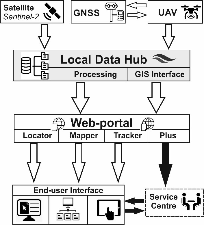
RiPolMin will combine terrestrial, satellite and aerial (UAV) data in a user-friendly GIS platform. It is designed to be accessed via a web-based portal, from which the user can order and access data packages for an area or interest.
Planned data packages include:
- AMD Locator – Sentinel-2 screening tool to locate problem areas at regional scale
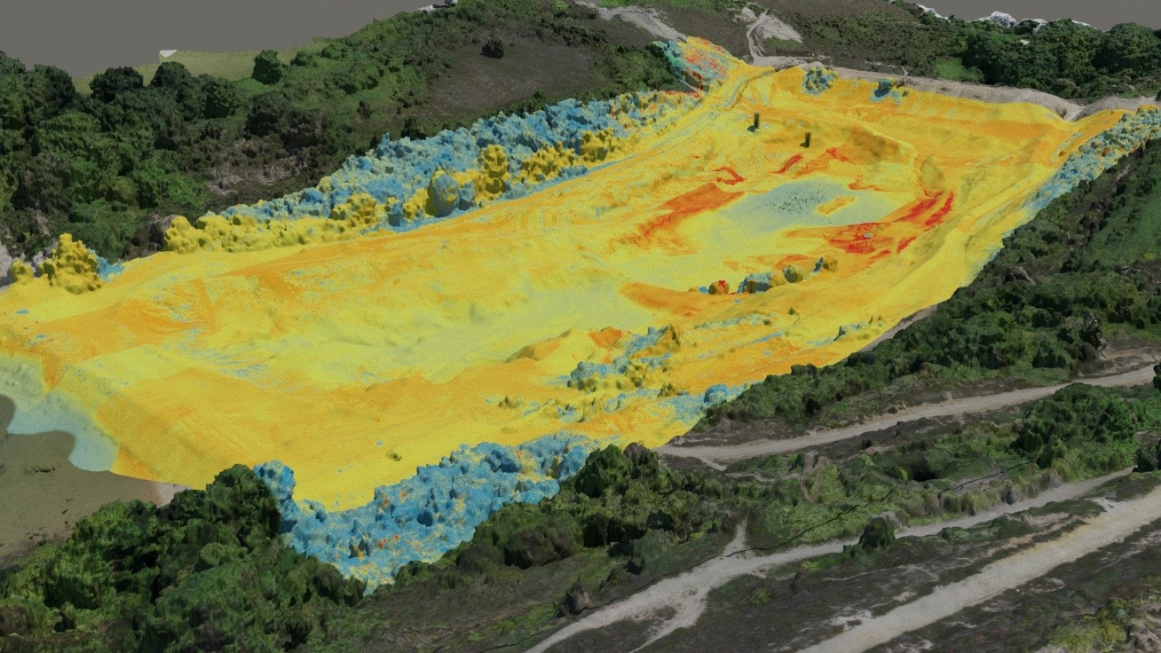
- AMD Mapper – Drone-borne spectral maps of site-scale heavy metal pollution
- AMD Tracker – Combined data indicating hazard zones where regulatory thresholds may have been exceeded
- AMD Plus - Complementary environmental monitoring consultancy service.
Data interrogation tools will allow measurements and the design of sampling points and field survey parameters.
Beyond a viewing platform, there will be options to create and download PDF maps or export GIS-ready data, for use at a monitoring station or on a field device.
Future development could include a field App tailored to specific end-user requirements and existing procedures.
Space Added Value
The spectral bands of Sentinel-2 are suited to agricultural and land management uses. RiPolMin uses mining expertise and Sentinel-2 data to expand this and identify acid mine drainage. This is done by using spectral band ratios that emphasise this type of pollution. The added value comes from a technique developed for Cornish sites, to remove non-mining spectral responses. This allows basic but affordable evaluation of large, or inaccessible areas.
The weekly Sentinel-2 flyovers provide opportunity for regular monitoring. This is valuable in giving confidence for the deployment of drone-borne spectral surveys of target sites.
Ground truth data has added value to the interpretation and mapping of certain metal-rich soils from the drone-borne hyperspectral surveys, allowing a targeted ground campaign to be designed and implemented using a GNSS ‘stake-out’. A simple sensor has allowed correlation of potentially harmful levels of metal pollution, reducing the costs of other UAV spectral surveys on offer.
Current Status
The RiPolMin team has concluded a Kick-start. The activity had positive success in screening problem sites using Sentinel-2. Initial trials using code for open-source software tools have proved promising for cost-effective hyperspectral data processing. The spectral mapping of toxins from drone-borne data showed significant promise.
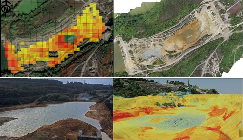
The results have been integrated with end-user and key data in a GIS, to demo the role of RiPolMin data on real sites.
Virtual workshops have been held with UK regulators and presentations given to landowners and industry. Feedback has been positive. Uptake of RiPolMin will depend on price-point and reliability.
The spectral mapping tool needs to be a dependable, consistent and cost-effective alternative to physical survey. Due to the complexity of mine sites, further testing is needed in a range of conditions to validate and hone the technique. Further evaluation of spectral mapping by easy-to-detect proxies and the potential application of machine learning to reduce data processing costs is required.