Objectives of the service
In order to prove and demonstrate the added value of using EO data in support to critical infra-structures, RESUCI offers two services to its users:
- Service 1 - Right of Way monitoring for obstacles and activity detection, using EO data for the recurrent mapping and monitoring of powerlines protection corridors and interest areas, to detect:
- Obstacles that need to be removed because represent a hazard for the Critical Infrastructures (CIs); and
- Human activity in the vicinity of the critical infrastructure.
- Service 2 - Field maintenance operations management and control, which uses EO data together with semi-automatic and visual inspections, to perform continuous verification of the field maintenance work and provide support to improve planning and prioritizing as well the estimation of the effort needed for the field maintenance work.
These services were developed in accordance with the needs and requirements of stakeholders representing distinct costumer segments:
- Energy network operators – these users typically manage different types of critical such as powerlines and gas pipelines. These two types of critical infrastructures are subject to various risks that can affect the arrival of both electricity and gas to all consumers.
- Right of Way managers – such as fire break networks, that include the firebreaks surrounding infrastructures, such as houses or urban-forest interfaces.
As an alternative or complementary solution, to the traditional assessment methodologies (helicopter, field inspection, etc), RESUCI addresses the technical and commercial added values of using earth observation services to manage, keep track of the potential risks and to help on the implementation of new CIs.
Users and their needs
RESUCI is oriented to address several needs:
- Land use categorization
- Detection of potential obstacles (man-made, natural) in the powerlines protection corridors;
- Detection of new human activity in the vicinity of protection corridors;
- Verification the work of the maintenance teams;
- Increase efficiency through improved planning and prioritizing of the field maintenance and inspections work;
- Estimation of the effort needed for the field maintenance; and
- Overview and detailed land use mapping in support to development of a new infrastructure or maintenance and inspections operations on existing infrastructure.
Service/ system concept
RESUCI provides layers of information to help users dealing with their recurrent needs:
- Percentage of area occupied by potential obstacles on protection corridors
- Detection and categorisation of potential obstacles on protection corridors
- Timespan analysis to study the evolution of the surroundings of critical infrastructures
- Identification of areas that were subject to maintenance operations
- Technical reports
Space Added Value
RESUCI uses EO and GNSS data to address the needs and requirements of its users. These types of data have big advantages when compared with traditional monitoring methods, namely:
- The ability to generate products in different spectral bands (electromagnetic radiation) in addition to the information that is visible, which makes it possible to study in detail certain chemical and physical properties of objects that are not understandable to the naked eye.
- The integrated view of space allow to understand relationship between the different components to be analysed and the surrounding landscape;
- The ability to obtain data at a distance, without the need to move teams on the ground, as well as to acquire such data on remote or inaccessible regions;
- The opportunity to work with satellite data at different scales allows a synoptic view of all the space of interest, to a detailed view of the objects of interest, compatible with the resolution of the sensor system used;
- The possibility of temporal analysis, through the repetitive coverage of a single point on the earth's surface by the successive passages of the satellite(s);
- Digital image processing allows the production and analysis of results in a fast and automated way, as well as its immediate integration with information systems, geographically and non-geographically based
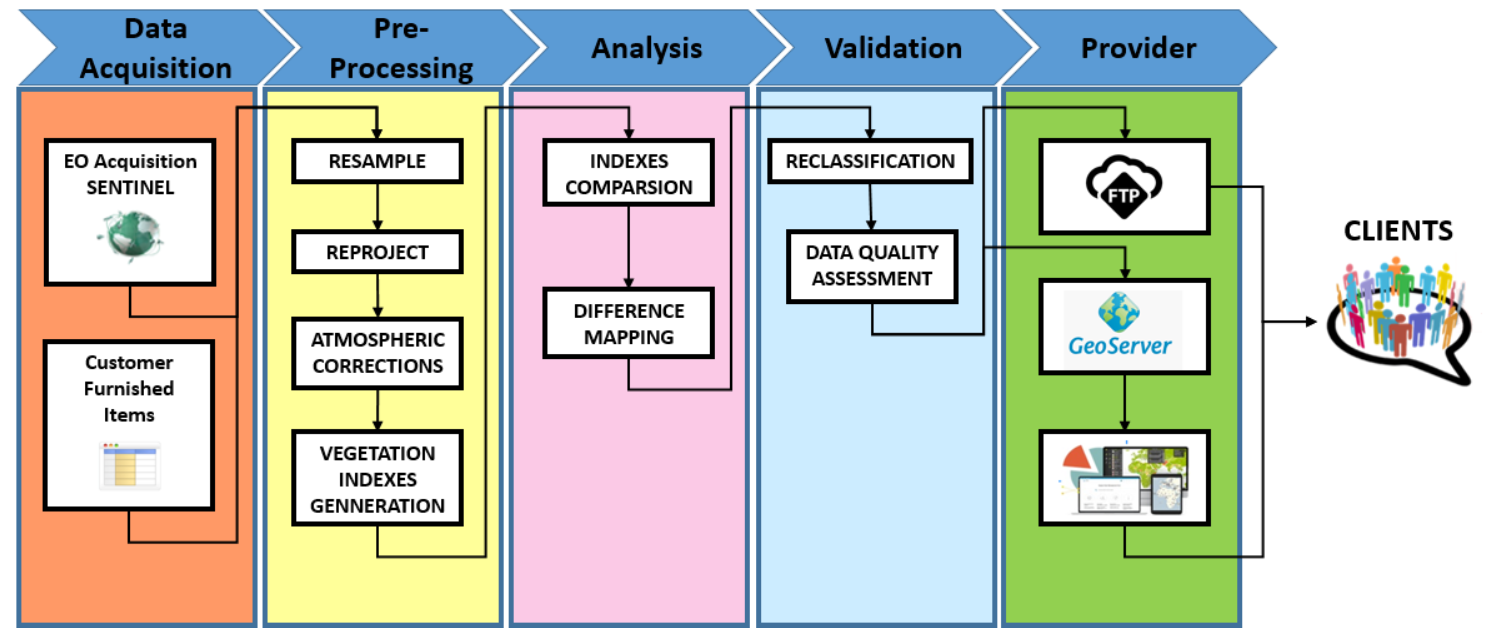
Current Status
RESUCI is already generating outputs in accordance with the services’ definitions:
Service 1 makes use of very high resolution images (spatial resolution of approximately 40cm) to perform vector data extraction on the right of way, making use GMV’s imagery analysis expertise and generate outputs as the one illustrated below:
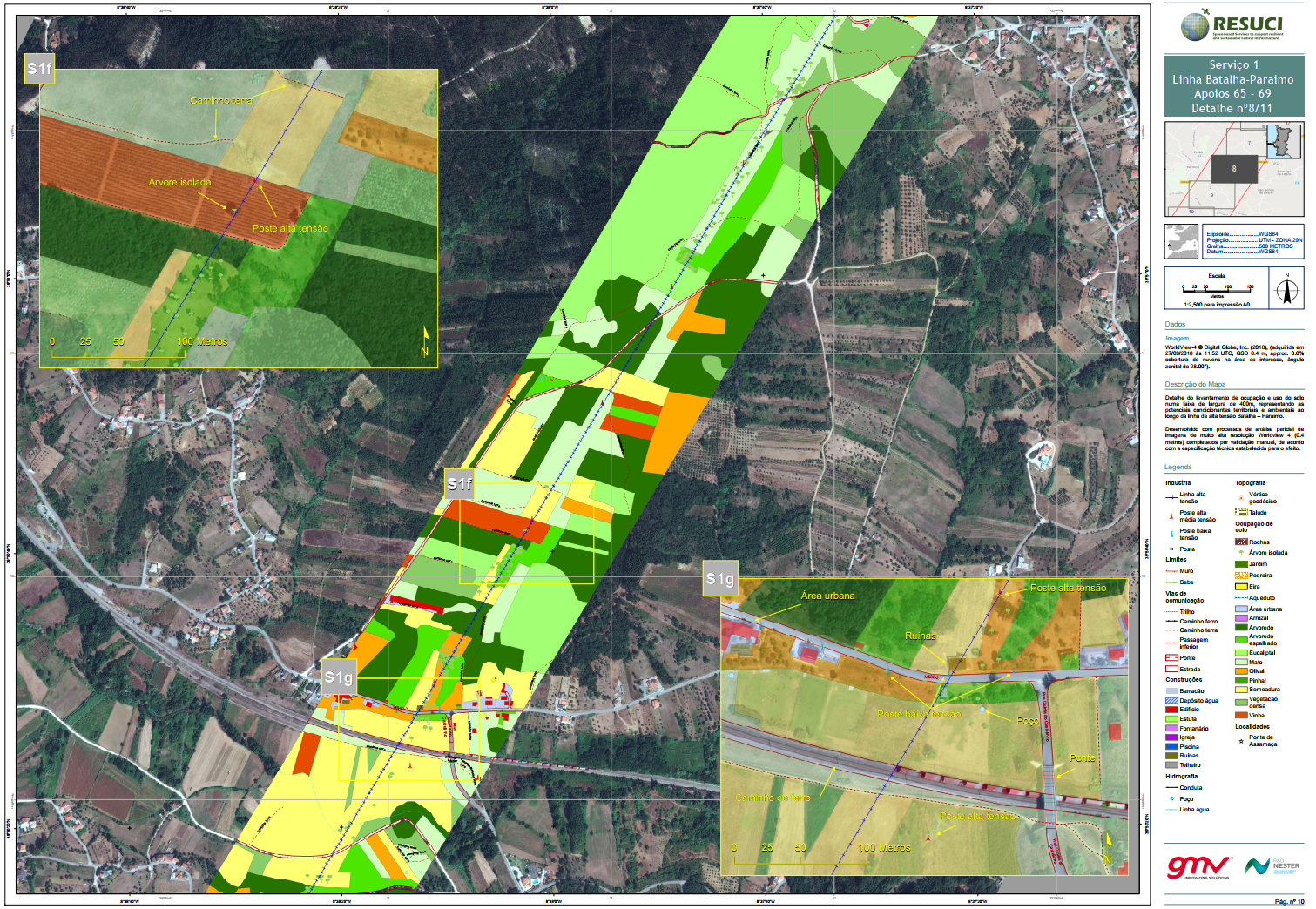
The recurrent generation of outputs for service 1 provides valuable information since it depicts the evolution of the surroundings of right of ways along time, allowing to map non-conformities that may exist.
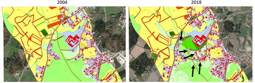
The figure below provides one example of such analysis showing the appearance of new man-made features inside a gas pipeline protection corridor.
Service 2 makes use of automatically ran procedures to repeatedly detect changes on land use and land cover along the RoWs (as illustrated in the figure below) based on vegetation indexes. The detection of changes is empowered by the use of image segmentation and spectral analysis procedures.
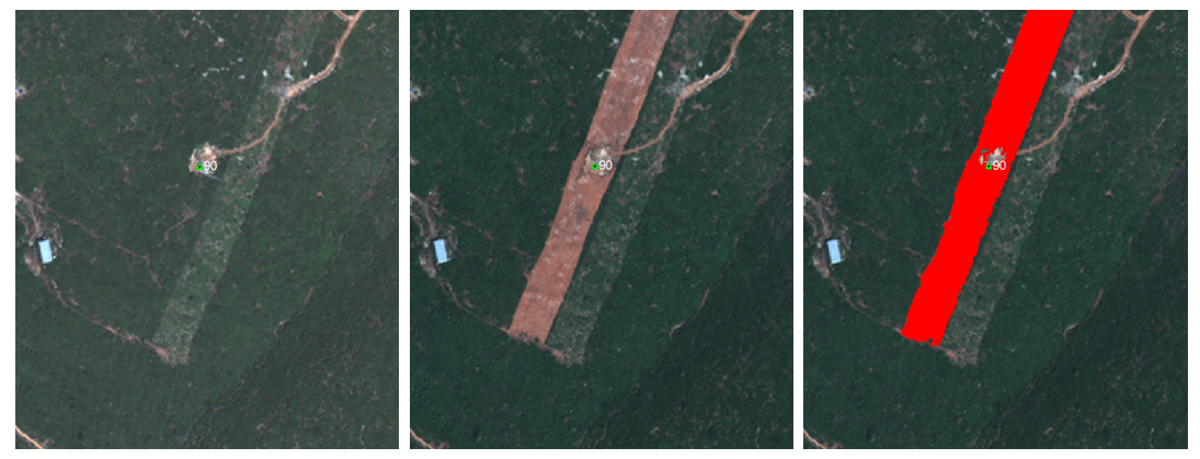
Service 2 runs permanently and automatically, providing the users with a powerful tool to help on the management of the RoWs.
The team that developed RESUCI is now preparing a proposal based on the findings and lessons learnt, to move towards a demonstration project in which the services that were already developed can be now fully operationalized in order to allow their commercialization.
Prime Contractor(s)

Subcontractor(s)