Objectives of the service
An online tool developed to visualize coastal erosion and accretion in Togo, Senegal and the Maldives. The tool is powered by Google Earth Engine platform and will provide information relevant to coastal zone management, institutions involved in financial planning of infrastructure projects, the tourism industry and entities involved in early warning and resilience.
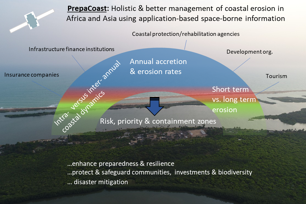
Human-induced sea level rises are threatening many coastal communities in developing countries. Coastal protection and development agencies that are implementing early response (i.e. evacuation) and long term resilience measures (i.e. construction of sea walls etc) need coherent information on coastal erosion risk and priority areas. Conservation entities require information on how coastal morphology changes are interlinked to marine animal habitats or their nesting sites and where restoration actions, such as mangrove reforestation, would be most effective in terms of mitigating erosion.
This service will help various stakeholders to better implement coastal protection and management schemes. This will be done by identifying where information needs and gaps can be filled by the information that can be self-extracted using the online tool. The tool goes beyond the state-of-art since not only coastal erosion localities for certain coastal sections and time periods are mapped but seamless monitoring of accretion and erosion rates and corresponding severity levels is facilitated. This includes the monitoring and interactive visualization of intra- annual coastal dynamics and particular vulnerable coastal stretches (i.e. erosion risk areas in close proximity to hospitals or tourism infrastructure).
Users and their needs
The following institutions are actively involved for the two geographical areas.
For the West African region:
- Agence Nationale de Gestion de l'Environnement (ANGE)
- Staff members from the project ‘D’investissement de résilience des zones côtières en Afrique de l’Ouest (WACA Togo)’
- Staff members of the project ‘multinational Benin/Togo de réhabilitation de la route Lomé – Cotonou (phase 2) et de protection côtière (corridor)’
- ‘Agence nationale de la protection civile’ in Togo
- The ‘Convention d’Abidjan’
- University of Lome, Togo
- Corporate affairs of the Port in Lome, Togo
For the Maldives;
- EPA- the Environmental Agency of the Ministry of the Environment
- The Olive Ridley Project as an NGO representing conservation action
- The Tourism industry as represented by the company Thoha Rasheed
The following main use cases can be identified for both regions;
- Reduce time and costs of field visitation efforts, often used to monitor coastal erosion on remote areas or islands.
- Augment existing or upcoming coastal management development plans (Togo/Benin)
- Identify local risk and priority areas of implementing coastal protection schemes
- Guide holistic conservation actions efforts, i.e. protecting/restoring turtle nesting sites that are particular vulnerable
Service/ system concept
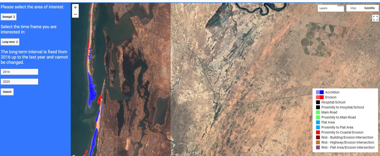
The concept was implemented as an online application using the Google Earth Engine platform and as such the architecture has a ‘back-end’ processing and a ‘front end’, accessible by the users (see image below). The users are only interacting with the ‘front end’ by entering the type of information that is required for their specific area of interest. As such, the user has the option to visualize intra- annual erosion/accretion severity (short term seasonal morphology changes) or inter-annual erosion/accretion over selected years that is the maximum period for which data is available (long term trends). Using the long term erosion trends, the users can specify if specific risk and priority zones should be identified. The service back-end will process the relevant satellite imagery for each information level and add users defined data on important features (such as hospitals, and particular vulnerable or densely populated communities) to visualize specific risk or priority zones (in the front end). The online application or tool can be set up as a subscription service. The information feeds and risk zones are computed and visualized for each year going forward.
Space Added Value
The use of Copernicus Sentinel-2 satellite data sets ensure that users have access to explicit, continuous and spatially coherent information on coastal morphology processes that pose a risk to communities and infrastructure and biodiversity. Coastal erosion and accretion surveys are conducted by EPA (Maldives) for individual islands using the main Island of Male as a starting point. However, these surveys are expensive since the islands are often remote, and, moreover, surveys are generally conducted as ‘once off’ activities using drones or fields surveys. This makes them less effective to assess spatially and temporally coherent trends in coastal erosion and accretion, as well which processes are rather seasonal, or less harmful, and which actually constitute harmful erosion.
In West Africa, knowledge is needed on the effect of port extensions on coastal erosion/accretion. Infrastructure finance institutions such as WACA will then use this knowledge to assess the financial trade-offs of a certain project or funding mechanism. Currently coastal change surveys in Togo and Senegal are rather localized while those surveys that use satellite imagery (spatial) do not separate fundamental erosion from short term changes or do not consider erosion/accretion severity trends.
Current Status
The study is now complete. A series of workshops with users in West African and the Maldives were organised. Discussions were held to ascertain use cases and share the results and the online tool itself.
The users’ feedback provided evidence as to the cost savings factor of the tool for users (in comparison to existing coastal surveying methods) and its relevance to existing and upcoming coastal management plans.
The below images provide a snapshot of some of the outputs from the online tool. The first image (A) shows that it is possible to monitor intra-annual changes, e,g for the year 2018 for a coastal stretch in Senegal. Figures B and C illustrate the outputs for annual long term Accretion and Erosion.
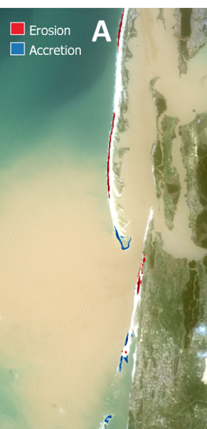
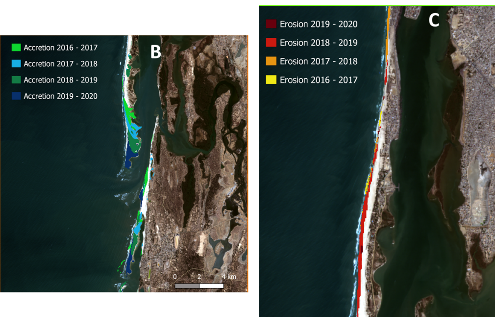
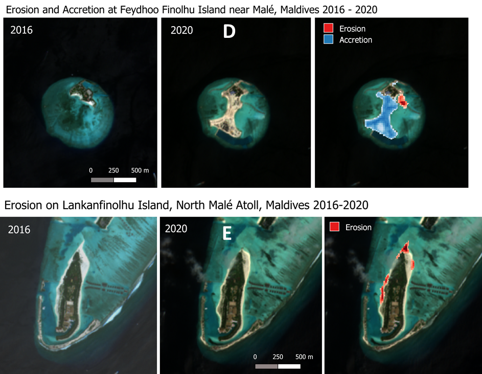
Figure D and E illustrate outputs (examples) for the Maldives.