Objectives of the service
The project has developed a set of Ground and structural motion monitoring services can utilise both space and terrestrial technologies and offer both wide area and site specific analysis. This allows target users at both the strategic level (e.g. Highways England and their large network of roads) and site level (e.g. Engineer responsible for particular sites) to obtain the information most pertinent to them. Product offerings include the following:
- InSAR Survey - Quick, affordable response service for any ground instability issue
- Cluster Analysis - Combines measurement points showing similar behaviours to give users a better understanding of different modes of ground motion
- Outlier Identification - using Cluster analysis to highlight those measured points that behave most unlike all other points within the same dataset.
- Baselining- Using Historical InSAR measurements to give users an idea of the behaviour of the ground prior to their activities
- Trend Analysis - Groups areas showing similar ground motion behaviour to enable better maintenance decisions to be made.
- GNSS sensor installation – Disruptively priced GNSS sensor providing millimetric movement information in x, y and z.
The project focusses on Greater London and was chosen because of the high density of strategically important assets, numerous distributed networks of assets and increased construction activity on ground as well as subterranean. The London service will be used as a springboard to scale the service to other conurbations with similar characteristics both within the UK, across Europe and globally.
Users and their needs
The PLIMM service provides infrastructural asset owners/managers with a better understanding of their asset and how the wider environment affects them. The industrial sectors named below have numerous structures across a large area; the range of structures is also large and includes simple earthworks to complex bridges the cost of manned inspections is a significant driving force for asset owners to find more efficient alternatives.
- Transportation - Road, Rail and Air
- Construction - Overland and subterranean developments
- Historic buildings and ancient monument monitoring
- Service industry asset monitoring - water infrastructure
The four main requirements and how they would be measured were identified with the users:

The PLIMM demonstration project targets users in London, England.
Service/ system concept
The multiple industrial sectors that the PLIMM services target require coherent information on a large scale. Therefore the following space assets are essential for the development of PLIMM service.
- Earth observation data
- Global satellite navigation system (GNSS) data
- Satellite communication
In addition to space data, the following additional data sources are integrated:
- Ground sensor data
- Geological data
- Land use records
The new service offered by PLIMM integrates multiple datasets to give a more holistic view of wide scale ground movement.
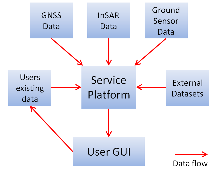
Figure 1 Schematic of PLIMM Service Architecture
Output visualised using GIS software through a user GUI accessible via a web-portal.
Space Added Value
InSAR Data
- 1900s: 68 scenes from 5th May 1992 to 12th January 2001 from the descending data.
- 2000s: Envisat 45 images from 13 Dec 2002 to 17 Sept 2010 from the descending track.
- 2010 – 2015 RADARSAT -2
- 2015- 2016– Sentinel 1a Ascending images where available
The GNSS sensors will use GPS and GLONASS signals, additionally Galileo signals will be used when available to further improve the accuracy, reliability and availability.
Current Status
The project was completed on 13th March 2019 and has successfully transitioned into the commercial phase. A number of the contracts signed during the project will be ongoing during this next phase. The project will be subject of a small extension to allow the exploration of utilising the various products developed to be used within a rural and coastal environment. This project extension will focus on the technical challenges envisaged when porting the products to be used in these environments but will also provide the consortium with the opportunity to refine and iterate the business model used in delivering the service.
Prime Contractor(s)

Subcontractor(s)