
Objectives of the service
The pilot-demonstration service has reached the following objectives:
-
On top of the existing OGOR platform, offer at parcel and farm level the yield forecast for the top three most grown crops in Romania: maize, winter wheat, and rapeseed, two months before the harvest time, updated every two weeks
-
On top of the existing OGOR platform, offer at UAT level and county level, the crop detection, and yield forecast, one month before the harvest time, updated every two weeks
The above objectives cover only the following geographical regions in Romania, selected by the density of farmers that are in our target customers: Câmpia Română, Piemontul Getic, Podisul Moldovei, Câmpia Banato-Crişană, and Podişul Dobrogei.
Users and their needs
The key customer segments targeted by our service are the farm owners, being interested financially to know in advance the outcome of the season to better reserve silos, distribution, and transportation.
The users are the agronomist engineers, interested to see how the crops are performing during the season and to measure the progress to the productivity goals set by the farm owners.
The pains (e.g., problems) and gains (e.g., benefits) are:
-
Our farm owners' (customers) main problem is related to knowing in advance the estimated productivity of their farms.
-
Our agronomists (users) have difficulties in assessing the impact of their agronomic decisions relative to the productivity goals set by the farm owners before the season.
Service/ system concept
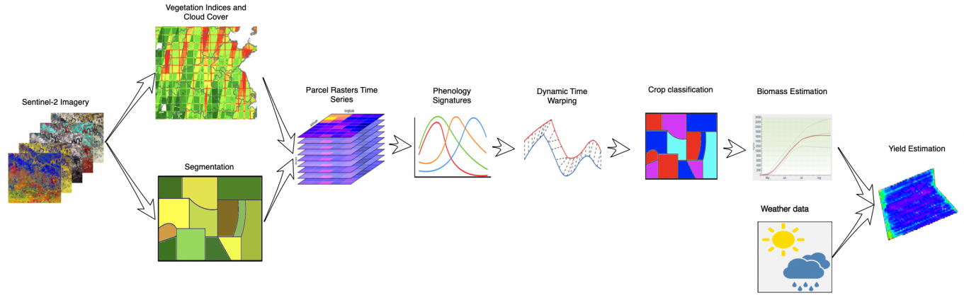
The service is provided as an extension of the existing OGOR platform, which currently serves up-to-date and historical parcel level vegetation maps and statistics to farmers across Romania.
While the end product is represented by maize, winter wheat and rapeseed yield estimates, users also benefit from some additional outputs: soil type layer, soil structure layer, mobile application (Play Store and App Store).
Space Added Value
The space asset used by our application is Satellite Earth Observation and in particular:
-
Sentinel-2 Level-1C (Top-Of-Atmosphere) and Level-2A (Bottom-Of-Atmosphere) products, which contain ortho-rectified (and in the case of L2A, atmospherically corrected) images for the spectral bands captured by the satellite's multispectral imager sensor;
-
Derived georeferenced raster products for cloud detection (FMASK) and several types of vegetation indices, such as the Normalised Difference Vegetation Index (NDVI) and the Enhanced Vegetation Index (EVI).
Historically, regional and national scale agricultural productivity estimations have relied on sampled, in-situ data. To compound on the data sparsity issue, some locales (Romania included) still score poorly on the public availability and transparency of agricultural data. In this regard, satellite imagery will act, as it has in other domains, as a great equaliser - by opening access to raw land data and its subsequent analysis; and, conditional on accurate classification of land attributes (such as crops), predictive analysis based on satellite imagery can over perform traditional sampling methods.
Current Status
The Final Review milestone has been successfully passed.
The service piloting was a success and it is now getting ready to be commercialised.