
Objectives of the service
The MoSCI - ECOSPACE user-driven product uses earth observation data to improve the lives of citizens, protect livelihoods, and help governments make good, evidence-based decisions in coastal and riverine settlements vulnerable to erosion and flooding.
The MoSCI - ECOSPACE product create value to customers by:
- integrating a range of monitoring capacities including space-based, airborne, seaborne or land-based observation systems – spanning over a range of spatial and temporal resolutions – into a centralised web-based tool;
- using standardised protocols for data storage, extraction, processing, analysis and (raw) data quality controlling;
- translating datasets into meaningful information for overseeing and managing risks to critical infrastructure in coastal and riverine settlements, thereby taking efficacy dividends from the very large amounts of climate data being created (in particular earth observation data and information).
| Horizontal displacements’ | ‘Vertical displacements’ |
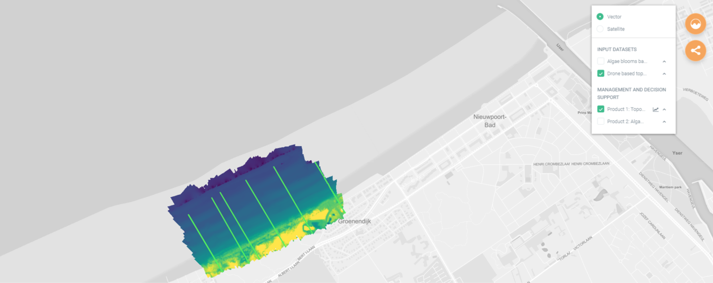 | 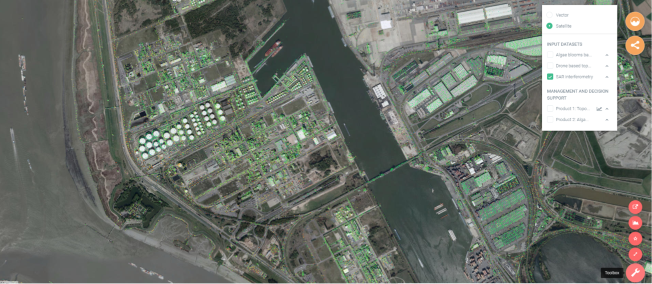 |
Image credits: IMDC
Users and their needs
The market of the MoSCI - ECOSPACE product is segmented into three groups of customers, who share traits such as similar interests, needs:
- Public water authorities, with different mandates and responsibilities for managing Critical Infrastructure and overarching economic, environmental and social systems. The engaged end-users in the demonstration project are ‘de afdeling KUST’, which has jurisdiction over the entire Flemish coast, ‘de Vlaamse Waterweg’, which is the agency of the Flemish government that manages the waterways in Flanders as well as ‘Geotechniek’, which is the geotechnical knowledge centre in Flanders having the task of investigating the nature and characteristics of the soil and predicting its behaviour surrounding critical Infrastructure (e.g. bridges, quay walls, dikes and tunnels).
- Utilities with responsibility for managing critical supply infrastructure (e.g. power supply), Contractors and Engineering Consultants, who share two main interests, needs. Firstly, a low-cost tool to monitor and make quick high-level risk assessments of critical infrastructure they engineered or built throughout the warranty period of the contracts. Secondly, to perform complex scenario analysis including stress tests to specific risk drivers (e.g. climate change) based on complex modelling and benchmarking against project performance targets. The engaged end-user is ‘TRACTEBEL’, a worldwide consultancy and engineering company active in the power, nuclear, gas, industry and infrastructure sectors.
- International Financial Institutions and insurance brokers that provide financial services to implementing Critical Infrastructure security and resilience. The ‘World Bank Group’ and ‘Van Vanbreda Risk & Benefits’ are interested partners in the demonstration project.
The MoSCI - ECOSPACE product is being demonstrated in Belgium and the West African countries of Côte d’Ivoire, Ghana, Togo and Benin.
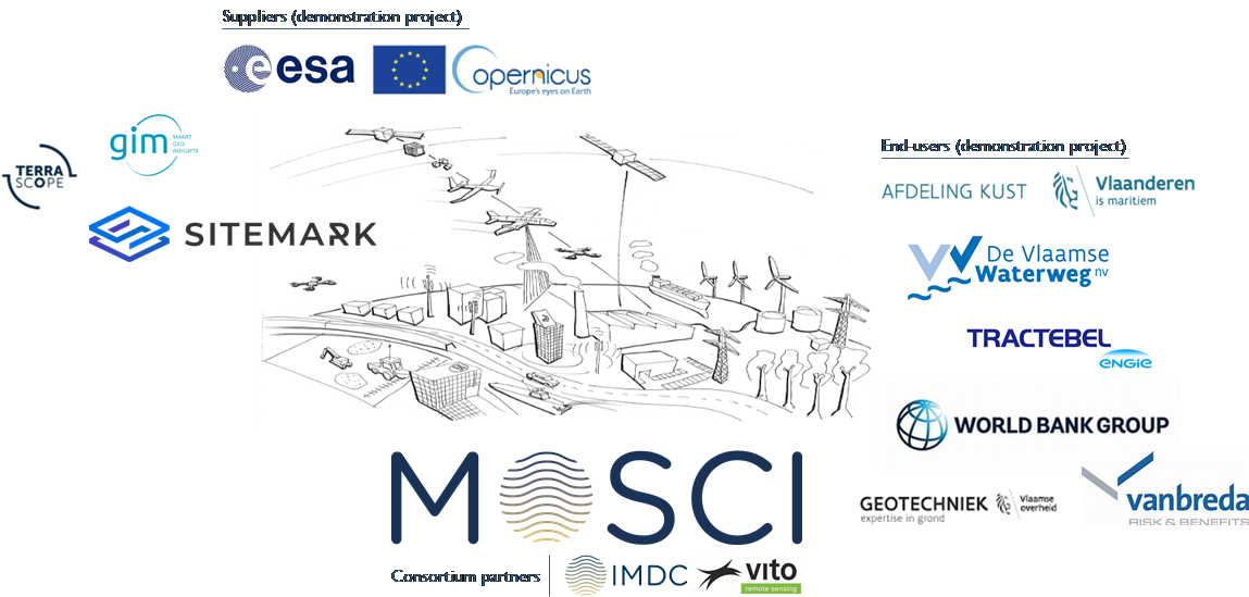
Image credits: IMDC
Service/ system concept
The MoSCI - ECOSPACE product draws from developments in open data and analysis, shared and interoperable software, computing power and other technical enablers of improved data science, risk assessment, risk modelling and reporting. The overall service delivers accurate, timely, relevant interoperable, accessible and context-specific data and analysis software code and services to better inform risk-aware decision making and adaptation strategies.
| Product Characteristics | Service to be delivered |
Automated post-processing Standardised protocols Support for multi-source data and coupling Data coupling Integrating Earth Observation datasets Integrating multi-source data spanning over a wide range of spatial and temporal resolutions | Data storing, extracting, automated processing and (raw) data quality controlling Integrating a range of monitoring capacities including space-based, airborne, seaborne or land-based observation systems – spanning over a wide range of spatial and temporal resolutions – into a centralised web-based tool Downloadable: maps, profiles, data series |
Identification and prioritisation of hotspots based on risk profiles and thresholds, including early warning Intelligence and complex modelling module | All above services plus prioritisation based on risk and an early warning system Translating datasets into meaningful information for overseeing and managing risks to critical infrastructure in coastal and riverine settlements at high level vulnerable to erosion and flood risks Downloadable: maps, profiles, data series, reporting |
| Intelligence and complex modelling module | All above services offering plus an intelligence and complex modelling module Translating datasets into meaningful information for overseeing and managing critical protection/trade/supply infrastructure at asset level Downloadable: maps, profiles, data series, reporting, modelling results on specific assets |
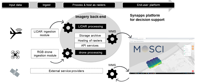 | 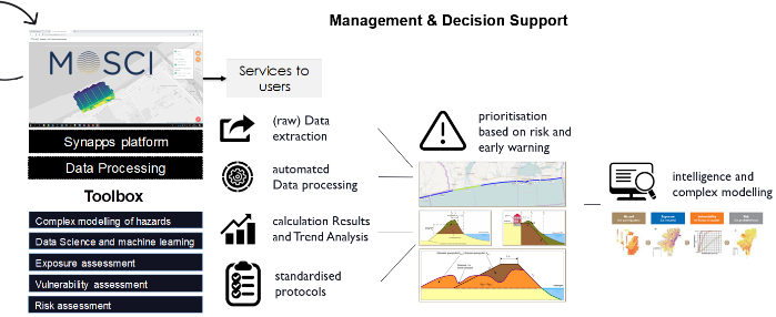 |
Image credits: IMDC
Space Added Value
MoSCI - ECOSPACE combines several space assets and couples the derived products with other products that are already used by customers. The first space assets are Sentinel-1 and RadarSAT which are used to derive subsidence information based on inSAR (Interferometric Synthetic Aperture Radar). The second space asset is Galileo which combined with drones provides crucial information for the correct positioning of the drone data and the derived topography information. All these data can provide information on e.g. the stability of CI and can be combined with existing LIDAR datasets obtained from manned airborne acquisitions. Finally, land cover maps are derived from Sentinel-2 and then used to derive exposure information along coastal and riverine settlements for damage and risk assessments.
Integrating the space assets allows faster assessments of the condition of ecosystems and protection structure to CI and, consequently, to act faster and better in case of damage or destruction.
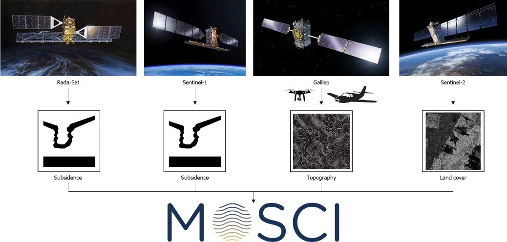
Image credits: IMDC
Current Status
The MoSCI - ECOSPACE product feasibility study is finalised and the demonstration project is ongoing through May 2022.
System Design and Development builds on the MoSCI - ECOSPACE prototype developed during the feasibility study and the iteration of user requirements and technologies feasibility. It further incorporates new research and innovation in both the imagery back-end and the SYNAPPS end-user platform for management and decision support (e.g. new and innovative methods/algorithms for data analysis, statistics and anomaly detection). The service is developed on a web- and cloud-based solution platform and on open-source codes and standard communication protocols.
At the end of the demonstration project, a fully operational MoSCI - ECOSPACE product will be ready service for commercialisation.