Objectives of the service
In sight of the growing piracy problem, this feasibility study called MAPP, for MAritime Piracy Prevention, has been launched to respond to an international need for improved situational awareness in the domain of piracy prevention. The study aims to investigate the technical feasibility and the economic viability of using space-based technologies in the fight against piracy. It will also build a roadmap for the future development of piracy prevention services building on enhanced information centres using improved data sharing among a range of stakeholders.
Users and their needs
The target users for this study are
- Shipping companies
- Situational awareness centres
- Insurance companies
Service/ system concept
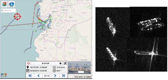
The ‘Keep in Sight’ service relies first on a hidden tracker installed onboard. This discreet, GNSS-free, autonomous equipment with a long battery lifetime will keep track of vessels in all circumstances and allow early detection of anomalous ship behaviour. The ARGOS satellite constellation offers an advanced “Doppler effect”-based positioning service which guarantees the location validity. This allows enriching the maritime picture with Earth Observation (EO) data at highest resolution.
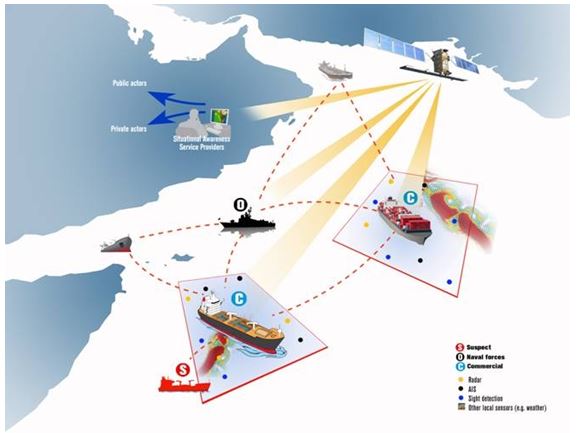
A “maritime crowd” reporting and information sharing service is a second option, still to be confirmed. A user-friendly interface will stimulate anonymous reporting through SatCom equipment to bring precious inputs to the shore to be processed into high value-added products and sent back to ships and their companies.
Space Added Value
Argos is a unique worldwide location and data collection system. The Doppler Effect positioning allow to locate ships with an accuracy of up to 250 m, it doesn’t require the implementation of a GPS receiver and offers very low energy consumption equipment design possibilities.
EO activated on-demand brings intelligence to detect non-cooperative surrounding targets around the attacked vessel to best understand the situation at sea best and plan the rescue and intervention operation.
Satellite communication (Inmarsat, Iridium, VSAT) is essential for data transmission over long distance when ships are at sea (terrestrial coverage along High Risk Areas is very poor). The crowd maritime service will fit with the lowest common denominator of existing on-board satcom capabilities. In addition, the role of GNSS is to automatically geo-reference and tag the transmitted information.
Current Status
The demonstrator phase to implement the ‘Keep in Sight’ service is going on and will be compteted in April 2017.
The maritime crowd service is a still of high interest but the business model and the on-going e-navigation standards are not mature enough to start a demonstration phase right now.
Prime Contractor(s)
Subcontractor(s)