

Objectives of the service
Roads use active traffic management technologies to detect incidents, respond to risks, prevent accidents, pinpoint traffic bottlenecks, reduce congestion and keep traffic flowing. The benefits are substantial: decreasing accidents by 35%, injuries and fatalities by 31% and congestion by 20%. Unfortunately, these technologies rely on expensive supportive infrastructure such as electrical and communication cables, making them prohibitively expensive at >£1M/KM. As a result, less than 4% of roads enjoy these benefits. Valerann has developed a wireless, solar-powered, multi-sensory solution to bring the benefits of traffic management to all roads, at just 20% of the cost of current solutions. By leveraging satellite communications and geo-positioning, the ITS Equant consortium aims to make Valerann’s technology more scalable and capable in roads where there is limited cellular connectivity. In doing so, the consortium will make the benefits of active traffic management available to all roads.
Users and their needs
Valerann’s users are organisations called road operators. These are often private organisations that are hired by local governments to maintain roads, monitor traffic, and respond to incidents. Their main objectives are to maximise traffic efficiency and safety, within their respective budgets.
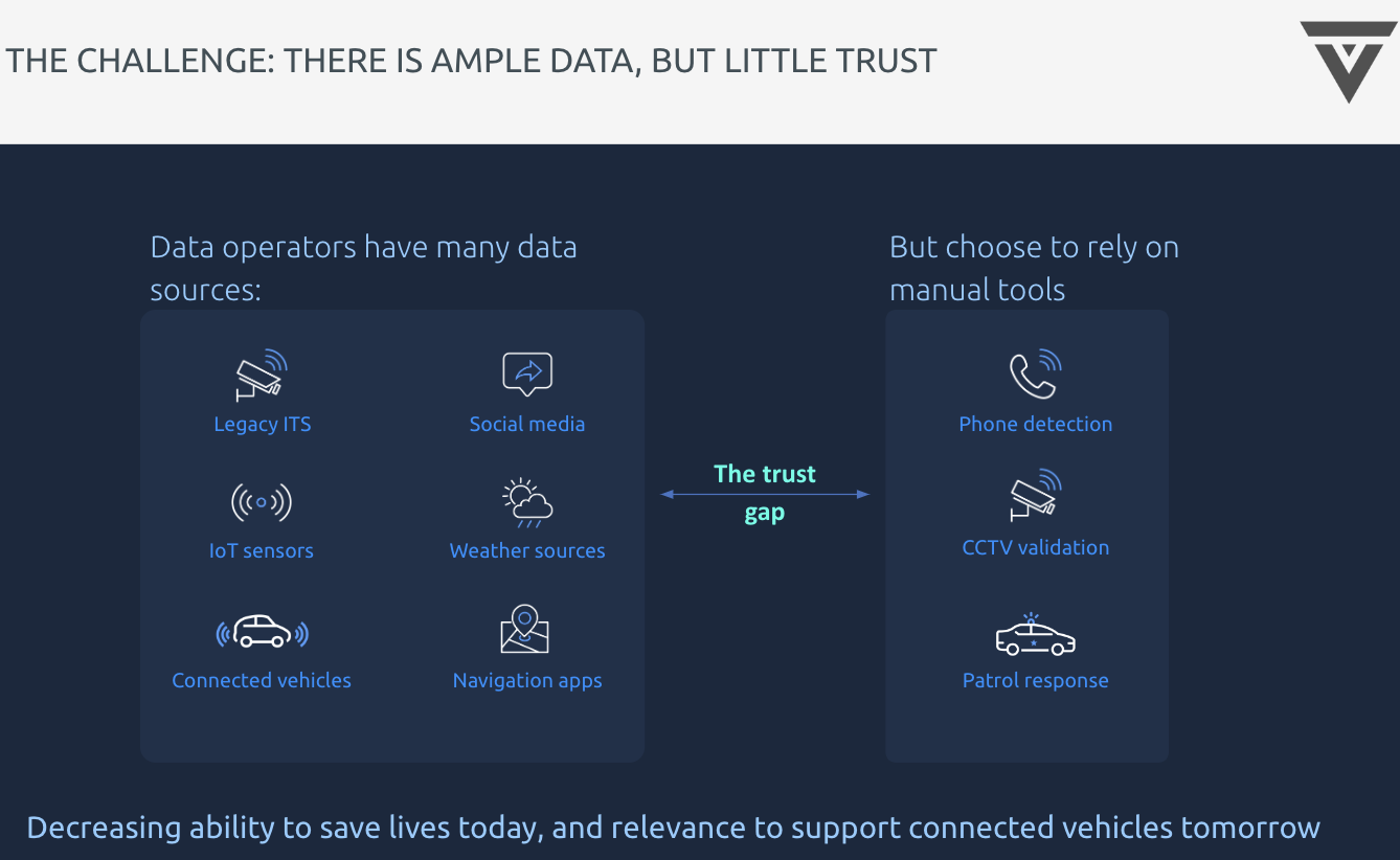
The biggest challenge these operators face is getting reliable information about traffic in their network, so they can make decisions about where and how to respond to incidents when they occur. Specifically, they must:
-
Detect and verify incidents when they occur, and understand their precise location, time, severity, and context
-
Identify and mitigate major risks to traffic safety
-
Determine the location of traffic bottlenecks as they occur, before they turn into congestion
-
Stay within a budget so that their entire network can benefit from these capabilities, rather than just a select few roads
Service/ system concept
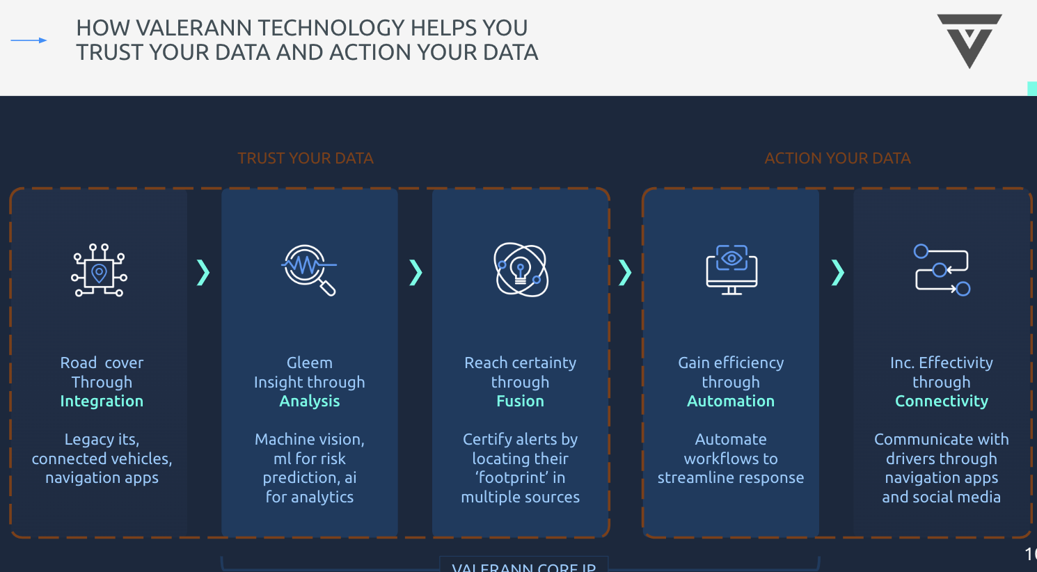
The use of ITS, reliant on traditional fixed road infrastructure (CCTV cameras, sensors, loops) has been instrumental in daily road traffic management. The rapid adoption of technologies -- ubiquitous use of smartphones, location-based services, such as maps, growing number of connected cars -- present additional invaluable set of real-time data, critical for monitoring road operations, especially in places not covered by cameras, camera blind spots and remote access areas. Floating sources real-time data, combined with data from on-demand services, such as historical weather data and weather forecast, fortify analytical models and provide a framework for simulating a broad range of scenarios for accurate and actionable data-driven decision making.
Our hardware-agnostic mission-critical software integrates with the existing road infrastructure,
ingests and continuously processes data streams of any scale or structure from all available disparate sources, such as floating and connected cars, loops, radars, social media, satellites. By taking data from unrelated data sources, leveraging our sophisticated proprietary AI and computer vision algorithms, we deliver best in class data fusion with precise events cross-validation, events prioritisation thus providing certainty for road operators, helping them to maximise road operations efficiency, increase road safety and achieve their KPI’s.
Space Added Value
Space technology provides three main layers of value-addition:
-
Expedited installation: Valerann’s algorithms today rely on an understanding of the distance between the sensors on the road. To ensure this is accurate, today (as part of the installation process) the exact location and distance is measured during installation. This creates a slower installation process that is very prone to error at scale, as contractors will be liable to measure incorrectly or record distances inaccurately. Using space technology, Valerann will enhance the installation process to digitally associate a precise GPS coordinate with each sensor as they are installed. In this way, the cloud will be able to calculate the precise location and distances between different sensors to inform its algorithms.
-
Expanded coverage: As a default, Valerann’s system uses cellular connectivity to send information from the gateway to the cloud. However, many roads do not have stable cellular coverage: in the UK, 47% of highways lack stable 4G coverage and 17% of highways have no cellular reception at all. Satellite communication will broaden the use of Valerann’s system to include such roads that currently cannot access it.
-
External interface: Valerann’s system is designed to inform decision-making by external stakeholders (external to Valerann). These include control centres, emergency response services, and (in the future) connected vehicles. These users require a standardised format to receive and transmit information of events. These formats rely on GPS coordinates. By instilling GPS coordinates into the basis of the system, it will enable Valerann to communicate and provide valuable info to all stakeholders
Current Status
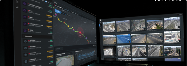
Following a successful deployment of Valerann’s system in two major toll roads in Costa Rica and Chile, Valerann has focused on sharing this success with multiple potential partners, who have shown interest in the solution. Valerann has already deployed its version of the Geo-accurate dashboard that integrates data from multiple sources onto a map component, highlighting the importance of GIS-based data fusion in 5 Control Centers across the world.
In parallel, the team has started testing different satellite communication modules with Valerann’s system to decide which module and protocol are best suited for the system going forward.
Valerann will be present and showcase its solution in the IBTTA annual tech conference and in ITS World Congress.