
Objectives of the service
Having an accurate forecast of available water flow is crucial for hydropower companies and water management authorities in order to optimize operations and improve efficiency.
In the frame of the ESA Integrated Applications Promotion (IAP) programme (ARTES element 20), Starlab has just started the second phase of the INTOGENER project, aiming at the development and demonstration of a new, operational, water-flow forecast concept, based on the assimilation of near real time measurements of geophysical parameters into a hydrological model.
The system makes use of measurements derived both from Earth Observation satellites (SAR and Optical instruments for the retrieval of snow cover and temperature maps), and from in-situ sensors (for temperature, precipitations, soil moisture, solar radiation, water level). Satellite links are used to transfer information from the field (remote mountainous areas) to the processing centre.
During a first phase of the activity, one basin in the Chilean Andes has already been equipped, and sound predictions have been obtained. In the next two years, in partnership with Endesa and the Pontificia Universidad Católica de Chile (PUC) and with the support of Hispasat and Future Water, Starlab will demonstrate the real-time operational capabilities of the system, as the last step before potential commercialization of the service.

Users and their needs
INTOGENER Demo is targeting water management applications. The more accurate streamflow predictions are, the better water management and energy efficiency can be attained, with the derived economical benefit.
The user area is renewable energy production with a focus on hydroelectric production companies. Starlab has established along the years a strong partnership with Endesa Chile, which is a key player in the region, being the main producers of hydroelectricity in Chile.
Service/ system concept
The INTOGENER service will provide flow predictions at certain points of a Chilean hydrological basin. These predictions will be produced by a distributed model that assimilates:
- Water level measurements retrieved from reflected GNSS signals in the main basin's lake, from which the available resource is assessed.
- Temperature, humidity, rainfalls and solar radiation information collected from automated weather stations.
- Snow Cover Area maps from Earth Observation data
A data collection platform (Satellite modem and software) will perform data acquisition and control the GNSS-R instrument by a satellite link.
Space Added Value
The space assets to be used include:
Communication satellites for transmission of in situ data from remote sites (not possible by terrestrial ways in remote areas)
GNSS Satellites for estimation of water level in remote lakes using GNSS-R instrument (Low maintenance, works in any weather, automated, allows large water lever excursion).
Earth Observation satellites to derive:
- Snow cover from SAR (RADARSAT) and optical sensors (MODIS). Huge geographical coverage compared to in situ snow routes
- Space-based Digital Elevation models. Very large coverage and availability compared to plane based or other methods.
- Land Use Maps. Large coverage and availability compared to other methods
Current Status
The INTOGENER Demonstration project was kicked-off on May 11, 2012.
On site deployment of the satellite communication system and weather stations was performed successfully during the first week of May 2013.
Some pictures of the installation can be seen below:


The operational service delivered water forecast predications to the user ENDESA on a weekly basis for the melting season 2013 – 2014.
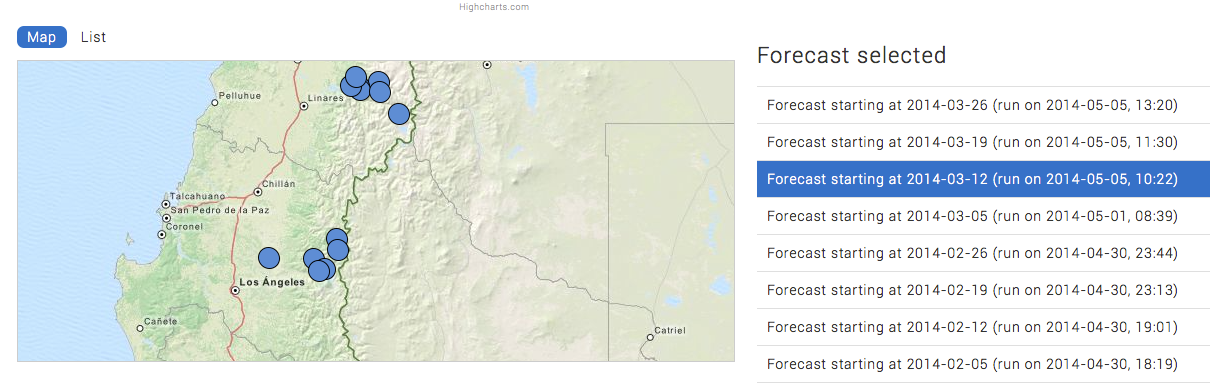
A web site was set-up to allow the user:
to view all the in-situ measurements stored in the database,
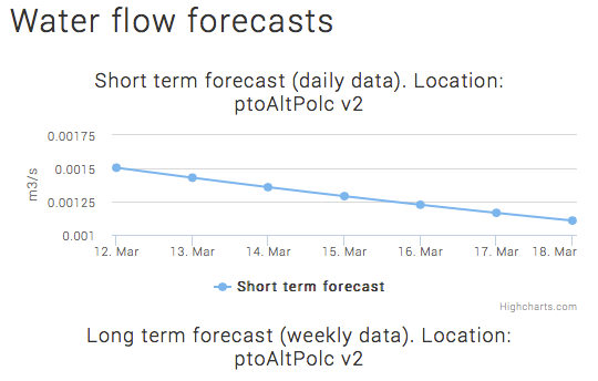
to download weekly water flow forecast reports
to visualise weekly water flow forecast reports on-line in the form of charts
to access a series of key performance indicators
to check the health of the system
A screenshot of the web site is shown below.
The service was run operationally for the melting season 2013 – 2014.
- 155 days, from the 25th of September 2013 up to the 26th of February 2014.
- 22 weekly forecasts (Every Wednesday 7am Chilean time) were provided to ENDESA.
- 10 SAR images for SCA computation were used.
- Daily processing of optical images for SCA computation was performed.
- Daily gathering of data from 2 dedicated weather stations (1 per basin), sending data by satellite communications, was performed.
- Daily gathering of data from more than 15 flows and weather stations from the DGA was performed.
The final review took place on May 27, 2014. The project is now completed.
As conclusions of the INTOGENER demonstration project, it can be stated that:
- INTOGENER service has shown good compliance with the operational requirements from the point of view of utilities as well as for the service capacities from a provider point of view.
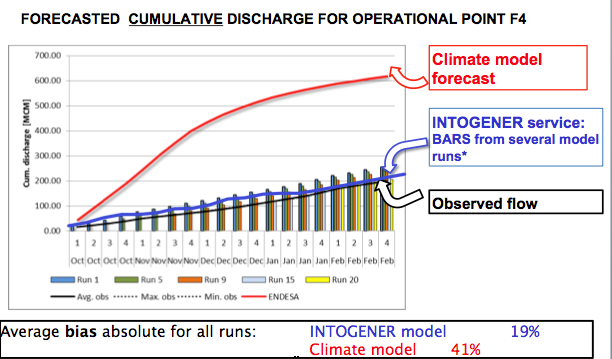
- Out of 6 forecast points, 3 gave very satisfying results (as the figure shows). In the other 3 forecast points, there were man made structures that were not taken into account by the hydrological model introducing, of course, some bias to the forecast.
INTOGENER has clearly the potential to become a financially self-sustainable flow prediction service for hydropower companies and water management agencies focused on remote mountain areas and unusual years, since it has demonstrated to improve short and mid term forecasts, crucial for energy production optimization.