Objectives of the service
The “Integrated Digital Satellite Platform for Urban Territorial Enhancement” (IDiSPUTE) project aims to offer municipalities and local authorities a range of tools to support land use planning and identification of hazards ((such as illegal building development) for the population through the use of information derived from earth observation satellites and with the use of innovative algorithms based on deep learning and artificial intelligence.
Users and their needs
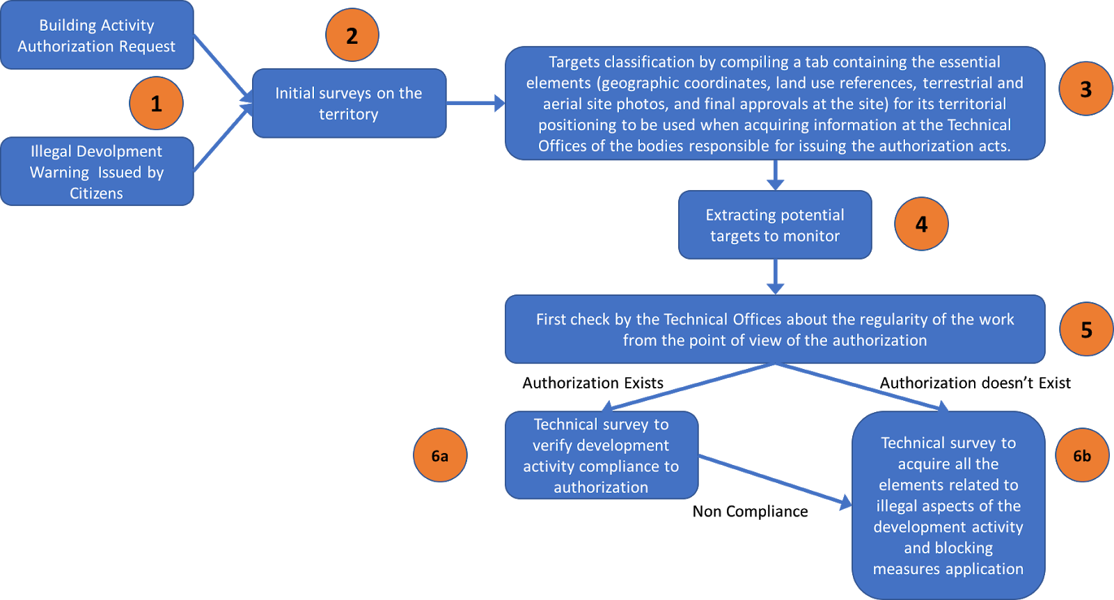
The control of the territory, for the prevention of abuses and illegal activities (first of all unauthorized construction/modification of buildings), is one of the main responsibilities of the municipalities and local authorities.
At the moment there are no integrated solutions that allow to have an overall picture of the whole territory and of the variations generated over time, currently the monitoring is only done on specific geographical areas based on citizens' reports.
IDispute aims to offer an innovative platform that can support public authorities in the process of monitoring the territory offering clear benefits in terms of reducing costs and in improving the ability to protect the territory.
The users involved in the project are deeply involved in the contrast of illegal activities over the municipality territory.
For the envisaged business model all European countries will be target countries, extending this domain to a worldwide vision in the next few years.
Service/ system concept
The IDispute solution is one of the vertical applications based on the EarthAlythics geo-information platform (www.earthalythics.com) that Penta Technology is developing to offer an innovative approach based on the "information as a service" paradigm.
iDipute will provide powerful tools for land and infrastructure management and for mitigation/prevention of illegal development.
IDiSPUTE aims at solving one of the problems causing the slow diffusion of EO-based solutions in the public administration market, i.e. the difficulty of extracting information from satellite images. This is mainly due to: i) the high technical expertise required to process data, and ii) the "tailor- made" approach, aiming at selling a project rather than a service. Therefore, there is still a big gap between expected and achieved results of EO solutions in the industrial market.

Space Added Value
IDiSPUTE services will be based on the use of Synthetic Aperture Radar (SAR) data processing. In fact: SAR sensors, thanks to their all-day and all-time capabilities, can provide the certainty of the acquisition necessary for several applications. Moreover, the launch of Sentinel-1, whose data are provided at free of charge by ESA, definitely removed the problem of the cost of images.
iDispute will provide information contained in EO images through i) a unique, flexible and easy to use (vertical web Apps and APIs) interface for satellite data customers; ii) high improvements in data availability, interpretability and exploitability (which means more data and higher quality data); iii) substantial savings in both operational time and costs, with a business model based on “turning pixels into information for the end-user”.
Current Status
Project completed at the end of October 2018.
In the coming months, the team will work on the definition of the business model and on the validation of a MVP with early "adopters" customer from both the public and the private sector.
It is intended to carry out such activities in a demonstration project planned to start in 2019.