Objectives of the service
The objective of ICWM for MED is to demonstrate the benefits of a service based on the integration of EO based products, Satellite Communication and Navigation solutions together with Terrestrial assets and crowdsourcing features, for the set-up of an improved coastal surveillance and water quality monitoring service in support to current practices on coastal areas for environmental monitoring and reporting, in particular to EU Directives. Targeted users are environmental agencies and coastguard authorities.
In particular the integrated solution provides access to real time information about the water status over the area of interest obtained combining EO mapping, Tracking Water Quality devices, other in situ measurements, modelling and crowdsourcing information. The resulting service intends to improve existing practices and solutions – both from EO and traditional at sea measurements – adding also a “time critical” component.
The pilot area is the central Tyrrhenian sea, interesting part of the Naples and the Salerno Gulfs. The area is subject to the requirements of the EU Directives and also includes a Protected National Park, part of the European network of areas of great environmental importance, adding several challenges related to the environmental protection and monitoring common to most of the Mediterranean coastal areas.
Users and their needs
The users are:
- ARPA Puglia (Regional Agency for the Protection of the Environment)
- Italian Coast Guard
They see the system as a potential useful tool for their monitoring activities. The demonstration itself can be seen as a marketing action towards them.
If the project succeeds in demonstrating the benefits for ARPA Puglia, the customers’ base has a good chance to be extended to the whole ARPA network.
The information needs include:
- chlorophyll-a concentration
- salinity
- temperature
- transparency
- identification of possible polluters (oil spill)
- detection of algal blooms
At service level the identified needs concern the provision of information in order to make use of them for issuing an alarm or to verify an alarm coming from other sources, with a high repetition frequency (>daily) and with the same accuracy both in the proximity of the coast and off shore.
The main identified gaps concerning current practices/technologies are related to the efficient combination of the following elements:
- capability to operate in (near) real time;
- capability to operate over large areas;
- costs optimisation over large areas and for long periods;
- high level of accuracy (including an high spatial resolution).
Together with ARPA Puglia and Italian Coast Guard, two main stakeholders are also involved into the project and in particular in the Pilot demonstration.
ARPA Campania
ARPA Campania shares similar needs with ARPA Puglia, so it showed its willingness in participating to the project, due to its interest in the use of satellite assets for improving its monitoring capabilities and to the planned location of the Pilot. It provided historical in situ measurements for the calibration of the water quality algorithms on MODIS and Sentinel-2.
Riserva Naturale Marina Punta Campanella Consortium (AMP Punta Campanella)
This park is located at the centre of the Pilot area and it provided support to the setup and the evaluation of the Pilot demonstration outcomes.
Both users are from Italy.
Service/ system concept
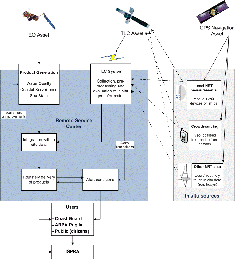
The integrated solution includes continuous water quality monitoring and coastal surveillance services based on Earth Observation (EO) data and improved through in-situ data from different sources, improved with respect to existing solutions by combining three different satellite assets together with Terrestrial (in situ) assets and crowdsourcing features.
The resulting integrated system allows to add a “time critical” component to provide information detailed and updated in short time (i.e. few hours) to the users and stakeholders.
In particular it provides access to real time information about the water status over the area of interest, including:
- Water Quality parameters
- Surface winds and waved
- Oil spill detection and forecast
- Position of anchored ships
It includes also:
- a Tracking Water Q (TWQ) device able to provide real time measurements of the same water quality parameters
- a crowdsourcing component, allowing to citizens to send geo-localised alerts (eventually including a photo) concerning environmental issues.
Space Added Value
The integrated solution includes three space assets: Satellite Communication, Satellite Navigation and Earth Observation.
In particular, three processing chains based on Earth Observation asset:
- Monitoring service providing Water Quality information.
- Coastal Surveillance service providing improved monitoring of illegal discharges activities from ships and assisting in following their drift.
- Sea State monitoring service providing wide scale information over the sea, such as wind direction and wave motion.
The Satellite Navigation asset is be used by the monitoring stations to localize their position and geo-referenced measurements and by the mobile applications to send geo-referenced alerts and/or pictures, useful for validating and enriching the EO-based data.
The Satellite Communication asset is exploited through a TLC system that allows the transmission of information (with support of the AIS protocol) from the mobile components and the monitoring stations to the Remote Service Centre, in order to enable their real time integration.
The Data Fusion Centre – based on the Rheticus™ system – completes the solution and is responsible for the orchestration of the different data flows and to ensure the interconnection among the different processing chain, deployed in different processing nodes. It has also the role of collecting all the information, validating and crossing them and to make the delivery to the users. It also acts as service provider aiming to implement a Decision Support System for the final users.
(see figure above)
Current Status
After the successful SAT meeting held the 15th April 2016, the integrated system was finalised and made ready.
The Demonstration Pilot was run successfully from June to September 2016 on the sea area of interest including the Naples Gulf and the Salerno Gulf, performing:
- automatic NRT processing of Sentinel-1 and MODIS EO satellite data;
- 5 campaigns mounting the tracking water quality (TWQ) device on a ship provided by AMP Punta Campanella around the Sorrento peninsula, together with traditional water sampling to perform laboratory analysis;
- automatic fusion of EO and TWQ measurements to obtain improved water quality maps;
- automatic processing of Sentinel-2 data;
- activation of the mobile app for obtaining local crowdsourcing information on the area of interest.