Objectives of the service
In the fight against climate change and biodiversity loss, sustainable forest management has turned into an urgent yet complex challenge requiring high-performance monitoring facilities. However, in most countries, forestry remains traditionally a local business activity based upon static information from various types of sources and lacking regular updates. Usually, forestry experts offer management plans and monitoring services which often are one-time information. Additional consultancy services are required to keep this information up-to-date thus further increasing the cost to produce updated information.
To tackle these problems, ICT4Forest will harmonise, in a cost-effective and seamless way, different sources of forest and Earth Observation data into a unique digital service platform – the Wuudis platform – offering integrated and dynamic forest monitoring and management features.
ICT4Forest added-value is twofold: i) to solve the problem of forest resource data being static (maps/GeoTiff and reports) thanks to regular updates through the Wuudis IT platform, and ii) to offer reliable and harmonized information coming from multiple temporal data sources that are processed automatically (satellite images to generate updated maps).
In practice, the ICT4Forest service is the result of the fusion between Wuudis forest management service components and SPACEBEL satellite data expertise in the forest monitoring domain. Alongside, the service will be available at a reduced price for first customers in order to promote the system as a fore-runner in forest data digitalization.
Users and their needs
The key user segments targeted by our service are:
- Forest management associations
- Forest authorities (e.g.: national and regional forest administrations)
- Forest owners
- Forest service companies and Forest industries
User needs:
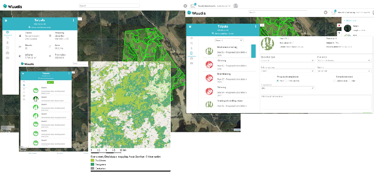
- Dynamic forest inventory and forest health monitoring services easy to integrate to 3rd party IT systems and available on an easy-to-use industry specific web-based and mobile application such as the Wuudis tool.
- Automatic and quick forest damage (due to fire, snow, storm etc.) mapping services available over regional areas.
- Digital tools for managing silvicultural operations in forests.
Challenges to meet user needs:
- Cost savings and increase in revenue thanks to updated forest resource data at fingertips together with forest planning and operation digital tools.
- Time saving and increase in user satisfaction by replacing multiple excel sheets, documents, static maps etc. with an easy-to-use app and service.
- Offer to forest service companies an easy-to-use mobile solution for work quality monitoring purposes and allow them to be connected with forest owners thus ensuring more income.
- Allow forest industries to obtain the right species of wood (and hence quote better prices) by offering accurate stand level forest inventory data.
- Allow forest management associations to use IT solutions (improving work efficiency and operating costs) in order to better serve their customers (i.e. forest owners).
Targeted countries:
- Spain
- Finland
- Belgium
Service/ system concept
The ICT4Forest service proposes an orchestrated approach by using forest management plans, EO data and field data (calibration/verification purpose) in order to fulfil the proposed user needs.
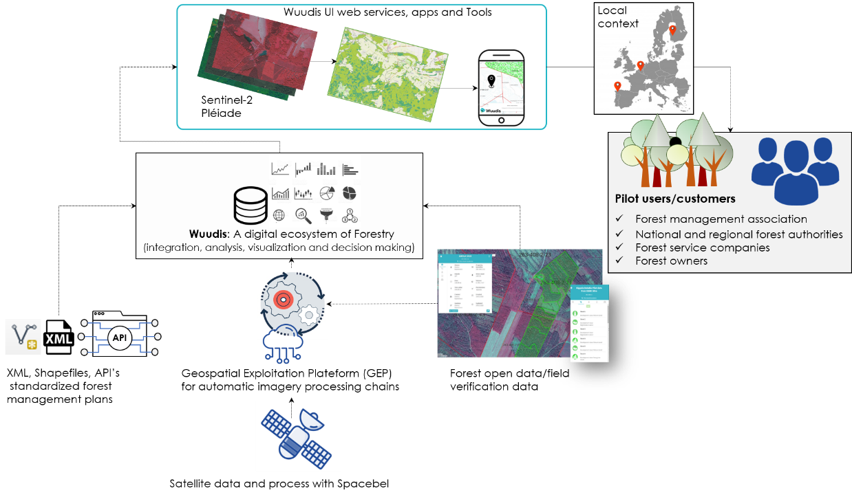
ICT4Forest exploits the power of EO data to update the forest management plans in combination with the Wuudis platform to provide seamless digital solutions to customers. In addition, thematic maps based on EO data are provided on the Wuudis platform. The Wuudis mobile application is also used to collect information in the field at parcel level as reference for ML/DL models to generate regional forest maps. Moreover, the tool acts as field work monitoring tool.
The dynamic forest inventory monitoring produces specie repartition maps and forest attributes (density, volume, height, basal area) derived from individual tree detection. Ancillary data (soil, slope, altitude etc.) are also available depending on the country.
The automation of the different services and processing are implemented in the SPACEBEL Geospatial Exploitation Platform (GEP) whereas the framework of Wuudis ensures the sustainability of the proposed services and delivery to end-users.
The SPACEBEL GEP collects and prepares necessary data, executes automatically recurrent processes to produce information, creates metadata and makes results accessible into a catalogue which is transmitted to the Wuudis platform for a final set of digital products intended for customers.
Space Added Value
Forest management plans and EO data are complementing each other. The first one is a basic tool for management and an industry norm for professional foresters. On the other hand, EO data allows the provision of dynamic forest resource information at a regional scale.
The EO processing and the implementation of the service rely on a good comprehension of the local forest situation. Building reliable reference datasets to train the classification process is another key step in the EO data processing. The Wuudis mobile application helps to collect this information in the field serving as input to EO processing chains.
The key satellite activities are:
- Forest inventory: based upon Very High Resolution imagery such as Pleiades, the inventory is performed through tree species and tree crown identification.
- Dynamic health monitoring status: High Resolution Sentinel-2 imagery are used along with change detection, machine learning or artificial intelligence to detect areas affected by drought or diseases.
The regular and repeatable acquisition of satellite imagery, especially Sentinel-2 data, ensures the dynamic nature of these services. .
Current Status
The proposed services aim to provide relevant information for forest managers, forest experts, GIS experts, contractors, forest owners or related stakeholders by combining satellite and field information through the production of forest resources map layers, which are gathered in a web platform intended for forest management.
On one hand, Wuudis Solutions is well-known for its widely used software services in the area of forest management and data collection on the field in Finland and Spain. On the other hand, EO based algorithms for forestry mapping are already implemented in the SPACEBEL Geospatial Exploitation Platform (GEP). The project is an opportunity to improve the accuracy and consolidate the results of these services through Artificial Intelligence and Artificial Neural Networks. The project also aims at adapting the methods and platform to different forest contexts in four countries (Belgium, Finland, Portugal and Spain). ICT4Forest also implies production cost reductions via the implementation of the results in the Wuudis platform solution.
The IT infrastructure of Wuudis is well developed and ICT4Forest offers an embedded set of tools related to dynamic forest monitoring and management on the Wuudis platform solution. Wuudis infrastructure can be interfaced easily with any third-party software solution and provide specific customer reports for decision making. The project mainly focuses on use-cases in Belgium, Finland, Portugal and Spain with a series of early customers as the backbone of future commercial exploitations.
At this stage of the project, the FAT meeting took place on 14th April, 2021 via a teleconference.
Currently, the project focusses on 10 pilot customers based on defined use-cases. It is possible to consider more pilot customers at this stage of the project. Usually a use-case runs for approximately 6-9 months during which we collect the specific user requirements and thereafter provide a customized solution. The organizations and companies participating in the use-case will get early access to the solution customized to their needs.