Objectives of the service
The objective of the study was to undertake a feasibility study addressing the role and the added value of space assets into the optimisation of freight transport through European ports.
To achieve these outputs the study addressed the following questions:
- What are the shortcomings and challenges in the existing routing and scheduling processes for moving of freight traffic through ports?
- How can satellite assets be combined as part of a solution? What would a service look like? What is the value-added of the satellite assets?
- What are the user requirements that would help define a service to address these issues?
- How can the solution designed during the study be validated?
- How attractive is the solution and what critical factors must be addressed to arrive at a sustainable solution? Are there any new satellite services required that could benefit the sector?
- What is the roadmap to a sustainable operational service?
- What other users and stakeholders can be engaged in a future demonstration project?
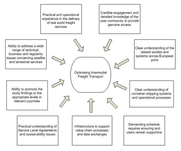
Figure 1 depicts the key factors that werea ddressed in order to successfully respond to the study requirements and to produce the most credible approach.
Users and their needs
The users targeted in this feasibility study are those which could benefit from optimising intermodal freight transport include e.g. ports, hauliers, shipping lines, railway operators, inland waterways, storage facilities.
Stakeholders include e.g. (local) authorities, customs, communication service providers, road and water authorities.
The users and stakeholders who initially expressed their interest to provide the project with their support included ACL (shipping company - Worldwide), JMD (haulier - UK), Peel Ports (port - Liverpool) and representatives from the port community of Bremen.
Service/ system concept
The following services have been defined:
- Dynamic Vehicle Booking Service (VBS)
- ETA and Tracking Information Service (ETA)
- Environmental Data & Routing Optimization Service (RO)
- Container Transport Order Service (TOS)
The Tracking module retrieves the location of the vessels and of the trucks. It uses satellite AIS data to track the vessels and also uses GPS data to track the trucks. This information can then be displayed on a map to the relevant actors to help them to plan requisite resources and to be used by the ETA service and in due course the DVBS service below. Smaller truckers will be able to transmit tracking data and provide this to the Hauliers so that Haulier subcontractors will be able to access the other I-PORT services. Users can see the vessels arriving to aid with resource planning.
The ETA & Route Planning module will take into account the location of the truck, the destination of the truck and will use an HGV-optimised route planner to calculate the most suitable route. The computation will also take into account traffic information to either provide a new route or to take into account the delay for the calculating the ETA. Port terminals, haulier and shipping lines will be able to view a list of trucks - according to the systems ETA calculation - that will probably be late (or early), thus allowing redistribution of slots. They will also be able to view in real-time the location of vessels to aid with resource planning.
The Job Management & Electronic Documentation will focus on collecting data related to transport jobs for container import or export and providing this data to the DVBS service so that I-PORT can match the vehicles to the bookings at the ports. In addition the service will provide data to the trucker to help with documentation required for port access e.g. security PIN number for access and container identification. Hauliers will be able to transfer and jobs to smaller subcontractors to ensure that are able to use the other I'PORT services.
The Dynamic Vehicle Booking System (DVBS) module will complement existing Vehicle Booking Systems (VBS) or reservations systems by enabling adjustment of vehicle slots in the port terminal. I-PORT will provide a framework/component that will enable currently deployed systems to be dynamic. In case there is no currently deployed system, I-PORT will provide a vehicle booking system with standard functionalities offered by existing vehicle booking systems or a link to the port/terminal reservation or pre-announcement system if that exists. The focus of DVBS is allowing slots at port terminals to be reassigned depending on trucks ETA. This allows for optimisation of slot usage to enable rebooking when trucks are delayed or when they may be early. Once a slot has been booked, it can either be changed manually by the personnel at the port terminal or the Haulier by invoking this service. The slot can also be changed automatically - subject to rules to be agreed by the port/terminal - by the system via the ETA calculations provided in the ETA & Route Planning module. The slots which will be missed are freed up and made available for rebooking.
Space Added Value
The following space assets are included in the integrated solution providing added value:
- GNSS (GPS) To be able to provide localisation and tracking of vehicles, I-PORT will rely on GNSS satellites with options including GPS, Gailleo and EGNOS all being considered. GNSS data provides enough accuracy and is very accessible due to widespread integration in many different devices. The positional data from the vehicle OBU will periodically be transmitted to the I-PORT backend via GPRS/3G mobile networks, where it will be inserted into the central data store. This positional data will then be accessible by authorized actors and used in internal ETA calculations.
- Satellite AIS - The AIS is an automatic system used by vessels to identify each other's location, direction and speed by transmitting on the Very High Frequency (VHF) band. It is mandatory for all ships with gross tonnage of 300 tonnes or more to carry an AIS device. At sea level, AIS transmissions have a typical range of around 74 km, but can be read at a much greater distance by Low Earth Orbit (LEO) satellites with built in AIS receivers. S-AIS typically operates in constellations of polar orbiting satellites, which continuously listen for AIS signals and upload them to one or more S-AIS ground stations. The data is then analysed and updated in a central database. The drawback with S-AIS is that due to the larger distances between the transmitter and the receiver it tends to get less effective in crowded areas such as close to ports.
Current Status
The feasibility study has been completed and is presently developing into a demonstration project, leading to a pre-operational service.
A User Workshop was held at Mersey Maritime in Liverpool on the 15 December 2011 with the objective to understand the needs and opportunities regarding optimisation of intermodal freight transport through ports. Representatives of the user community included Atlantic Container Line, Peel Ports and JMD Haulage along with the local sector bodies Mersey Maritime Group and The Mersey Partnership.
Based on the technical architecture, the analysis of the current technologies for each of the components and the interface required for the I-PORT service, the solution is considered feasible. During the proof of concept the critical aspects of the proposed service were tested and proven to be feasible.
The non-economic viability aspects of the I-PORT project were reviewed and found that perhaps the biggest threat is the non-participation of major players at a port in the program. We believe based on the current level of support that this issue is manageable. To ensure it is easy for the ports and terminals to integrate with the I-PORT service the link to the vehicle booking systems must be easy to integrate and adaptable as each port/terminal will have different proprietary VBS systems with their own integration requirements.
The feedback received back from the user groups during this feasibility study has been encouraging and in reviewing all aspects of the feasibility it is observed that there is indeed a significant opportunity to improve the optimisation of intermodal transport in ports. The proof of concept provided evidence to the users that the I-PORT service would be technically feasible, including the feasibility of integrating the I-PORT demonstrator to existing stakeholder systems.
Given the evidence presented in the feasibility study there is now strong support amongst the user community for a demonstrator project. These users include three major port communities, two in the UK and one in Germany; three major international container shipping lines, with services covering Asia/Europe and North America/Europe, who use the respective port communities and three hauliers who are suppliers to the respective shipping lines.
We also have interest from relevant port community systems providers. The economic analysis indicates that for an operational service the support of 5 port communities would be sufficient to sustain the service. We believe based on the current level of support that this level will be achievable.
A proposal for a demonstration project will be submitted during 2013
Prime Contractor(s)
Subcontractor(s)


