
Objectives of the service
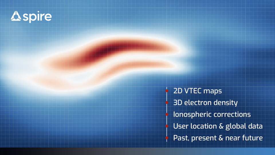
Image credit: Spire Global UK, Project: HRIDE
The ionosphere is the main source of error for single frequency GNSS users, resulting in positioning errors up to 5 m [Teunissen and Montenbruck, 2017]. Users of precise positioning algorithms (such as Precise Point Positioning (PPP) and Real Time Kinematics (RTK)) experience much smaller positioning errors, but these may be at the expense of much longer convergence times. Having an accurate, reliable and close to real time ionospheric modelling solution will allow all of these users to improve their positioning accuracy capabilities.
The HRIDE project aimed to demonstrate the use of the Spire constellation of Low Earth Multi-Use Receiver (LEMUR) satellites to provide improved ionospheric solutions. Space-based ionospheric Total Electron Content (TEC) observations can be combined with ground-based TEC and an empirical 3D ionospheric model using data assimilation techniques. The impact of using the improved ionospheric solution from the Spire data assimilation model (Spire TEC Environment Assimilation Model (STEAM)) on GNSS positioning errors was evaluated by industrial and academic test users via an API also developed as part of this project.
Users and their needs
The HRIDE framework is targeted at users who require low latency, high fidelity information on the global three-dimensional state of the ionosphere. This includes developers of autonomous vehicles, government and commercial precision GNSS users in currently underserved regions, and users who require global ionospheric situational awareness such as airlines and satellite operators. Furthermore, ionospheric data and models are used in academic studies of lithospheric/ionospheric coupling that may lead to better warnings of seismic activity. Users’ needs are related to the quality, latency, and reliability of the ionospheric information:
- The quality must be high enough to provide tangible value over competing solutions
- The latency must be low enough to inform relevant decision making processes
- The service must be reliable enough to be used as part of the relevant operations
Fulfilling these needs is challenging due to the sparse and heterogeneous nature of the available ionospheric data. Spire can help to meet them by using its nanosatellite constellation to produce new space-based measurements which fill in data gaps in the existing solutions, and producing a reliable, low latency combined data assimilation product.
Service/ system concept
The central aim of HRIDE is to produce an accurate real-time 3D electron density solution by combining Slant Total Electron Content (STEC) observations from ground and space-based receivers with a background ionospheric model. This is done in the STEAM 3D data assimilation model. By improving the electron density solution in 3D we are able to provide STEC values tailored to individual users (e.g. STEC values and errors for user defined ray paths) as well as other derived products, such as 2D Vertical Total Electron Content (VTEC) maps in the form of daily or 15-minute IONEX files, and selections of STEC and/or VTEC value(s) and error(s) for user specified ray path(s)/areas. Further, a machine learning (ML) system has been developed to provide 2D VTEC forecasts so that the ionospheric solutions are available to the user for past, current or future dates and times.
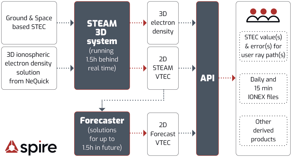
Image credit: Spire Global UK, Project : HRIDE
Space Added Value
The Spire constellation of LEMUR satellites provides low-latency ionospheric TEC data derived from in-orbit GNSS observations. This complements other data obtained from ground networks of GNSS receivers. The advantage of space observations is to allow expanded data coverage over the oceans and other areas with less dense observation networks.
The HRIDE project has shown that incorporating both ground and space-based observations in the STEAM data assimilation scheme provides a better representation of the ionosphere with reduced errors compared to assimilating only ground data. These improvements are also present when using STEAM ionospheric maps as a source of corrections for Single-Point Positioning algorithms, resulting in reduced positioning errors
Current Status
The HRIDE project has successfully:
- Developed and validated the STEAM 3D ionospheric data assimilation model. The near-real time 3D ionospheric solution has been verified against independent ionospheric models such as the Madrigal and IGS models.
- Developed a machine learning 2D forecast model. This provides stable and useful real time and near-future ionospheric solutions and related errors to customers
- Developed and tested an API providing the ionospheric solutions to users. The API implementation has been tested by users from academic, governmental, and commercial organisations all of whom successfully obtained their requested solutions.
- Demonstrated the use of the STEAM solutions to provide corrections for positioning
The STEAM 3D system combines slant total electron content (STEC) observations from ground and space receivers with a 3D solution from the ionospheric model called NeQuick to produce more accurate 3D electron density and 2D VTEC estimates and errors in near-real time which are stored in a database. The 2D VTEC solution from STEAM is forecasted up to 1.5 hours in the future and also stored in a database. Users can access these various 2D solutions and their derived products via the API.
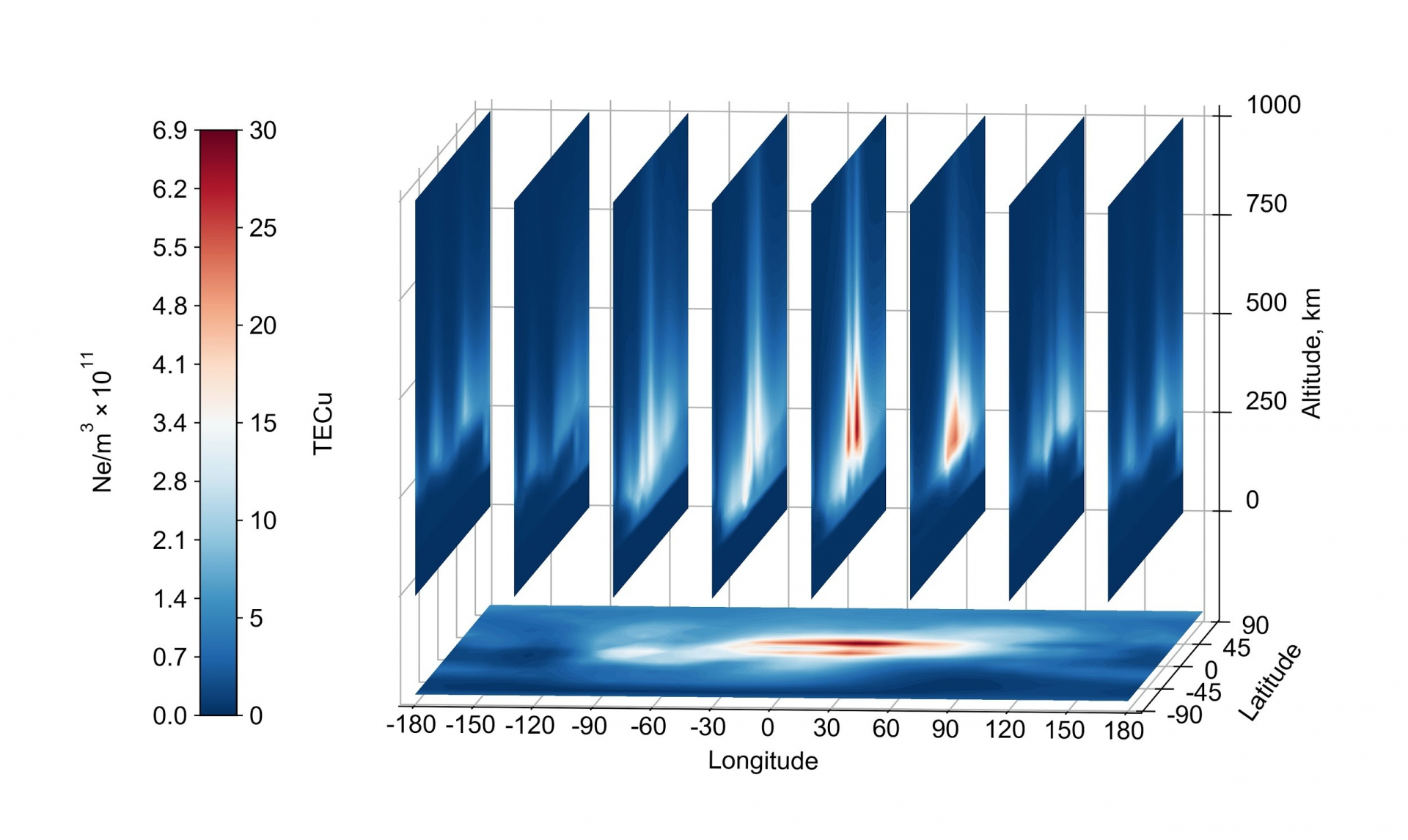
Visualisation of our 3D electron density profile seen through vertical slices plotted over 2D VTEC map on the horizontal axis
STEAM, the 2D ML forecaster and the API are all continuously running and available to provide output to customers.
Spire’s machine learning models for seismic forecasting have demonstrated that ionospheric data can provide better than chance forecasting performance. However, this performance was not competitive with a statistical benchmark model or with the neural network if it already had access to information on recent and historical seismic activity. Consequently, the system has not been put into operation.