
Objectives of the service
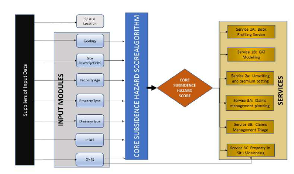
Hi_Ground brings new and original subsidence risk profiling services to the UK Property market, driven by our unique Core Subsidence Hazard Score which integrates and weights the key drivers of subsidence (property age, type and construction, soil type, tree location and drainage) to give a single Hazard Score.
This score is delivered:
- Basic or detailed
- Property or postcode
This score can be used to identify, validate and manage subsidence risk – across a property portfolio or an individual property such as creating an insurance quotation.
Users and their needs
The target users are all keys disciplines within the UK residential property market - insurance (insurance companies, re-insurance companies, actuarial service, brokers, risk managers and subsidence management claims providers), lenders (mortgage companies), conveyancing (house buying market) and public/private property portfolio management.
The markets are looking for better, cost effective information in which to increase knowledge of the areas of subsidence risk in the UK - better information = better decision making = improved performance.
Service/ system concept
Hi-Ground delivers modular service options to the target markets applicable to a range of business operational areas:
- Risk profiling and mitigation management
- Underwriting and premium setting
- Claims management
These are all built from our new and unique Core Subsidence Hazard Score, which is derived from the weighted integration of subsidence key trigger input datasets. This algorithm has been verified by Property Assure’s significant subsidence claims database, and calibrated by the National Physical Laboratory.
Space Added Value
The extent of monitoring ground movement, the triggers across a significant geographical area and the need to convert a ‘static’ profiling tool into a predictive service lends itself significantly to the application of satellite technologies.
InSAR data tracks wider area changes in ground movement. Integration of this data improves the quality and reliability of the Hi_Ground service. The Core Subsidence Hazard Score is designed to incorporate InSAR velocity data to demonstrate not just the risk of subsidence but the propensity for actual movement. In addition the development of InSAR allows the ability to identify ground motion that will lead to subsidence allowing early intervention and mitigation.
In addition, GNSS sticks have been effectively used on specific claims locations to track real time ground motion (in comparison to traditional measurement systems which rely on a site visit for the collection of level monitoring data).
Current Status
Demonstration project was completed June 2018,
Commercialization is underway with first customer secured on agreed terms.
Prime Contractor(s)
Subcontractor(s)


Status Date
Updated: 22 February 2019