
Objectives of the service
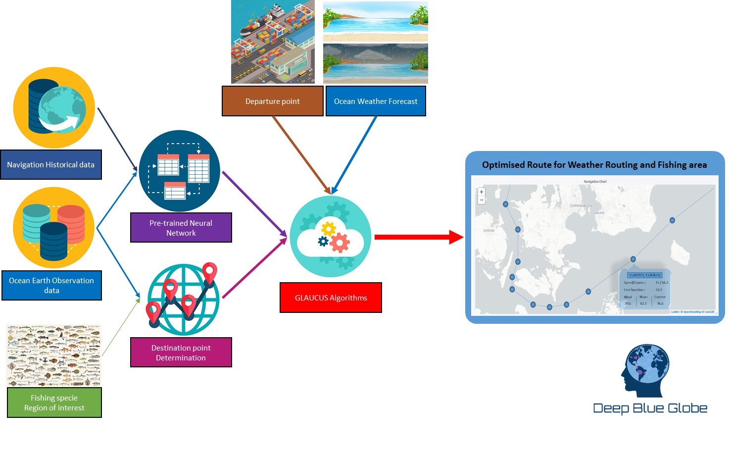
GLAUCUS is an end-to-end system to help fisheries to optimise their navigation routes and identify the best fishing grounds, dynamically updated to know where it would be more convenient to fish them during the fishing trip. The system will allow fishermen not only to locate the fishing grounds and the best time to fish in them over time but will also provide the optimal route to navigate through the seas, between fishing grounds and/or to the ports.
GLAUCUS is an artificial intelligence solution that can help fishermen to increase their productivity by reducing the navigation time and selecting the best fishing grounds.
The proposed service provides a solution addressing two different but related problems:
- The need to minimise the navigation time between fishing grounds and/or ports.
- Identification of the best fishing grounds.
In addition to the obvious operational benefits of addressing those problems, GLAUCUS is also aligned with new regulations affecting fisheries operations, like the ones issued by IMO regarding the fuel consumption and carbon emission footprint and the legal conditions to operate in a fishing ground.
Users and their needs
The existing services, although providing useful information for fishermen, have some weaknesses which can be summarized in the following points:
- Decisions are based in qualitative information which is visually processed by a human. This means that, with the existing solutions in the market, optimisation usually achieves ~5% with respect to no optimisation of the journeys when there is a higher potential optimisation if quantitative information is included in the process.
- Update of the planning routes require a lot of manual intervention to perform a standard update.
- Identified marine and weather conditions to select a fishing ground vary over time and it may happen that, by the time the vessel reaches the fishing ground, there was another one with better indicators. No information is provided about a global fishing and navigation plan to maximise the capture of the desired fishes, only immediate and local information.
Fishing ground identification and route operations heavily rely in the expertise of the senior fishermen to take decisions
Initial services are developed for any fishery operating in the Atlantic Ocean, but service could be extended worldwide.
Service/ system concept
GLAUCUS addresses the customer pains, identified by the fishermen, while providing at the same time added value to set more efficient operations practices and reduce costs:
- Provided navigation route is based on deep learning techniques using processing quantitative information regarding weather conditions instead of qualitative information which is processed by the captain of the ship. This means that a real optimisation process take place, improving over time since the neural network will improve its accuracy when including more navigation data from the fishery. Therefore, a reduction of 10-15% in the time of the journeys (given a constant engine rpm), instead of ~5% which has been traditionally achieved, is feasible based on preliminary analysis and papers.
- Capability to automatically replan the optimal route will be provided, with the acceptance of the captain of the ship, removing all the required manual tasks to re-plan the navigation route.
- Both, the optimal navigation route and the indicators regarding the potential of the fishing grounds, is computed and forecasted over time, providing a global optimisation of the fishing plan maximising the global results.
- Expertise about the fishing grounds with higher potential to capture the desired fishes can be captured in a model/algorithms to be used by GLAUCUS. This imply that the fishery will be able to capture the know-how of the most experienced fishermen in their staff, being less exposed to the risk of “brain drain” in the company if they left.
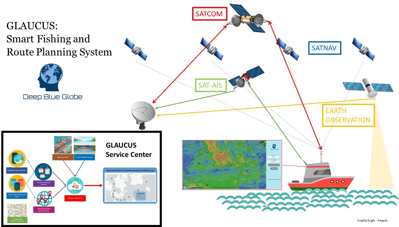
Space Added Value
GLAUCUS is only possible thanks to an intense use of space assets. Vessels historical and current positions are gathered thanks to SAT-AIS, which are used to plan the future routes that require Global Navigation Satellite Systems (GNSS) to ensure navigation across seas and oceans.
Satellite Earth Observation is used to determine the ocean state conditions which are essential inputs for determining the optimal fishing grounds and routes and its associated weather forecasts.
Finally, intense use of Satellite Communications are required to transmit and receive information in the vessels and the GLAUCUS Service Center.
Current Status
This project has been executed as part of ESA Kick-Start focused on the Atlantic Area. Proposed service implementation has been discussed with fisheries operating in the area that confirmed the user need and willingness to use the service at the proposed price.
A mock-up version has been developed to show customer how real user interfaces and interactions will look like.
At the completion of this activity, Deep Blue Globe is looking for customers and partners willing to test GLAUCUS in real conditions and subscribe for an early adopter programme.
If you are interested in the service, you would like to become a partner or you would like to know more about GLAUCUS and/or Deep Blue Globe, please send an email to: