Objectives of the service
Airports are often organized in independent cells, or silos, focusing on their own businesses. There is little information circulating between those silos.
We are convinced that all actors of the airport ground operations could benefit from better, accurate, real-time information providing instant insight.
The airport itself benefits from a consolidated dashboard view that summarizes ongoing operations and rotations.
Unfortunately, actors are seldom convinced they could benefit from information sharing, concerned to share some of their business activity to others.
Our approach is to have a non-intrusive, bird-eye view of airport activities, without disrupting silos habits and way of working, and making real-time information available to everyone. All individual actors of the airport ground activities, and the airport as a whole, can benefit from this information, take better decisions, ensuring smooth operations and coordination.
GIP, the Geo Intelligent Platform, is a platform designed to constantly monitor the reported position of all ground vehicles, planes, and persons, and notify users of the software events of interest detected by the technology.
Users and their needs
Different types of users are targeted.
The first-line customers are the airports themselves. Indeed, they need to ensure safety procedure compliance and also need to optimize their internal processes to guarantee performance and effectiveness in daily operations, in order to increase their attractiveness and competitiveness. They have the power to purchase and integrate the GIP4Smart Airports solution in their architecture and processes.
Once the airport is equipped with our system, we can access other customers such as handling companies and airlines. Handling companies need to increase their awareness of real-time situations (eg. flight arrival delays) to update their resource allocation efficiently and substantially improve working conditions for their employees. With regards to the airlines, they need to minimize time on the ground to maximize their profit.
Belgium, France, and Europe in general. Liege airport (Belgium), currently amongst the largest European cargo airport (European center of TNT Airways and future Alibaba Group European logistics platform), has been chosen as demonstration use case for the project.
Service/ system concept
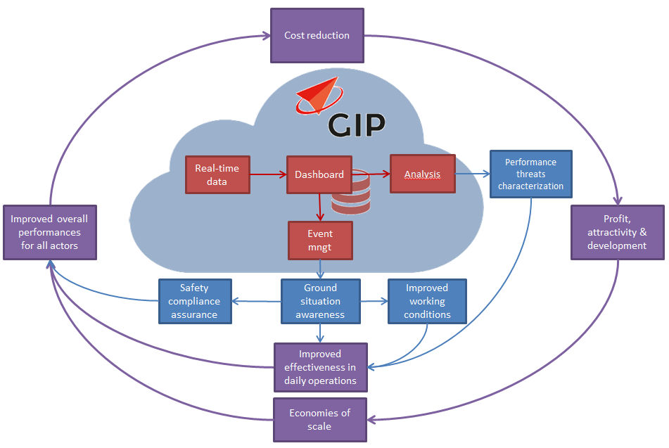
GIP4 Smart Airports value proposition are the following:
- Newness: Integrated and user needs-driven solution at airport level addressing the mains issues encountered by the main actors of the airport ecosystem (airport itself, airlines, and handling companies)
- Performances:
-
- Event management - detection and follow-up
- Integrated analysis and report of the airport performance
- Threats characterisation thanks to historical data analysis
- Improved effectiveness in daily operations for all airport actors
- Customisation:
-
- Tailored solution and features according to specific user needs
- Personalized relationship between the provider and the customer
- Cost reduction:
-
- Cost reduction for all actors thanks a better understanding, forecasting, and operational management of delays and other events.
- Risk reduction:
-
- Improved ground situation awareness for all actors
- Safety compliance assurance
- Convenience:
-
- Improved working conditions for the different airport (especially the handlers)
- H24 after-sales maintenance available
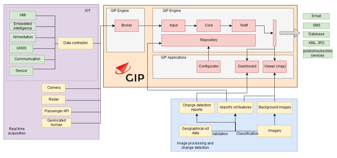
The high-level architecture and building blocks are the following
Space Added Value
The following space assets are used in the project:
(1) Earth Observation data
One of the project objectives is to use multi-sensor EO data to provide the airports actors with high-resolution map of the outdoor surface elements as well as up-to-date indicators of their conditions to support operational, maintenance, and surveillance activities and improve efficiency.
Thanks to their very high spatial resolution, VHR satellite data (such as Pleiades), airborne and RPAS-embedded imagery can be used to precisely map the airport. Secondly, thanks to their very high temporal resolution, Copernicus data (both Sentinel-1 and Sentinel-2) can be valued as a surveillance tool providing up-to-date situation of the airport.
(2) Global Navigation Positioning Systems and Space-Based Augmentation Systems
The use of Europeans GNSS (EGNSS), such as Galileo and EGNOS is crucial for safety-critical application such as airport operations and management, by enabling better positioning accuracy for airport vehicles we intend to track (superior measurements quality, higher number of satellite while combining multiple constellations) and strengthens integrity monitoring and system reliability (eg. by using multi-constellation ARAIM techniques).
Current Status
Following the successful Factory Acceptance Test milestone achieved in a meeting held at Oscars’ premises (Andenne, BE) in November 2022, the project team focused on the deployment of the solution in order to prepare the trials kick off with pilot users. HIA has shown positive feedback on the application to allow to start the pilot phase at their premise. The SmartTurn application was also upgraded in order to be cloud-ready. This new feature allows OSCARS’ solution to use external datasets to be compatible with any airport. A first running version of this online SmartTurn will be to Liege Airport as a pilot case, combining external APIs about planning and aircraft feeds and some simulated datasets for vehicle tracking. Trial activities have indeed been authorised by ESA, following the successful on-Site Acceptance Test review meeting held in September 2023.
Prime Contractor(s)
Subcontractor(s)