
Objectives of the service
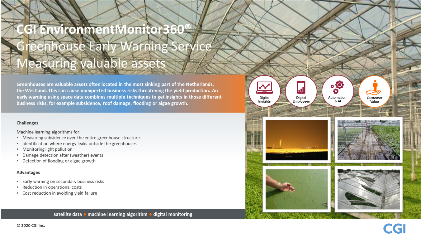
The Greenhouse Early Warning Service is based on the application of space data for risk mitigation and damage prevention for greenhouse owners to ensure continuity of their business.
Greenhouse owners produce crops at large scales in a competitive industry. Greenhouses are used to create the most favourable conditions for products to grow. Different technologies are used to enhance their business performance, e.g. climate regulating systems to control temperature and watering systems for the plants. Supporting technology such as monitoring systems can be essential to ensure efficiency of the business, particularly due to the large scale of greenhouses. Some challenges faced by greenhouse owners are:
- Subsidence: Subsidence causes issues related to the structural integrity of a greenhouse. While costly to repair, it also affects the internal systems, thereby negatively affecting production and yield.
- Temperature Distribution: Uneven or unexpected temperature distribution caused by damages and malfunctions causes the climate control system of a greenhouse to compensate, resulting in higher cost for the greenhouse owner.
The Greenhouse Early Warning Service provides a notification service using space data to monitor subsidence and temperature. These insights help greenhouse owners prevent or mitigate non-insurable risks threatening their business, thereby saving costs.
Users and their needs
The targeted users of the service are both the greenhouse owners and the service provider. The greenhouse owner subscribes to this service via a service provider.
The needs of the greenhouse owners are reflected by the challenges they face in order to stay ahead in the market. They need to gain insight into the risks threatening their business, to take action to ensure that they can meet their clients’ demands and stay competitive. Information based on monitoring their assets is the first step in protecting their business operations.
The needs of the greenhouse owners are:
- Innovative solutions and technology in order to maintain a strong position in the market
- Solutions to maintain effective business operations when exposed to risks
- Preventing damage of assets caused by uncontrollable events
Service providers in this sector have the same need of staying competitive in the market, by providing services that benefit their clients (the greenhouse owners). Their needs are:
- To continuously improve their services in accordance with clients’ needs
- To create innovative solutions for clients using the newest technologies
- To create services which addresses the different issues experienced by their clients
Service/ system concept
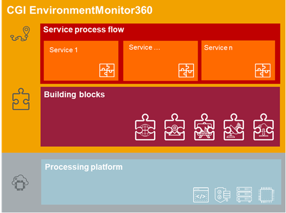
This service provides notifications of monitoring results detectable from space to greenhouse owners. Satellite data, location data and if applicable, ancillary data, will be processed in CGI’s EnvironmentMonitor360 to provide data insights. By acquiring this service e.g. via PinC Agro (an (innovative) risk management consulting firm in the agricultural sector and part of Achmea insurance company), greenhouse owners subscribe to receiving notifications about the status of subsidence of their buildings and the temperature distribution of their property. In this use case scenario, the greenhouse owners receive advice from PinC Agro on how to handle the status update and are then able to take action when needed.
The EnvironmentMonitor360 combines and converts data into information, using CGI’s Data Scientists’ skills and expertise in remote sensing. The greenhouse owners can configure the PinC Agro service to receive customized email notifications related to the issues he experience as affecting his assets.
Space Added Value
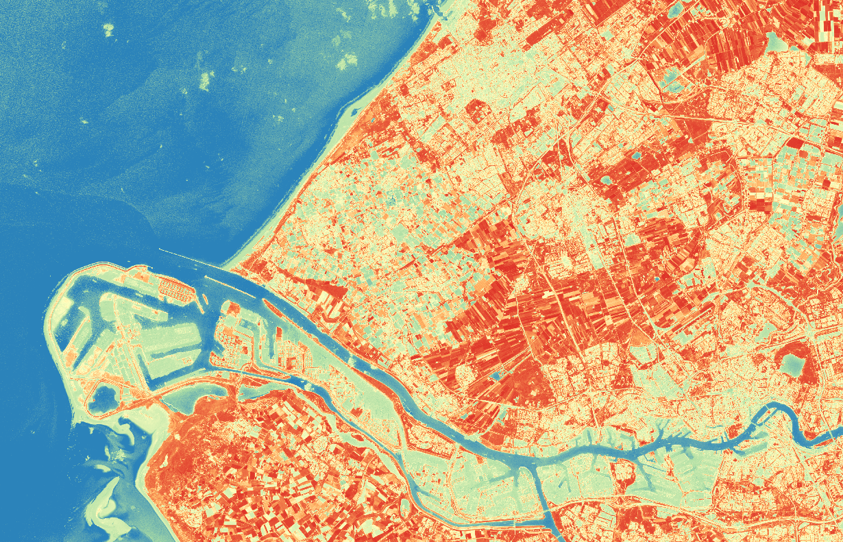
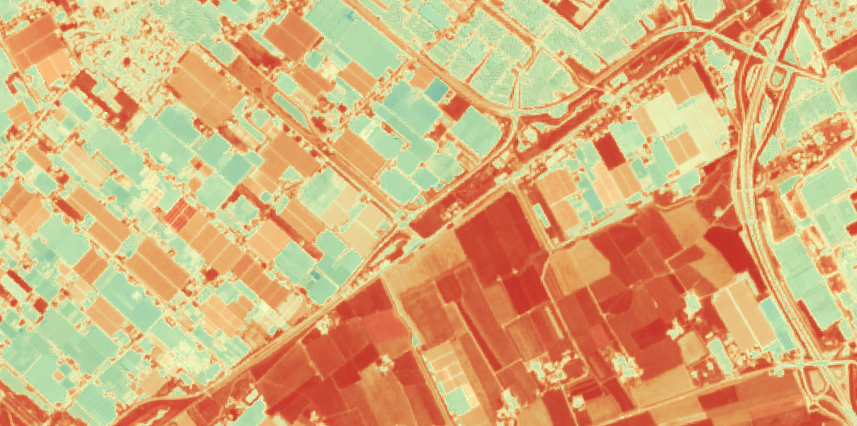
For this service, Earth Observation satellites are utilized, specifically optical and SAR imagery. The advantage of imaging satellites is their ability to monitor large areas over time, which creates a continuous stream of information. Algorithms and models are developed specifically to process imagery into valuable information for the greenhouse owner.
The imagery is combined with location data of greenhouses. Multi-temporal imagery is processed for the location through a series of models and based on time-series and spatial analysis, a notification is sent to the user. The notification report will include an overview of the current status of subsidence or temperature distribution, incl. highlights of results.
Current methods used by greenhouse owners are manual and time consuming. Some utilize ground sensors, however the common approach is to manually inspect their assets. This method requires time and resources and the condition of their assets is unknown between inspections. Combined with the fact that greenhouses are continuously increasing in size, the sector is in need of innovative, low cost and low effort solutions to managing risks, which is what space data can provide.
Current Status
The final phase of the project included validation of the EO subsidence model. This was concluded successfully and the pre-operational service now includes two sub-services:
- Subsidence Monitoring: Updates are sent to the end user every 3 months with an overview of current subsidence on his property. The precision of the results are in mm.
- Temperature Distribution: Updates are sent to the end user every week (depending on weather circumstances) with an overview of the temperature distribution on his property in 10 x 10 meters resolution.
The Greenhouse Early Warning Service demonstrator project has been concluded and the Final Review was held in January 2021. The pre-operational service has been designed and implemented and is ready for roll-out. We are currently in talks with the launching customer to see how we can roll-out the service within The Netherlands and Canada and thereby take the service into an operational phase.