
Objectives of the service
Distribution network operators have to maintain the assets they own within their network. To do so, they must periodically perform surveys to determine the health of their assets.
Currently, imagery is captured by helicopters for an assessor engineer, that assesses back at base the condition of each part of the assets. Not only does it have risk element associated with it for the pilots and engineers/observers, it can also cause harm to livestock and damage the crops.
The images are assessed manually, a lengthy and costly process. As it is a considerably monotonous and repetitive task, it is prone to inaccuracies. This has an impact both on the timeliness of decisions and the allocation of resources.
The objective of the Kick start activity was to investigate whether it is technically and commercially viable to perform the analysis of imagery captured by drones automatically with the help of machine learning.
The built solution looks at a vast array of aerial photography of electrical towers, automatically taggings their geographical location, and which part of the asset it is from. It then detects the asset’s condition and labels the image accordingly. Critical issues are identified in close to real time, enabling addressing issues as they arise.
Users and their needs
The primary users are UK Distribution Network Operators (DNO) and their asset management teams.
DNOs own and operate the system of cables and towers that provide energy from the national grid to private households and businesses. Foresense SEIA seeks to support their responsibilities relating to maintaining their distribution networks, in particular towers.
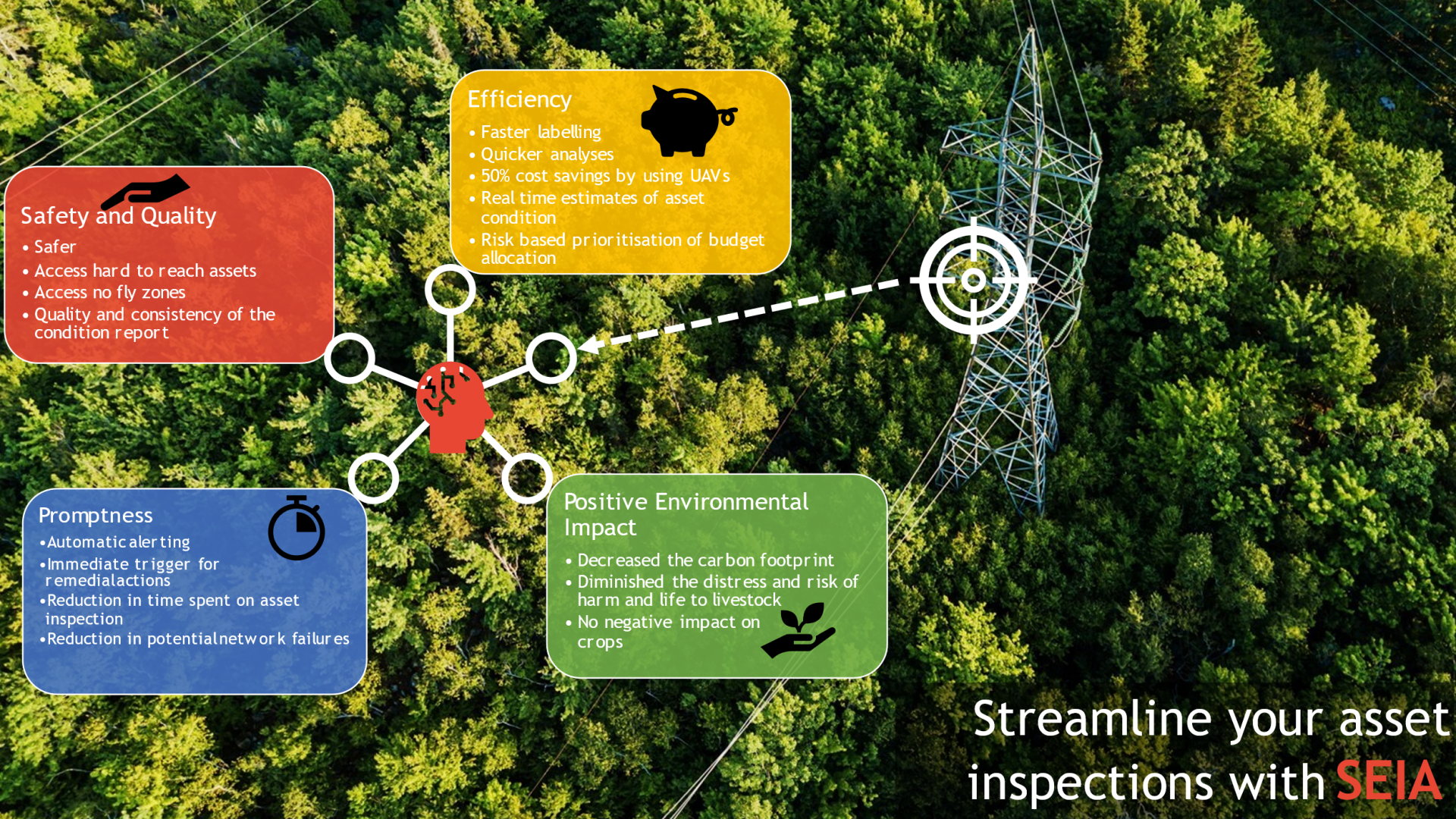
DNOs are incentivised to deliver their service as efficiently as possible, meaning that they have to increase their assets performance and reliability while at the same time reducing their operating and capital costs. The pressures that DNOs face are multi-faceted and often conflicting. Companies need to balance the rising maintenance and monitoring costs that relate to their ageing assets while also minimising their expenses. Not only that, they are under increasing scrutiny of being to be more environmentally mindful, decreasing their carbon emissions and minimising the impact on the environment they operate in. Furthermore, they also need to have a positive impact on the health and safety of their staff.
The users’ key needs are to improve their processes relating to:
- Their efficiency
- The promptness with which they carry out their assessments and resulting decisions,
- The quality of their assessments, and safety of their processes,
- Their environmental impact
Service/ system concept
SEIA streamlines the asset inspection process by
- Estimating the condition of assets from images using state of the art deep learning computer vision models.
- Automatically assigning images (and thus condition scores) to assets using GNSS data embedded in the images
- Aggregating condition scores and generating reports to provide a complete overview of asset condition
- Immediately alerting to critical issues
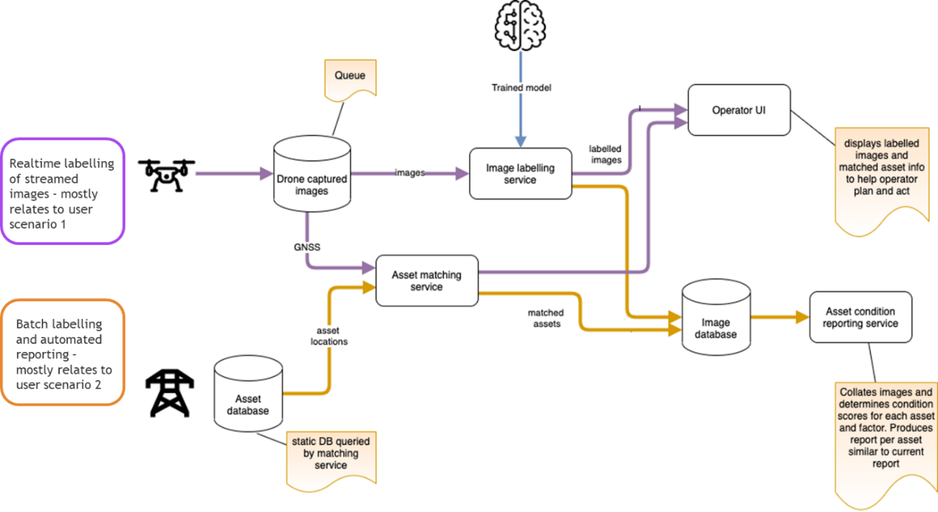
The service is designed to operate in two complementary modes as indicated in Figure 1:
- Processing images and estimating asset condition in real-time – images streamed from a UAV or other camera to a tablet are overlayed with condition estimate information and critical issues are highlighted for immediate attention
- In batch mode - images are uploaded to SEIA servers for condition assessment and automated report generation. Condition reports and underlying data can also be explored and validated using the web UI.
Space Added Value
SEIA relies on Global Navigation Satellite System (GNSS) data to provide accurate location information for survey imagery. GNSS data is extracted from image metadata or directly from the UAV which allows the image to be automatically associated with the asset being surveyed. This automatic asset matching can save significant amounts of time when hundreds or thousands of assets are being surveyed and avoids errors associated with manual data entry. In the future we aim to go further and calculate the orientation of the image with respect to the asset, which will allow for quicker location of issues identified during the survey.
Current Status
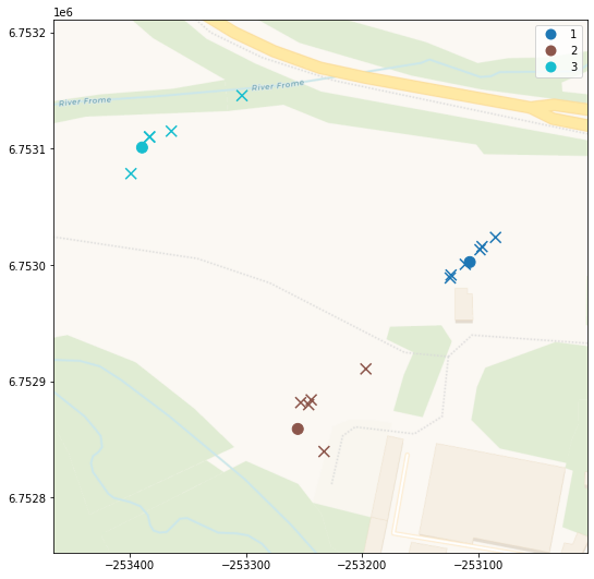
During the Kick start activity a series of workshops were held with NPg to understand user profiles, scenarios and needs. With data provided by NPg a proof of concept solution was designed and trained. The condition assessment system, built as the proof of concept, can automatically assign images to the correct asset using GNSS data as shown in Figure 2, and use deep learning to accurately predict the condition of steel towers according to six distinct criteria.
As well as NPg we have also engaged with National Grid in the UK and are currently in discussions about potential follow on activity and future support for continued development of SEIA.
The Final Review was successfully held on 11 June 2021. A demonstration project is not envisaged.