
Objectives of the service
Image credit: TerrAria srl, Project: EPICO19
When in February 2020 the COVID-19 outbreak swept across Italy, health professionals had to face and tackle an entirely new epidemic, without the necessary tools to analyse, understand and curtail it.
The main objective of EPICO19 service is to support public health technicians and decision makers in managing the COVID-19 outbreak providing them with:
- to map, monitor and forecast the spread of the outbreak through a machine learning model
- to assess the effect of public health measures according to a what-if approach both in the past and in the future: e.g. modelling what would have happened in the first and second wave identifying the best interventions to better control a possible third wave
- to monitor vulnerability and crowding of population through satellite observation, respectively modelling exposure to air pollution and counting and geo-locating vehicles with an AI engine
- to implement a DSS (Decision Support System) integrating all the previous functionalities in a single Web-platform
Users and their needs
EPICO19 system has been tested during the Pilot in the Reggio Emilia province, the most affected one by the COVID-19 in Emilia Romagna, thanks to the end-user Reggio Emilia Health Authority – AUSL_RE - ‘Azienda USL di Reggio Emilia’. AUSL_RE provides health care and public health services to the 42 Municipalities of the Reggio Emilia province, with a total population of 535’000 inhabitants.
Main user-needs are:
- a geographical information system to monitor and analyse the distribution of cases supporting the individuation of possible pandemic outbreaks
- an epidemiological model based on the past waves, to predict the future spread of COVID-19 and similar pandemics
- assessing the efficacy of public health measures supporting with a what-if modelling approach
- assessing the role of risk factors such as crowding and air pollution, based on satellite images
- providing a user-friendly web-tool supporting spatial and temporal analysis of health and environmental indicators and their combinations and processing
- making available real time update and forecast of the spread of the outbreak.
The key user segments targeted by our product are the Local Health Authorities but also public institution having in charge the pandemics management (e.g. prefectures, civil protection…).
Service/ system concept
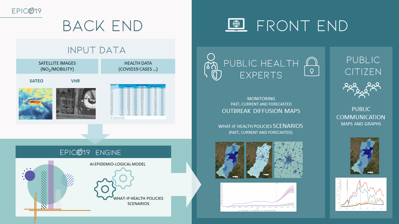
Image credit: TerrAria srl, Project: EPICO19
EPICO19 is a web application allowing to predict the spread of the outbreak in terms of cases and hospitalization based on a machine learning engine that uses:
- health data
- crowding indicators through AI-algorithms processing VHR satellite images
- air pollution exposure through Satellite Earth Observation modelling
EPICO19 Back-End (BE): the whole set of processes, databases and pre/post-processors that make up the "engine" of the system. Main components are
- Health parameter spatial and temporal database
- Environmental parameter database derived from satellite images (crowding, NO2 and PM concentrations, meteorological parameters)
- Machine learning epidemiological model to forecast health policies scenarios through a what-if approach
Front-End (FE): Graphical User Interfaces represented by a map-centric web platform; whose main outcomes are:
- • Analysing past outbreaks spread and dynamics
- • Monitoring current outbreak spread through diffusion maps with municipal and census section detail
- • Forecasting the spread outbreak and the effectiveness of lockdown/mobility restrictions to curb the outbreak in the study area
- • Reporting map and time series of health parameters and indicators
EPICO19 has a restricted access for public health experts with all EPICO19 functionalities.
Space Added Value
EPICO19 space assets include CAMS service and VHR imagery.
CAMS’ analysis service which incorporates observations from satellite instruments (e.g, Sentinel-5P) and ground data, combining them with modelling to estimate PM10, PM2.5, NO2 air concentration has been used in the model developed in UTAQ project (www.utaq.eu) by TerrAria for ECMWF (European Centre for Medium-range Weather Forecasts). Air pollution is used to assess vulnerability of population and meteorological conditions that may influence the spread of the infection.
VHR satellite and aerial imagery, with a ground resolution respectively of 30-50 cm and 11 cm, are used to estimate the crowding index. Images will be analysed by an Artificial Intelligence vision proprietary algorithm by Studiomapp, pulling out up to 100 classes of objects. This enables to count the number of cars, busses or trucks, and to assess the presence of people in sites where crowding is expected to occur, such as hospitals, parking lots, supermarkets, working places, train stations, and logistic hubs.
Air pollution and crowding index are among the input of EPICO19 epidemiological model, which is also based on meteorological data and on space and time distribution of COVID-19 cases. EPICO19 therefore combines advanced AI and environmental techniques based on satellite resources with machine learning techniques on epidemiological data.
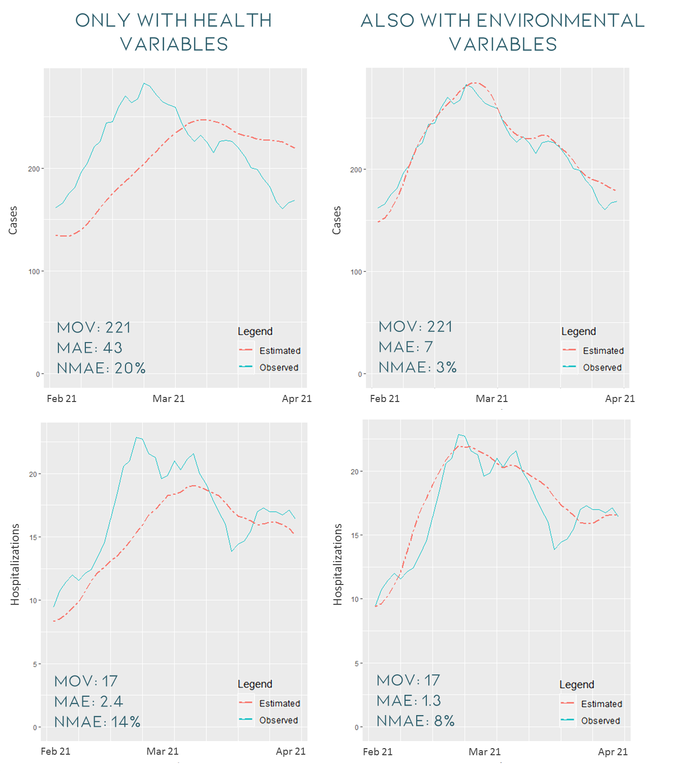
In order to evaluate the contribution of the environmental variables in improving the forecast performance, the following figures report the results obtained using only the health variables (in the left column) compared with the performances achieved with also the contribution of environmental variables (in the right column). The results refer to the validation period, i.e. February-March 2021, at provincial level for case and hospitalization models, respectively.
Performances definitely improve by adding environmental variables: the models are able to reproduce much better the trend of the wave recorded during the validation period. For the cases, the mean observed value (MOV) of the period is 221 cases at the provincial level and the average absolute error (MAE) is approximately 7 cases, which corresponds to an average percentage error (nMAE) of approximately 3%, compared to 20% without considering environmental variables. For hospitalizations, the MOV of the period is 17 hospitalizations and the MAE over the entire period at the provincial level is equal to 1.3 hospitalizations, compared to 2.4 only with the health variables.
Current Status
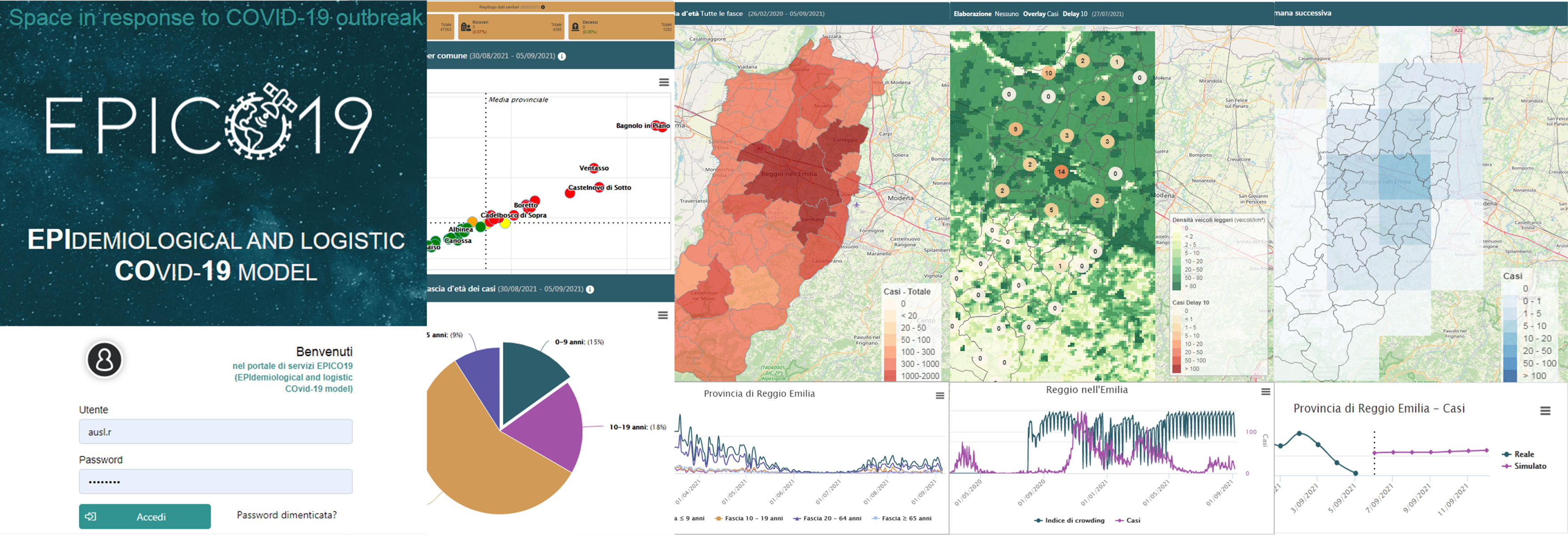
Image credit: TerrAria srl, Project: EPICO19
EPICO19 is a fully operational prototype, tested and customized in the operational context of Reggio Emilia. Since April 2021, the beginning pilot phase, the experimentation by the AUSL of Reggio Emilia end-user has started and EPICO19 is currently used as an operational tool.
EPICO19 system is updated each Monday with the new daily available data (health, mobility air quality, meteorological data) of the last week, providing simulation forecasts for the next week of cases and hospitalizations.
Up to now, the epidemiological model has achieved more than satisfactory performances in forecasting cases and hospitalizations in the Reggio Emilia province: for example, from February 2021 to November 2021, the accuracy obtained by the cases model for the total positives forecast of the entire Reggio Emilia’s province was respectively quantified as a MAE (Mean Absolute Error) of 16.9 cases, while the hospitalizations model achieved a MAE of 1.2 hospitalizations.
A demo version of the application is available to offer an overview of the tool’s potential for other AUSL in Regione Emilia Romagna or in other regions. To get EPICO19 demo access or to have more details on the tool, write to: epico19@terraria.com